| [3] |
Name on the Register[4] |
Image |
Date listed[5] |
Location |
City or town |
Description |
|---|
| 1 |
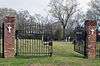
Alcorn State University Historic District |
|
000000001982-05-20-0000May 20, 1982
(#82003098) |
Alcorn State University campus
31°52′32″N 91°08′59″W / 31.875556°N 91.149722°W / 31.875556; -91.149722 (Alcorn State University Historic District) |
Lorman |
|
| 2 |
Bayou Pierre Site |
Upload image |
000000001978-06-23-0000June 23, 1978
(#78001596) |
Address Restricted
|
Port Gibson |
|
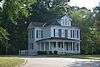
| 3 |
Bethel Presbyterian Church |
|
000000001978-11-28-0000November 28, 1978
(#78001594) |
North of Alcorn on Mississippi Highway 552
31°54′21″N 91°07′44″W / 31.905833°N 91.128889°W / 31.905833; -91.128889 (Bethel Presbyterian Church) |
Alcorn |
|
| 4 |
Buena Vista Cotton Gin |
Upload image |
000000001974-12-27-0000December 27, 1974
(#74001059) |
Northeast of Port Gibson
31°59′23″N 90°54′35″W / 31.9897°N 90.9097°W / 31.9897; -90.9097 (Buena Vista Cotton Gin) |
Port Gibson |
|
| 5 |
Building at 801 Chinquepin Street |
Upload image |
000000001979-07-22-0000July 22, 1979
(#79003420) |
801 Chinquepin St.
31°57′18″N 90°58′41″W / 31.955°N 90.978056°W / 31.955; -90.978056 (Building at 801 Chinquepin Street) |
Port Gibson |
|
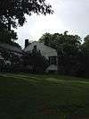
| 6 |
Canemount |
|
000000001982-12-02-0000December 2, 1982
(#82000572) |
North of Alcorn off Mississippi Highway 552
31°53′40″N 91°07′34″W / 31.894444°N 91.126111°W / 31.894444; -91.126111 (Canemount) |
Alcorn |
|
| 7 |
Catholic Cemetery |
|
000000001979-07-22-0000July 22, 1979
(#79003425) |
700 Coffee St.
31°57′21″N 90°58′43″W / 31.955833°N 90.978611°W / 31.955833; -90.978611 (Catholic Cemetery) |
Port Gibson |
|
| 8 |
Catledge Archeological Site |
Upload image |
000000001974-07-15-0000July 15, 1974
(#74001058) |
Address Restricted
|
Alcorn |
|
| 9 |
Centers Creek Mound |
Upload image |
000000001973-08-14-0000August 14, 1973
(#73001003) |
Address Restricted
|
Russum |
|
| 10 |
Chamberlain-Hunt Academy Historic District |
|
000000001979-07-22-0000July 22, 1979
(#79003411) |
Roughly bounded by U.S. Route 61, the city limits, Woodstock St., and Mississippi Highway 547
31°56′43″N 90°59′12″W / 31.945278°N 90.986667°W / 31.945278; -90.986667 (Chamberlain-Hunt Academy Historic District) |
Port Gibson |
|
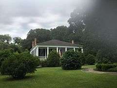
| 11 |
Claremont |
Upload image |
000000001979-07-22-0000July 22, 1979
(#79003418) |
366 Claremont Dr.
31°56′59″N 90°59′33″W / 31.949722°N 90.9925°W / 31.949722; -90.9925 (Claremont) |
Port Gibson |
|
| 12 |
Collina |
|
000000001979-07-22-0000July 22, 1979
(#79003419) |
Greenwood St. Extension
31°57′15″N 90°59′25″W / 31.954167°N 90.990278°W / 31.954167; -90.990278 (Collina) |
Port Gibson |
|
| 13 |
Drake Hill Historic District |
Upload image |
000000001979-07-22-0000July 22, 1979
(#79003412) |
Drake Hill Rd.
31°57′36″N 90°59′17″W / 31.96°N 90.988056°W / 31.96; -90.988056 (Drake Hill Historic District) |
Port Gibson |
|
| 14 |
Golden West Cemetery |
Upload image |
000000001979-07-22-0000July 22, 1979
(#79003417) |
Rodney Rd.
31°57′26″N 90°59′30″W / 31.957222°N 90.991667°W / 31.957222; -90.991667 (Golden West Cemetery) |
Port Gibson |
|
| 15 |
Grand Gulf Military State Park |
|
000000001972-04-11-0000April 11, 1972
(#72000689) |
6 miles west of Port Gibson
31°31′58″N 91°03′00″W / 31.532778°N 91.05°W / 31.532778; -91.05 (Grand Gulf Military State Park) |
Port Gibson |
|
| 16 |
Idlewild |
|
000000001979-07-22-0000July 22, 1979
(#79003416) |
310 Idlewild Dr.
31°57′00″N 90°59′14″W / 31.95°N 90.987222°W / 31.95; -90.987222 (Idlewild) |
Port Gibson |
|
| 17 |
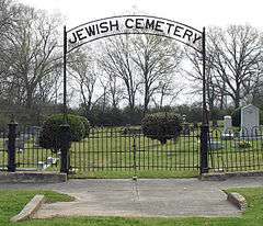
Jewish Cemetery |
|
000000001979-07-22-0000July 22, 1979
(#79003415) |
900 Marginal St.
31°57′22″N 90°58′45″W / 31.956111°N 90.979167°W / 31.956111; -90.979167 (Jewish Cemetery) |
Port Gibson |
|
| 18 |
Market Street-Suburb Ste. Mary Historic District |
|
000000001979-07-22-0000July 22, 1979
(#79003410) |
Roughly bounded by Orange, Marginal, Greenwood, and Market Sts.
31°57′27″N 90°58′56″W / 31.9575°N 90.982222°W / 31.9575; -90.982222 (Market Street-Suburb Ste. Mary Historic District) |
Port Gibson |
|
| 19 |
McGregor |
Upload image |
000000001979-07-22-0000July 22, 1979
(#79003424) |
Mississippi Highway 547
31°56′32″N 90°58′37″W / 31.942222°N 90.976944°W / 31.942222; -90.976944 (McGregor) |
Port Gibson |
|
| 20 |
John Nelson Site |
Upload image |
000000001974-06-13-0000June 13, 1974
(#74001060) |
Address Restricted
|
Willows |
|
| 21 |
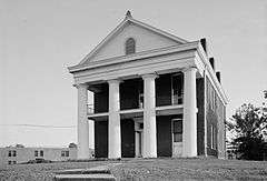
Oakland Chapel |
|
000000001974-12-27-0000December 27, 1974
(#74001057) |
Alcorn State University campus
31°52′33″N 91°08′22″W / 31.875833°N 91.139444°W / 31.875833; -91.139444 (Oakland Chapel) |
Alcorn |
|
| 22 |
Old Brickyard Place |
Upload image |
000000001979-07-22-0000July 22, 1979
(#79003423) |
Anthony St.
31°58′09″N 90°59′29″W / 31.969167°N 90.991389°W / 31.969167; -90.991389 (Old Brickyard Place) |
Port Gibson |
|
| 23 |
Old Depot Restaurant and Lounge |
|
000000001979-07-22-0000July 22, 1979
(#79003421) |
1202 Market St.
31°57′20″N 90°59′15″W / 31.955556°N 90.9875°W / 31.955556; -90.9875 (Old Depot Restaurant and Lounge) |
Port Gibson |
|
| 24 |
Old Natchez Trace (132-3T) |
|
000000001976-11-07-0000November 7, 1976
(#76000161) |
Northeast of Port Gibson at milepost 45.8 of the Natchez Trace Parkway
32°00′10″N 90°53′46″W / 32.002778°N 90.896111°W / 32.002778; -90.896111 (Old Natchez Trace (132-3T)) |
Port Gibson |
An original segment of the Natchez Trace.[6]
|
| 25 |
Owens Creek Bridge |
Upload image |
000000001988-11-16-0000November 16, 1988
(#88002398) |
Spans Owen Creek on an old county road
32°05′29″N 90°43′45″W / 32.091389°N 90.729167°W / 32.091389; -90.729167 (Owens Creek Bridge) |
Utica |
|
| 26 |
Port Gibson Battle Site |
Upload image |
000000002005-04-05-0000April 5, 2005
(#05000461) |
West of Port Gibson
31°57′28″N 91°01′08″W / 31.9578°N 91.0189°W / 31.9578; -91.0189 (Port Gibson Battle Site) |
Port Gibson |
|
| 27 |
Port Gibson Battlefield |
Upload image |
000000001972-11-03-0000November 3, 1972
(#72000690) |
4 miles west of Port Gibson
31°57′28″N 91°01′08″W / 31.957778°N 91.018889°W / 31.957778; -91.018889 (Port Gibson Battlefield) |
Port Gibson |
|
| 28 |
Port Gibson High School (Old) |
Upload image |
000000002016-05-17-0000May 17, 2016
(#16000285) |
161 Ramsey Dr.
31°57′07″N 90°59′13″W / 31.952075°N 90.986971°W / 31.952075; -90.986971 (Port Gibson High School (Old)) |
Port Gibson |
|
| 29 |
Port Gibson Oil Works Mill Building |
Upload image |
000000001979-07-22-0000July 22, 1979
(#79003422) |
Anthony St.
31°57′54″N 90°59′25″W / 31.965°N 90.990278°W / 31.965; -90.990278 (Port Gibson Oil Works Mill Building) |
Port Gibson |
|
| 30 |
Sacred Heart Roman Catholic Church |
|
000000001987-11-23-0000November 23, 1987
(#73002241) |
Grand Gulf Military Monument Park
32°02′00″N 91°03′11″W / 32.033333°N 91.053056°W / 32.033333; -91.053056 (Sacred Heart Roman Catholic Church) |
Port Gibson |
|
| 31 |
Smithfield Site |
Upload image |
000000001978-06-09-0000June 9, 1978
(#78001595) |
Address Restricted
|
Bruinsburg |
|
| 32 |
Valley of the Moon Bridge |
Upload image |
000000002005-06-08-0000June 8, 2005
(#05000561) |
Willows Rd. at its crossing of Bayou Pierre, 2 miles southeast of Willows
32°01′03″N 90°52′37″W / 32.0175°N 90.876944°W / 32.0175; -90.876944 (Valley of the Moon Bridge) |
Port Gibson |
|
| 33 |
Van Dorn House |
|
000000001971-06-21-0000June 21, 1971
(#71000446) |
Van Dorn Dr.
31°56′24″N 91°02′15″W / 31.94°N 91.0375°W / 31.94; -91.0375 (Van Dorn House) |
Port Gibson |
|
| 34 |
Widow's Creek Bridge |
Upload image |
000000001988-11-16-0000November 16, 1988
(#88002409) |
Spans Widow's Creek on a county road
31°56′30″N 91°03′03″W / 31.941667°N 91.050833°W / 31.941667; -91.050833 (Widow's Creek Bridge) |
Port Gibson |
|
| 35 |
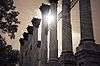
Windsor Ruins |
|
000000001971-11-23-0000November 23, 1971
(#71000447) |
12 miles southwest of Port Gibson on Mississippi Highway 552
31°56′26″N 91°07′46″W / 31.94056°N 91.12944°W / 31.94056; -91.12944 (Windsor Ruins) |
Port Gibson |
|
| 36 |
Windsor Site |
Upload image |
000000001979-02-07-0000February 7, 1979
(#79003126) |
Address Restricted
|
Port Gibson |
|
| 37 |
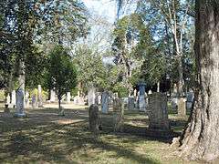
Wintergreen Cemetery |
|
000000001979-07-22-0000July 22, 1979
(#79003414) |
E. Greenwood St.
31°57′05″N 90°58′45″W / 31.951389°N 90.979167°W / 31.951389; -90.979167 (Wintergreen Cemetery) |
Port Gibson |
|


.jpg)

.jpg)