| [3] |
Name on the Register |
Image |
Date listed[4] |
Location |
City or town |
Description |
|---|
| 1 |
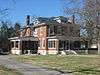
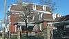
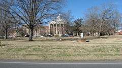
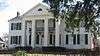
Alumni-Latham-Mooreland Historic District |
|
000000001993-07-22-0000July 22, 1993
(#93000696) |
Alumni Ave., Latham Ave., and Mooreland Dr.
36°51′15″N 87°29′47″W / 36.854167°N 87.496389°W / 36.854167; -87.496389 (Alumni-Latham-Mooreland Historic District) |
Hopkinsville |
|
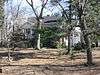
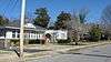
| 2 |
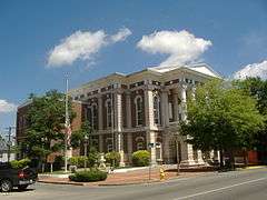
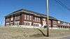
Attucks High School |
|
000000002013-01-23-0000January 23, 2013
(#12001199) |
712 E. 1st. St.
36°52′08″N 87°28′41″W / 36.868987°N 87.478135°W / 36.868987; -87.478135 (Attucks High School) |
Hopkinsville |
|
| 3 |
C.A. Baldwin Farmstead |
Upload image |
000000002015-09-29-0000September 29, 2015
(#15000648) |
2680 Masonville-Beverly Rd.
36°45′54″N 87°30′57″W / 36.7651°N 87.5159°W / 36.7651; -87.5159 (C.A. Baldwin Farmstead) |
Hopkinsville |
|
| 4 |
Beverly School |
Upload image |
000000001979-04-30-0000April 30, 1979
(#79003624) |
Off Kentucky Route 107
36°45′43″N 87°31′29″W / 36.761944°N 87.524722°W / 36.761944; -87.524722 (Beverly School) |
Hopkinsville |
|
| 5 |
Blue Lantern Farm |
Upload image |
000000001979-04-30-0000April 30, 1979
(#79003626) |
U.S. Route 68
36°52′25″N 87°31′18″W / 36.873611°N 87.521667°W / 36.873611; -87.521667 (Blue Lantern Farm) |
Hopkinsville |
|
| 6 |
Boatright House |
Upload image |
000000001979-04-30-0000April 30, 1979
(#79003611) |
Off U.S. Route 41
36°50′49″N 87°26′55″W / 36.846944°N 87.448611°W / 36.846944; -87.448611 (Boatright House) |
Hopkinsville |
|
| 7 |
Bradshaw House |
Upload image |
000000001979-04-30-0000April 30, 1979
(#79003623) |
Off Kentucky Route 107
36°45′44″N 87°31′19″W / 36.762222°N 87.521944°W / 36.762222; -87.521944 (Bradshaw House) |
Hopkinsville |
|
| 8 |
Campbell House |
Upload image |
000000001979-04-30-0000April 30, 1979
(#79003627) |
Junction of Kentucky Routes 164 and 272
36°51′30″N 87°33′49″W / 36.858333°N 87.563611°W / 36.858333; -87.563611 (Campbell House) |
Hopkinsville |
|
| 9 |
Cedar Grove |
Upload image |
000000001977-11-17-0000November 17, 1977
(#77000608) |
East of Oak Grove off Kentucky Route 115
36°39′15″N 87°22′36″W / 36.654167°N 87.376667°W / 36.654167; -87.376667 (Cedar Grove) |
Oak Grove |
|
| 10 |
Church Hill Grange Hall |
Upload image |
000000001975-08-28-0000August 28, 1975
(#75000744) |
5.5 miles (8.9 km) southwest of Hopkinsville on Cox Mill Rd. (Kentucky Route 695)
36°47′58″N 87°34′28″W / 36.799444°N 87.574444°W / 36.799444; -87.574444 (Church Hill Grange Hall) |
Hopkinsville |
|
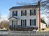
| 11 |
Confederate Memorial Fountain in Hopkinsville |
|
000000001997-07-17-0000July 17, 1997
(#97000710) |
3 blocks north of the junction of U.S. Route 41 and Main St.
36°52′00″N 87°29′17″W / 36.866667°N 87.488056°W / 36.866667; -87.488056 (Confederate Memorial Fountain in Hopkinsville) |
Hopkinsville |
|
| 12 |
Cox House |
Upload image |
000000001979-04-30-0000April 30, 1979
(#79003615) |
South of Kentucky Route 272
36°49′06″N 87°40′22″W / 36.818333°N 87.672778°W / 36.818333; -87.672778 (Cox House) |
Julien |
|
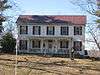
| 13 |
Judge Joseph Crockett House |
|
000000001979-04-03-0000April 3, 1979
(#79000968) |
317 E. 16th St.
36°51′38″N 87°29′18″W / 36.860556°N 87.488333°W / 36.860556; -87.488333 (Judge Joseph Crockett House) |
Hopkinsville |
|
| 14 |
Dalton Brick Company |
Upload image |
000000001979-04-30-0000April 30, 1979
(#79003606) |
N. Elm St.[5]
36°52′26″N 87°29′25″W / 36.873889°N 87.490278°W / 36.873889; -87.490278 (Dalton Brick Company) |
Hopkinsville |
|
| 15 |
Monroe Dalton House |
|
000000001983-02-10-0000February 10, 1983
(#83002624) |
713 E. 7th St.
36°51′49″N 87°28′56″W / 36.863611°N 87.482222°W / 36.863611; -87.482222 (Monroe Dalton House) |
Hopkinsville |
|
| 16 |
East 7th Street Historic District |
|
000000001983-09-07-0000September 7, 1983
(#83000561) |
Roughly bounded by E. 7th St. from Campbell to Belmont Sts.
36°51′49″N 87°28′52″W / 36.863611°N 87.481111°W / 36.863611; -87.481111 (East 7th Street Historic District) |
Hopkinsville |
|
| 17 |
Elk Grove Farm |
Upload image |
000000001979-04-30-0000April 30, 1979
(#79003613) |
Off U.S. Route 41A
36°45′37″N 87°27′37″W / 36.760278°N 87.460278°W / 36.760278; -87.460278 (Elk Grove Farm) |
Hopkinsville |
|
| 18 |
Elliott Place |
Upload image |
000000001979-04-30-0000April 30, 1979
(#79003617) |
North of Lafayette Rd.
36°39′31″N 87°37′43″W / 36.658611°N 87.628611°W / 36.658611; -87.628611 (Elliott Place) |
LaFayette |
|
| 19 |
Fairelond |
|
000000001983-09-07-0000September 7, 1983
(#83000562) |
1303 E. 7th St.
36°51′45″N 87°28′29″W / 36.8625°N 87.474722°W / 36.8625; -87.474722 (Fairelond) |
Hopkinsville |
|
| 20 |
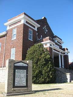
Freeman Chapel C.M.E. Church |
|
000000001983-05-26-0000May 26, 1983
(#83000563) |
137 S. Virginia St.
36°52′08″N 87°29′08″W / 36.868889°N 87.485556°W / 36.868889; -87.485556 (Freeman Chapel C.M.E. Church) |
Hopkinsville |
|
| 21 |
Simon French House |
Upload image |
000000001979-04-30-0000April 30, 1979
(#79003622) |
Carter Rd., South of Barkers Mill
36°39′10″N 87°21′32″W / 36.652778°N 87.358889°W / 36.652778; -87.358889 (Simon French House) |
Hensleytown |
|
| 22 |
John C. Gary House |
Upload image |
000000001979-04-30-0000April 30, 1979
(#79003629) |
Gary Lane, south of Kentucky Route 695
36°48′45″N 87°31′45″W / 36.8125°N 87.529167°W / 36.8125; -87.529167 (John C. Gary House) |
Hopkinsville |
|
| 23 |
Genoa |
Upload image |
000000001979-04-30-0000April 30, 1979
(#79003619) |
Palmyra Rd.
36°43′09″N 87°31′54″W / 36.719167°N 87.531667°W / 36.719167; -87.531667 (Genoa) |
Howel |
|
| 24 |
Glen Burnie |
Upload image |
000000001979-04-30-0000April 30, 1979
(#79003618) |
Bumpus Mill Rd.
36°41′00″N 87°23′30″W / 36.683333°N 87.391667°W / 36.683333; -87.391667 (Glen Burnie) |
Hopkinsville |
|
| 25 |
Grace Episcopal Church |
|
000000001982-01-28-0000January 28, 1982
(#82002679) |
220 E. 6th St.
36°51′59″N 87°29′09″W / 36.866389°N 87.485833°W / 36.866389; -87.485833 (Grace Episcopal Church) |
Hopkinsville |
|
| 26 |
E.H. Higgins House |
|
000000001984-01-03-0000January 3, 1984
(#84001403) |
1530 E. 7th St.
36°51′55″N 87°28′08″W / 36.865278°N 87.468889°W / 36.865278; -87.468889 (E.H. Higgins House) |
Hopkinsville |
|
| 27 |
Hopkinsville Commercial Historic District |
|
000000001979-04-30-0000April 30, 1979
(#79003633) |
Roughly bounded by the L&N railroad line and 10th, 5th, and Bethel Sts.
36°51′56″N 87°29′13″W / 36.865631°N 87.486945°W / 36.865631; -87.486945 (Hopkinsville Commercial Historic District) |
Hopkinsville |
|
| 28 |
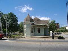
Hopkinsville L & N Railroad Depot |
|
000000001975-08-01-0000August 1, 1975
(#75000745) |
425 E. 9th St.
36°51′49″N 87°29′07″W / 36.863611°N 87.485278°W / 36.863611; -87.485278 (Hopkinsville L & N Railroad Depot) |
Hopkinsville |
|
| 29 |
Hopkinsville Residential Historic District |
|
000000001979-04-30-0000April 30, 1979
(#79003631) |
Roughly bounded by 14th, 20th, Main, and Virginia Sts.; also the southwestern corner of Main and 13th Sts.
36°51′38″N 87°29′30″W / 36.86042°N 87.49166°W / 36.86042; -87.49166 (Hopkinsville Residential Historic District) |
Hopkinsville |
Second address represents a boundary increase
|
| 30 |
Hopkinsville Warehouse Historic District |
|
000000001979-04-30-0000April 30, 1979
(#79003632) |
Roughly along Harrison St. and railroad tracks from 2nd to 21st Sts.
36°51′32″N 87°29′11″W / 36.85878°N 87.48636°W / 36.85878; -87.48636 (Hopkinsville Warehouse Historic District) |
Hopkinsville |
|
| 31 |
Hopper Court |
|
000000001979-04-30-0000April 30, 1979
(#79003605) |
Hopper Ct.
36°51′27″N 87°29′24″W / 36.8575°N 87.49°W / 36.8575; -87.49 (Hopper Court) |
Hopkinsville |
|
| 32 |
J.B. Knight House |
|
000000001979-04-30-0000April 30, 1979
(#79003607) |
1417 E. 7th St.
36°51′32″N 87°29′11″W / 36.858889°N 87.486389°W / 36.858889; -87.486389 (J.B. Knight House) |
Hopkinsville |
|
| 33 |
Lafayette Methodist Church |
Upload image |
000000001979-04-30-0000April 30, 1979
(#79003616) |
Off Kentucky Route 107
36°39′36″N 87°39′33″W / 36.6599°N 87.6592°W / 36.6599; -87.6592 (Lafayette Methodist Church) |
LaFayette |
|
| 34 |
Latham Confederate Monument |
|
000000001997-07-17-0000July 17, 1997
(#97000709) |
Riverside Cemetery, west of Hopkinsville between U.S. Route 41 and L&N railroad tracks.
36°52′31″N 87°28′53″W / 36.875278°N 87.481389°W / 36.875278; -87.481389 (Latham Confederate Monument) |
Hopkinsville |
|
| 35 |
Maplewood |
Upload image |
000000001979-04-30-0000April 30, 1979
(#79003625) |
Off Mason Lane
36°44′21″N 87°20′28″W / 36.739167°N 87.341111°W / 36.739167; -87.341111 (Maplewood) |
Pembroke |
|
| 36 |
McClellen House |
Upload image |
000000001979-04-30-0000April 30, 1979
(#79003621) |
Kentucky Route 508
36°53′13″N 87°20′00″W / 36.886944°N 87.333333°W / 36.886944; -87.333333 (McClellen House) |
Honey Grove |
|
| 37 |
McRay Site (15CH139) |
Upload image |
000000001983-02-03-0000February 3, 1983
(#83002625) |
Address Restricted
|
Hopkinsville |
|
| 38 |
Oakland/Henry House |
Upload image |
000000001979-04-30-0000April 30, 1979
(#79003628) |
Kentucky Route 164
36°49′04″N 87°36′05″W / 36.817778°N 87.601389°W / 36.817778; -87.601389 (Oakland/Henry House) |
Hopkinsville |
|
| 39 |
Pilot Rock Petroglyphs (15CH200) |
Upload image |
000000001989-09-08-0000September 8, 1989
(#89001179) |
Address Restricted
|
Hopkinsville |
|
| 40 |
Poston House |
|
000000001979-04-30-0000April 30, 1979
(#79003608) |
809 Hayes St.
36°52′02″N 87°28′41″W / 36.86709°N 87.47798°W / 36.86709; -87.47798 (Poston House) |
Hopkinsville |
|
| 41 |
Rich Grove |
Upload image |
000000001979-04-30-0000April 30, 1979
(#79003610) |
Off Kentucky Route 109, north of Highway 1027
36°46′22″N 87°26′13″W / 36.772778°N 87.436944°W / 36.772778; -87.436944 (Rich Grove) |
Hopkinsville |
|
| 42 |
Ritter House |
Upload image |
000000001979-04-30-0000April 30, 1979
(#79003609) |
Off U.S. Route 41A
36°49′41″N 87°28′56″W / 36.828056°N 87.482222°W / 36.828056; -87.482222 (Ritter House) |
Hopkinsville |
|
| 43 |
Smokehouse on Riverside Creek |
Upload image |
000000001987-01-08-0000January 8, 1987
(#87000166) |
Petsch Ln. off Kentucky Route 272
36°51′51″N 87°34′50″W / 36.864167°N 87.580556°W / 36.864167; -87.580556 (Smokehouse on Riverside Creek) |
Hopkinsville |
|
| 44 |
Dr. Edward S. Stewart House |
|
000000001979-04-30-0000April 30, 1979
(#79003620) |
U.S. Route 68
36°50′34″N 87°18′10″W / 36.842778°N 87.302778°W / 36.842778; -87.302778 (Dr. Edward S. Stewart House) |
Fairview |
|
| 45 |
E.W. Walker House |
|
000000001983-09-07-0000September 7, 1983
(#83000564) |
1414 E. 7th St.
36°51′52″N 87°28′18″W / 36.864444°N 87.471667°W / 36.864444; -87.471667 (E.W. Walker House) |
Hopkinsville |
|
| 46 |
Western Lunatic Asylum |
|
000000001979-04-30-0000April 30, 1979
(#79003612) |
U.S. Route 68
36°51′54″N 87°27′04″W / 36.865°N 87.451111°W / 36.865; -87.451111 (Western Lunatic Asylum) |
Hopkinsville |
|
| 47 |
Whitepath and Fly Smith Gravesite |
Upload image |
000000002004-11-26-0000November 26, 2004
(#04001250) |
U.S. Route 41[6]
36°51′11″N 87°28′14″W / 36.853056°N 87.470556°W / 36.853056; -87.470556 (Whitepath and Fly Smith Gravesite) |
Hopkinsville |
|
| 48 |
Woodlawn |
Upload image |
000000001979-04-30-0000April 30, 1979
(#79003614) |
Off U.S. Route 41A
36°46′09″N 87°27′38″W / 36.769167°N 87.460556°W / 36.769167; -87.460556 (Woodlawn) |
Hopkinsville |
|
| 49 |
Frank K. Yost House |
|
000000001983-09-07-0000September 7, 1983
(#83000565) |
1131 E. 7th St.
36°51′44″N 87°28′35″W / 36.862222°N 87.476389°W / 36.862222; -87.476389 (Frank K. Yost House) |
Hopkinsville |
|


.jpg)