National Register of Historic Places listings in Chatham County, Georgia
This is a list of properties and districts in Chatham County, Georgia that are listed on the National Register of Historic Places (NRHP).
- This National Park Service list is complete through NPS recent listings posted December 16, 2016.[1]
Current listings
| [2] | Name on the Register | Image | Date listed[3] | Location | City or town | Description |
|---|---|---|---|---|---|---|
| 1 | Ardsley Park-Chatham Crescent Historic District | 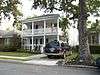 |
(#85001787) |
Roughly bounded by Ardsley Pk., Chatham Crescent, Bull St., Baldwin Pk. and Ardmore 32°02′50″N 81°05′42″W / 32.047222°N 81.095°W |
Savannah | |
| 2 | Bethesda Home for Boys | 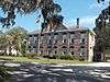 |
(#73000614) |
S of Savannah at Ferguson Ave. and Bethesda Rd. 31°57′49″N 81°05′35″W / 31.963611°N 81.093056°W |
Savannah | |
| 3 | Bonaventure Cemetery |  |
(#01000035) |
Bonaventure Rd., 1 mi. N of US 80 32°02′38″N 81°02′44″W / 32.043889°N 81.045556°W |
Savannah | |
| 4 | Bordley Cottage-Beach View House | _from_ESE_1.JPG) |
(#14000345) |
1701 Butler Ave. 31°59′27″N 80°51′01″W / 31.9909559°N 80.8501883°W |
Tybee Island | |
| 5 | The Carbo House | .jpg) |
(#10000273) |
9 Tybrisa St. 31°59′31″N 80°50′53″W / 31.992011°N 80.847964°W |
Tybee Island | Weekly boarding as of 2016 |
| 6 | Central of Georgia Depot and Trainshed | 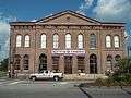 |
(#76000610) |
W. Broad and Liberty Sts. 32°04′34″N 81°05′57″W / 32.07607°N 81.09923°W |
Savannah | Currently the site of the Savannah History Museum |
| 7 | Central of Georgia Railroad: Savannah Shops and Terminal Facilities | 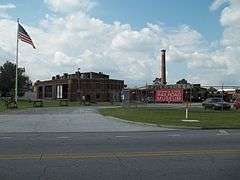 |
(#78000970) |
W. Broad St. and Railroad Ave. 32°04′33″N 81°06′05″W / 32.07571°N 81.10126°W |
Savannah | A National Historic Landmark and currently the home of the Georgia State Railroad Museum; expansion of the Central of Georgia Depot and Trainshed listing |
| 8 | Central of Georgia Railway Company Shop Property | 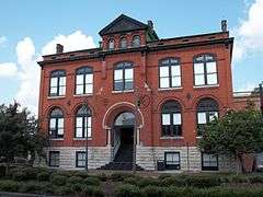 |
(#70000199) |
Between W. Jones St. and Louisville Rd. 32°04′37″N 81°05′56″W / 32.07700°N 81.09881°W |
Savannah | Now an extension of the SCAD Museum of Art |
| 9 | Charity Hospital | 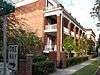 |
(#85000934) |
644 W. 36th St. 32°03′37″N 81°06′29″W / 32.060278°N 81.108056°W |
Savannah | |
| 10 | CSS Georgia (ironclad) | |
(#86003746) |
At the bottom of the Savannah River 32°05′05″N 81°02′09″W / 32.0847°N 81.0358°W |
Savannah | |
| 11 | Cuyler-Brownville Historic District | 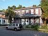 |
(#98000028) |
Roughly bounded by Anderson Ln., W. 31st St., Montgomery St., Victory Dr., Ogeechee Rd., and Hopkins St. 32°03′30″N 81°06′29″W / 32.058333°N 81.108056°W |
Savannah | |
| 12 | Daffin Park-Parkside Place Historic District | 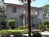 |
(#99000554) |
Bounded by Victory Dr., Waters Ave., Bee St. and 51st Street Ln. 32°02′37″N 81°04′55″W / 32.043611°N 81.081944°W |
Savannah | |
| 13 | Isaiah Davenport House | 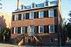 |
(#72000374) |
324 E. State St. 32°04′38″N 81°05′18″W / 32.077222°N 81.088333°W |
Savannah | |
| 14 | Drayton Arms Apartments | _from_SW_1.JPG) |
(#13000826) |
102 E. Liberty St. 32°04′29″N 81°05′31″W / 32.074607°N 81.091956°W |
Savannah | |
| 15 | Drouillard-Maupas House | 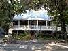 |
(#91000558) |
2422 Abercorn St. 32°03′11″N 81°05′56″W / 32.053056°N 81.098889°W |
Savannah | |
| 16 | Dutton-Waller Raised Tybee Cottage | 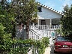 |
(#08000711) |
1416 7th Ave. 31°59′44″N 80°51′13″W / 31.995692°N 80.853719°W |
Tybee Island | |
| 17 | Eastside Historic District | 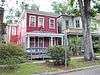 |
(#02001292) |
Roughly bounded by E. Broad, Cedar, Gwinnett and Anderson Sts. 32°03′36″N 81°05′03″W / 32.06°N 81.084167°W |
Savannah | |
| 18 | Eureka Club-Farr's Point | 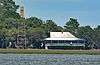 |
(#09000491) |
2326 East Blvd. on Wilmington Island 31°58′18″N 81°00′01″W / 31.97180°N 81.00015°W |
Savannah | |
| 19 | Fairway Oaks-Greenview Historic District |  |
(#09000184) |
Bounded approximately by DeRenne Drive, Waters Avenue, Truman Parkway, and Casey Canal, and the Live Oaks Golf Course 32°01′15″N 81°05′31″W / 32.020711°N 81.092058°W |
Savannah | |
| 20 | Federal Building and U.S. Courthouse | 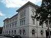 |
(#74000663) |
Wright Sq. 32°04′41″N 81°05′35″W / 32.078056°N 81.093056°W |
Savannah | |
| 21 | First Bryan Baptist Church | 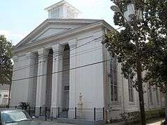 |
(#78000971) |
575 W. Bryan St. 32°04′55″N 81°05′57″W / 32.08208°N 81.09906°W |
Savannah | |
| 22 | Fort James Jackson | 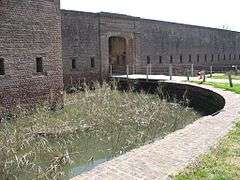 |
(#70000200) |
Islands Expwy. 32°04′55″N 81°02′10″W / 32.081944°N 81.036111°W |
Savannah | National Historic Landmark |
| 23 | Fort Pulaski National Monument | 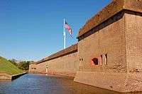 |
(#66000064) |
17 mi. W of Savannah, Cockspur Island 32°01′41″N 80°53′50″W / 32.028056°N 80.897222°W |
Savannah | administered by the National Park Service |
| 24 | Fort Screven Historic District | 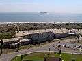 |
(#82002393) |
Tilton, Butler, Van Horn, Railroad and Alger Aves., and Pulaski Rd. 32°01′24″N 80°51′00″W / 32.023333°N 80.85°W |
Tybee Island | |
| 25 | Gordonston Historic District | 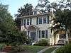 |
(#01000741) |
Roughly bounded by Skidaway Rd., Goebel Ave., Gwinnett St., and Pennsylvania Ave. 32°03′17″N 81°03′47″W / 32.054722°N 81.063056°W |
Savannah | |
| 26 | Green-Meldrim House | 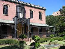 |
(#74000664) |
Macon and Bull Sts. 32°04′26″N 81°05′41″W / 32.073889°N 81.094722°W |
Savannah | National Historic Landmark |
| 27 | Hill Hall at Savannah State College | _from_SE_1.JPG) |
(#81000197) |
Savannah State College campus 32°01′27″N 81°03′23″W / 32.024053°N 81.056475°W |
Savannah | |
| 28 | W. B. Hodgson Hall | 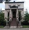 |
(#77000413) |
501 Whitaker St. 32°04′13″N 81°05′49″W / 32.070278°N 81.096944°W |
Savannah | |
| 29 | Isle of Hope Historic District | 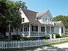 |
(#84003874) |
Roughly bounded by Skidaway River, Parkersburg Rd., Island, Cornus, and Noble Glen Drs. 31°58′49″N 81°03′21″W / 31.980278°N 81.055833°W |
Savannah | |
| 30 | J. Herbert and Julia Johnson Raised Tybee Cottage |  |
(#08000441) |
1306 Jones Ave. 31°59′48″N 80°50′58″W / 31.996703°N 80.849564°W |
Tybee Island | |
| 31 | Kensington Park-Groveland Historic District | .jpg) |
(#14000533) |
Roughly bounded by DeRenne & Waters Aves., Abercorn & Johnston Sts. 32°01′24″N 81°06′12″W / 32.0233°N 81.1033°W |
Savannah[4] | |
| 32 | Laurel Grove-North Cemetery | 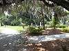 |
(#83000187) |
W. Anderson St. 32°03′53″N 81°06′31″W / 32.064722°N 81.108611°W |
Savannah | |
| 33 | Laurel Grove-South Cemetery | 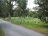 |
(#78000972) |
37th St. 32°03′37″N 81°06′57″W / 32.060278°N 81.115833°W |
Savannah | |
| 34 | Lebanon Plantation | 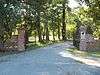 |
(#79000704) |
SW of Savannah 32°00′19″N 81°12′43″W / 32.005278°N 81.211944°W |
Savannah | |
| 35 | Juliette Gordon Low Historic District | 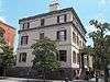 |
(#66000276) |
10 Oglethorpe Ave., E., 330 Drayton St., 329 Abercorn St. 32°04′37″N 81°05′33″W / 32.077062°N 81.092480°W |
Savannah | National Historic Landmark |
| 36 | Massie Common School House | 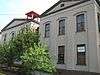 |
(#77000414) |
207 E. Gordon St. 32°04′13″N 81°05′33″W / 32.07020°N 81.09245°W |
Savannah | |
| 37 | Morgan-Ille Cottage |  |
(#08000713) |
703 2nd Ave. 32°00′19″N 80°50′44″W / 32.005211°N 80.845625°W |
Tybee Island | |
| 38 | Mulberry Grove Site | Upload image | (#75000575) |
Address Restricted (305 S Coastal Hwy) 32°11′N 81°10′W / 32.19°N 81.16°W |
Port Wentworth | Left in ruins, reportedly only a marker was left and it is missing[5] |
| 39 | Mulherin-Righton Raised Tybee Cottage | 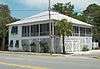 |
(#08000349) |
14 8th Pl. 32°00′10″N 80°50′39″W / 32.002778°N 80.844244°W |
Tybee Island | |
| 40 | New Ogeechee Missionary Baptist Church | 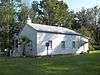 |
(#01000854) |
751 Chevis Rd. 31°58′40″N 81°14′57″W / 31.977778°N 81.249167°W |
Savannah | |
| 41 | Nicholsonville Baptist Church |  |
(#78000969) |
White Bluff Rd. 31°57′30″N 81°08′18″W / 31.958333°N 81.138333°W |
Nicholsonville | |
| 42 | Ossabaw Island | 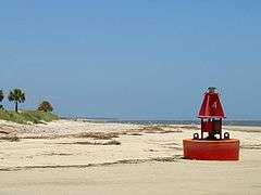 |
(#96000468) |
7 mi. S of Savannah, bounded by the Atlantic Ocean, Bear R., Ogeechee R., and St. Catherine's Sound 31°47′40″N 81°06′44″W / 31.794444°N 81.112222°W |
Savannah | |
| 43 | Owens-Thomas House | 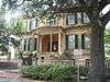 |
(#76000611) |
124 Abercorn St. 32°04′39″N 81°05′22″W / 32.07738°N 81.08940°W |
Savannah | National Historic Landmark |
| 44 | Pine Gardens Historic District | .jpg) |
(#14000890) |
Roughly bounded by Goebel Ave., Beech & Capitol Sts. 32°04′00″N 81°03′23″W / 32.0666°N 81.0565°W |
Savannah | |
| 45 | James and Odessa Rourke, Jr., Raised Tybee Cottage | 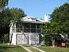 |
(#10000804) |
702 14th St. 31°59′49″N 80°51′10″W / 31.996944°N 80.852778°W |
Tybee Island | |
| 46 | St. Bartholomew's Church |  |
(#82002391) |
Cheves Rd. 31°58′13″N 81°14′42″W / 31.970278°N 81.245°W |
Burroughs | |
| 47 | St. Philip AME Church |  |
(#84000959) |
613 W. Broad St. 32°04′13″N 81°06′05″W / 32.070278°N 81.101389°W |
Savannah | |
| 48 | Savannah and Ogeechee Canal | 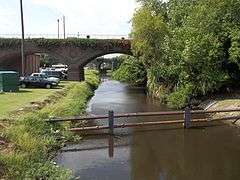 |
(#97000814) |
Roughly along I-95, between the Savannah and Ogeechee Rivers 32°03′40″N 81°13′14″W / 32.061111°N 81.220556°W |
Chatham | |
| 49 | Savannah Historic District | 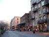 |
(#66000277) |
Bounded by E. Broad, Gwinnett, and W. Broad Sts. and the Savannah River 32°04′28″N 81°05′30″W / 32.074444°N 81.091667°W |
Savannah | National Historic Landmark |
| 50 | Savannah Pharmacy and Fonvielle Office Building | Upload image | (#13000023) |
914-918 Martin Luther King, Jr. Blvd. 32°04′02″N 81°06′08″W / 32.067262°N 81.102112°W |
Savannah | Demolished in 2014[6] |
| 51 | Savannah Victorian Historic District | _(Savannah%2C_Georgia).jpg) |
(#74000665) |
Roughly bounded by Gwinnett, Price, Anderson, and Montgomery Sts.; also the area bounded by Gwinnett, Anderson and 31st Sts. 32°03′53″N 81°05′49″W / 32.064722°N 81.096944°W |
Savannah | Second set of boundaries represents a boundary increase of May 20, 1982 (refnum 82002392) |
| 52 | William Scarbrough House |  |
(#70000201) |
41 W. Broad St. 32°04′52″N 81°05′50″W / 32.08117°N 81.09727°W |
Savannah | National Historic Landmark, now houses the Ships of the Sea Maritime Museum |
| 53 | Sea View Apartments |  |
(#03000286) |
7 18th St. 31°59′27″N 80°51′06″W / 31.990833°N 80.851667°W |
Tybee Island | |
| 54 | Slotin Building |  |
(#83000188) |
101 W. Broad St. 32°04′51″N 81°05′51″W / 32.080833°N 81.0975°W |
Savannah | |
| 55 | Oliver Sturges House |  |
(#71000271) |
27 Abercorn St. 32°04′45″N 81°05′24″W / 32.079167°N 81.09°W |
Savannah | |
| 56 | Telfair Academy | 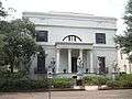 |
(#76000612) |
121 Barnard St. 32°04′44″N 81°05′43″W / 32.078889°N 81.095278°W |
Savannah | National Historic Landmark |
| 57 | Thomas Square Streetcar Historic District | 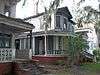 |
(#97000813) |
Roughly bounded by Anderson Ln., 42nd St., Victory Dr., E. Broad St., and Martin Luther King, Jr. Blvd. 32°03′28″N 81°05′56″W / 32.057778°N 81.098889°W |
Savannah | |
| 58 | Two Pierpont Circle |  |
(#90000492) |
2 Pierpont Cir. 32°03′17″N 81°04′01″W / 32.054722°N 81.066944°W |
Savannah | |
| 59 | Tybee Island Back River Historic District | 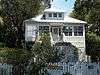 |
(#99000928) |
Along Chatham Ave., from Tybee River to Venetian Dr. 31°59′27″N 80°51′09″W / 31.990833°N 80.8525°W |
Tybee Island | |
| 60 | Tybee Island Strand Cottages Historic District | 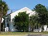 |
(#98000971) |
Selected properties between Butler Ave. and Atlantic Ocean, between 12 St. and 14th St. 31°59′47″N 80°50′49″W / 31.996389°N 80.846944°W |
Tybee Island | |
| 61 | U.S. Customhouse | 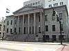 |
(#74000666) |
1-3 E. Bay St. 32°04′50″N 81°05′28″W / 32.08065°N 81.09101°W |
Savannah | |
| 62 | Vernonburg Historic District | 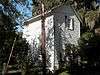 |
(#00000714) |
Dancy Ave., Rockwell Ave. and S. Rockwell Ave. 31°58′19″N 81°07′34″W / 31.971944°N 81.126111°W |
Vernonburg | |
| 63 | Edgar A. Weil House | .jpg) |
(#16000686) |
802 14th St. 31°59′49″N 80°51′14″W / 31.997010°N 80.853959°W |
Tybee Island | |
| 64 | Wild Heron | 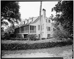 |
(#77000415) |
15 mi. SW of Savannah off U.S. 17; 2148 Grove Point Rd. 31°58′14″N 81°13′08″W / 31.970556°N 81.218889°W |
Savannah | |
| 65 | Wormsloe Plantation | .jpg) |
(#73000615) |
Isle of Hope and Long Island 31°57′53″N 81°04′14″W / 31.964722°N 81.070556°W |
Savannah | Now a Georgia state historic site |
References
- ↑ "National Register of Historic Places: Weekly List Actions". National Park Service, United States Department of the Interior. Retrieved on December 16, 2016.
- ↑ Numbers represent an ordering by significant words. Various colorings, defined here, differentiate National Historic Landmarks and historic districts from other NRHP buildings, structures, sites or objects.
- ↑ The eight-digit number below each date is the number assigned to each location in the National Register Information System database, which can be viewed by clicking the number.
- ↑ Kensington Park, Groveland gain historic status, by Eric Curl, Savannah Morning News, September 23, 2013
- ↑
- ↑ Curl, Eric. "Historic MLK pharmacy demolition begins". Savannah Morning News. 2014-07-30. Retrieved 2015-01-25.
| Wikimedia Commons has media related to National Register of Historic Places in Chatham County, Georgia. |
This article is issued from Wikipedia - version of the 11/21/2016. The text is available under the Creative Commons Attribution/Share Alike but additional terms may apply for the media files.