National Register of Historic Places listings in Charlevoix County, Michigan
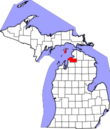
Location of Charlevoix County in Michigan
This is a list of the National Register of Historic Places listings in Charlevoix County, Michigan.
This is intended to be a complete list of the properties and districts on the National Register of Historic Places in Charlevoix County, Michigan, United States. Latitude and longitude coordinates are provided for many National Register properties and districts; these locations may be seen together in a map.[1]
There are 24 properties and districts listed on the National Register in the county.
- This National Park Service list is complete through NPS recent listings posted December 16, 2016.[2]
Current listings
| [3] | Name on the Register[4] | Image | Date listed[5] | Location | City or town | Description |
|---|---|---|---|---|---|---|
| 1 | Beaver Island Light Station | 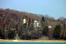 |
(#78001495) |
S of St. James on Beaver Island 45°34′35″N 85°34′21″W / 45.576389°N 85.5725°W |
St. James | |
| 2 | Boyne City Central Historic District | |
(#12001071) |
Water, Pearl, Lake, Ray & Main Sts. 45°12′46″N 85°00′48″W / 45.21278°N 85.0133°W |
Boyne City | |
| 3 | Boyne City Water Works Building | 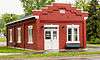 |
(#98001060) |
210 E. Division St. 45°12′17″N 85°00′49″W / 45.204722°N 85.013611°W |
Boyne City | |
| 4 | Charlevoix City Park Site | Upload image | (#72000602) |
Address Restricted |
Charlevoix | |
| 5 | Charlevoix South Pierhead Light |  |
(#05000346) |
S pier at harbor entrance, 0.3 WNW of US 31 drawbridge 45°19′13″N 85°15′54″W / 45.320278°N 85.265°W |
Charlevoix | |
| 6 | Chicago and West Michigan Railroad Charlevoix Station | 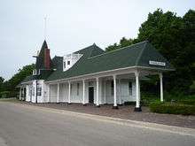 |
(#95001393) |
Chicago Ave. 45°19′03″N 85°14′35″W / 45.3175°N 85.243056°W |
Charlevoix | |
| 7 | East Jordan Lumber Company Store Building | 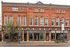 |
(#08000586) |
104 Main St. 45°09′15″N 85°07′39″W / 45.154246°N 85.127563°W |
East Jordan | |
| 8 | Garden Island Indian Cemetery | Upload image | (#78001494) |
Address Restricted |
Charlevoix | |
| 9 | Greensky Hill Mission | 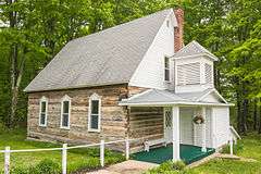 |
(#72000603) |
E of Charlevoix at jct. of US 31 and CR 630 45°19′42″N 85°11′05″W / 45.328333°N 85.184722°W |
Charlevoix | |
| 10 | Horton Bay General Store | 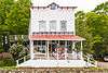 |
(#91001411) |
05115 Boyne City Rd., Bay Township 45°17′06″N 85°04′48″W / 45.285°N 85.08°W |
Horton Bay | |
| 11 | Horton Bay House-Red Fox Inn | 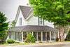 |
(#95000372) |
05156 Boyne City Rd., Bay Township 45°17′06″N 85°04′45″W / 45.285°N 85.079167°W |
Horton Bay | |
| 12 | Horton Bay School | 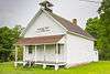 |
(#00001603) |
04991 Boyne City-Charlevoix Rd. 45°17′18″N 85°04′44″W / 45.288333°N 85.078889°W |
Bay Township | |
| 13 | Loeb Farms Barn Complex | |
(#95001392) |
05052 M-66 Hwy. N., SE of Charlevoix, Marion Township 45°16′43″N 85°13′46″W / 45.278611°N 85.229444°W |
Charlevoix | |
| 14 | Mormon Print Shop |  |
(#71000386) |
Main and Forest Sts. 45°44′46″N 85°31′16″W / 45.746111°N 85.521111°W |
St. James | |
| 15 | Mt. McSauba Site | Upload image | (#76001025) |
Address Restricted |
Charlevoix | |
| 16 | O'Neill Site | Upload image | (#71001019) |
Address Restricted |
Charlevoix | |
| 17 | Pewangoing Quarry | Upload image | (#72001471) |
Address Restricted |
Norwood Township | |
| 18 | Pi-wan-go-ning Prehistoric District | Upload image | (#73002153) |
Address Restricted |
Norwood | |
| 19 | Pine River Site | Upload image | (#72001472) |
Address Restricted |
Charlevoix | |
| 20 | John J. and Eva Reynier Porter Estate | 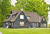 |
(#98000269) |
01787 M-66 S 45°10′44″N 85°09′45″W / 45.178889°N 85.1625°W |
South Arm Township | |
| 21 | Feodar Protar Cabin | 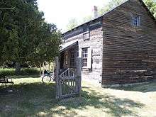 |
(#72000604) |
SW of St. James, on Beaver Island 45°42′13″N 85°33′48″W / 45.703611°N 85.563333°W |
St. James | |
| 22 | Votruba Block | |
(#08000585) |
112 Main St. 45°09′16″N 85°07′39″W / 45.154352°N 85.127521°W |
East Jordan | |
| 23 | Wolverine Hotel | 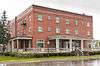 |
(#86000261) |
300 Water St. 45°12′54″N 85°00′58″W / 45.215°N 85.016111°W |
Boyne City | |
| 24 | Wood Site | Upload image | (#76001026) |
Address Restricted |
Charlevoix |
See also
| Wikimedia Commons has media related to National Register of Historic Places in Charlevoix County, Michigan. |
- List of National Historic Landmarks in Michigan
- National Register of Historic Places listings in Michigan
- List of Michigan State Historic Sites in Charlevoix County, Michigan
References
- ↑ The latitude and longitude information provided in this table was derived originally from the National Register Information System, which has been found to be fairly accurate for about 99% of listings. For about 1% of NRIS original coordinates, experience has shown that one or both coordinates are typos or otherwise extremely far off; some corrections may have been made. A more subtle problem causes many locations to be off by up to 150 yards, depending on location in the country: most NRIS coordinates were derived from tracing out latitude and longitudes off of USGS topographical quadrant maps created under the North American Datum of 1927, which differs from the current, highly accurate WGS84 GPS system used by most on-line maps. Chicago is about right, but NRIS longitudes in Washington are higher by about 4.5 seconds, and are lower by about 2.0 seconds in Maine. Latitudes differ by about 1.0 second in Florida. Some locations in this table may have been corrected to current GPS standards.
- ↑ "National Register of Historic Places: Weekly List Actions". National Park Service, United States Department of the Interior. Retrieved on December 16, 2016.
- ↑ Numbers represent an ordering by significant words. Various colorings, defined here, differentiate National Historic Landmarks and historic districts from other NRHP buildings, structures, sites or objects.
- ↑ National Park Service (2008-04-24). "National Register Information System". National Register of Historic Places. National Park Service.
- ↑ The eight-digit number below each date is the number assigned to each location in the National Register Information System database, which can be viewed by clicking the number.
| Topics | |
|---|---|
| Lists by states |
|
| Lists by insular areas | |
| Lists by associated states | |
| Other areas | |
| |
Municipalities and communities of Charlevoix County, Michigan, United States | ||
|---|---|---|
| Cities | | |
| Village | ||
| Townships | ||
| CDPs | ||
This article is issued from Wikipedia - version of the 5/16/2016. The text is available under the Creative Commons Attribution/Share Alike but additional terms may apply for the media files.