| [3] |
Name on the Register[4] |
Image |
Date listed[5] |
Location |
City or town |
Description |
|---|
| 1 |
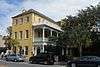
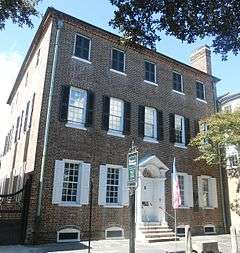
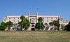
Gov. William Aiken House |
|
000000001979-11-21-0000November 21, 1979
(#77001216) |
48 Elizabeth St.
32°47′29″N 79°56′06″W / 32.7914°N 79.935°W / 32.7914; -79.935 (Gov. William Aiken House) |
Peninsula |
|
| 2 |
William Aiken House and Associated Railroad Structures |
|
000000001966-10-15-0000October 15, 1966
(#66000698) |
456 King St.
32°47′22″N 79°56′17″W / 32.7894°N 79.9381°W / 32.7894; -79.9381 (William Aiken House and Associated Railroad Structures) |
Peninsula |
|
| 3 |
Ashley River Historic District |
|
000000001994-09-12-0000September 12, 1994
(#93001514) |
Roughly along the Ashley River from just east of South Carolina Highway 165 to the Seaboard Coast Line railroad bridge
32°53′58″N 80°07′00″W / 32.8994°N 80.1167°W / 32.8994; -80.1167 (Ashley River Historic District) |
West Ashley |
Extends into other parts of Charleston and into Dorchester counties; boundary increase (listed October 22, 2010): Northwest of Charleston between the northeast bank of the Ashley River and the Ashley-Stono Canal and east of Delmar Highway (Highway 165)
|
| 4 |
Ashley River Road |
|
000000001983-11-21-0000November 21, 1983
(#83003831) |
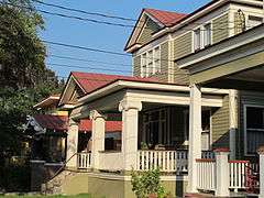
South Carolina Highway 61 between Church Creek and South Carolina Highway 165
32°53′43″N 80°08′08″W / 32.8953°N 80.1356°W / 32.8953; -80.1356 (Ashley River Road) |
West Ashley |
Extends into other parts of Charleston and into Dorchester counties
|
| 5 |
Battery Cheves |
Upload image |
000000001982-08-11-0000August 11, 1982
(#82003841) |
James Island
32°44′17″N 79°54′22″W / 32.7381°N 79.9061°W / 32.7381; -79.9061 (Battery Cheves) |
James Island |
|
| 6 |
Battery LeRoy |
Upload image |
000000001982-08-11-0000August 11, 1982
(#82004786) |
Riverland Dr.
32°42′50″N 79°58′52″W / 32.7139°N 79.9811°W / 32.7139; -79.9811 (Battery LeRoy) |
James Island |
|
| 7 |
Battery No. 1 |
Upload image |
000000001982-08-11-0000August 11, 1982
(#82004787) |
Riverland Dr.
32°42′52″N 79°58′42″W / 32.7144°N 79.9783°W / 32.7144; -79.9783 (Battery No. 1) |
James Island |
|
| 8 |
Battery No. 5 |
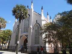
Upload image |
000000001982-08-11-0000August 11, 1982
(#82004788) |
Stonefield Subdivision
32°42′30″N 79°57′18″W / 32.7083°N 79.955°W / 32.7083; -79.955 (Battery No. 5) |
James Island |
|
| 9 |
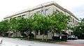
Battery Tynes |
Upload image |
000000001982-08-11-0000August 11, 1982
(#82004789) |
Stono River
32°43′28″N 79°59′23″W / 32.7244°N 79.9897°W / 32.7244; -79.9897 (Battery Tynes) |
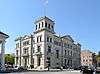
James Island |
|
| 10 |
Battery Wilkes |
Upload image |
000000001982-10-21-0000October 21, 1982
(#82001516) |
St. Andrew's Parish
32°47′38″N 80°03′56″W / 32.7939°N 80.0656°W / 32.7939; -80.0656 (Battery Wilkes) |
West Ashley |
|
| 11 |
Gov. Thomas Bennett House |
|
000000001978-01-31-0000January 31, 1978
(#78002496) |
69 Barre St.
32°46′53″N 79°56′50″W / 32.7814°N 79.9472°W / 32.7814; -79.9472 (Gov. Thomas Bennett House) |
Peninsula |
|
| 12 |
Bethel Methodist Church |
|
000000001974-11-20-0000November 20, 1974
(#74002260) |
57 Pitt St.
32°47′02″N 79°56′29″W / 32.7839°N 79.9414°W / 32.7839; -79.9414 (Bethel Methodist Church) |
Peninsula |
|
| 13 |
William Blacklock House |
|
000000001973-11-07-0000November 7, 1973
(#73001681) |
18 Bull St.
32°47′00″N 79°56′22″W / 32.7833°N 79.9394°W / 32.7833; -79.9394 (William Blacklock House) |
Peninsula |
|
| 14 |
Blake Tenements |
|
000000001970-08-25-0000August 25, 1970
(#70000572) |
2-4 Courthouse Sq.
32°46′36″N 79°55′55″W / 32.7767°N 79.9319°W / 32.7767; -79.9319 (Blake Tenements) |
Peninsula |
|
| 15 |
Branford-Horry House |
|
000000001970-10-15-0000October 15, 1970
(#70000573) |
59 Meeting St.
32°46′28″N 79°55′53″W / 32.7744°N 79.9314°W / 32.7744; -79.9314 (Branford-Horry House) |
Peninsula |
|
| 16 |
Miles Brewton House |
|
000000001966-10-15-0000October 15, 1966
(#66000699) |
27 King St.
32°46′21″N 79°55′59″W / 32.7725°N 79.9331°W / 32.7725; -79.9331 (Miles Brewton House) |
Peninsula |
|
| 17 |
Robert Brewton House |
|
000000001966-10-15-0000October 15, 1966
(#66000700) |
71 Church St.
32°46′28″N 79°55′46″W / 32.7744°N 79.9294°W / 32.7744; -79.9294 (Robert Brewton House) |
Peninsula |
|
| 18 |
Castle Pinckney |
|
000000001970-07-16-0000July 16, 1970
(#70000574) |
Shute's Folly Island
32°46′25″N 79°54′41″W / 32.7736°N 79.9114°W / 32.7736; -79.9114 (Castle Pinckney) |
Shute's Folly Island |
|
| 19 |
Central Baptist Church |
|
000000001977-08-16-0000August 16, 1977
(#77001217) |
26 Radcliffe St.
32°47′18″N 79°56′28″W / 32.7883°N 79.9411°W / 32.7883; -79.9411 (Central Baptist Church) |
Peninsula |
|
| 20 |
Charleston Historic District |
|
000000001966-10-15-0000October 15, 1966
(#66000964) |
An area roughly bounded by Broad, Bay, S. Battery, and Ashley, and an area along Church bounded by Cumberland and Chalmers; also an area roughly bounded by Calhoun, Archdale, Cumberland, E. Battery, Broad, and Gadsden, and an area along Anson St.; also incorporating most of the area south of Bee, Morris, and Mary Sts. to the waterfront; also King and Calhoun Sts.; also 25 and 25½ Warren and 114 St. Phillip Sts.; also 280 E. Bay St.
32°46′47″N 79°56′05″W / 32.7797°N 79.9347°W / 32.7797; -79.9347 (Charleston Historic District) |
Peninsula |
Semicolons separate the original boundaries and boundary increases of 000000001970-01-30-0000January 30, 1970, 000000001978-07-16-0000July 16, 1978, 000000001984-08-02-0000August 2, 1984, 000000001985-08-13-0000August 13, 1985, and 000000001986-03-27-0000March 27, 1986. The increase of 1978 is denominated "Charleston Historic District", and the increases of 1985 and 1986 are denominated "Charleston Old and Historic District".
|
| 21 |
Charleston's French Quarter District |
|
000000001973-09-19-0000September 19, 1973
(#73001682) |
Bounded by Lodge Alley and Cumberland, E. Bay, and State Sts.
32°46′45″N 79°55′41″W / 32.7792°N 79.9281°W / 32.7792; -79.9281 (Charleston's French Quarter District) |
Peninsula |
|
| 22 |
Cigar Factory |
|
000000001980-11-25-0000November 25, 1980
(#80003658) |
Block bounded by East Bay, Columbus, Blake, and Drake Sts.
32°47′52″N 79°56′05″W / 32.7978°N 79.9347°W / 32.7978; -79.9347 (Cigar Factory) |
Peninsula |
|
| 23 |
Circular Congregational Church and Parish House |
|
000000001973-11-07-0000November 7, 1973
(#73001683) |
150 Meeting St.
32°46′44″N 79°55′52″W / 32.7789°N 79.9311°W / 32.7789; -79.9311 (Circular Congregational Church and Parish House) |
Peninsula |
|
| 24 |
Citizens and Southern National Bank of South Carolina |
|
000000001971-05-06-0000May 6, 1971
(#71000747) |
50 Broad St.
32°46′36″N 79°55′48″W / 32.7767°N 79.93°W / 32.7767; -79.93 (Citizens and Southern National Bank of South Carolina) |
Peninsula |
|
| 25 |
College of Charleston |
|
000000001971-11-11-0000November 11, 1971
(#71000748) |
Glebe, George, St. Philip, and Green Sts.
32°47′04″N 79°56′15″W / 32.7844°N 79.9375°W / 32.7844; -79.9375 (College of Charleston) |
Peninsula |
|
| 26 |
Coming Street Cemetery |
|
000000001996-11-05-0000November 5, 1996
(#96001223) |
189 Coming St.
32°47′23″N 79°56′34″W / 32.7897°N 79.9428°W / 32.7897; -79.9428 (Coming Street Cemetery) |
Peninsula |
|
| 27 |
Dock Street Theatre |
|
000000001973-06-19-0000June 19, 1973
(#73001684) |
135 Church St.
32°46′40″N 79°55′48″W / 32.7778°N 79.93°W / 32.7778; -79.93 (Dock Street Theatre) |
Peninsula |
|
| 28 |
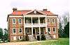
Drayton Hall |
|
000000001966-10-15-0000October 15, 1966
(#66000701) |
12 miles west of Charleston on South Carolina Highway 61
32°52′16″N 80°04′34″W / 32.8711°N 80.0761°W / 32.8711; -80.0761 (Drayton Hall) |
West Ashley |
|
| 29 |
William Enston Home |
|
000000001996-04-25-0000April 25, 1996
(#96000493) |
900 King St.
32°48′06″N 79°56′55″W / 32.8017°N 79.9486°W / 32.8017; -79.9486 (William Enston Home) |
Peninsula |
|
| 30 |
Exchange and Provost |
|
000000001969-12-17-0000December 17, 1969
(#69000160) |
E. Bay and Broad Sts.
32°46′31″N 79°55′38″W / 32.7753°N 79.9272°W / 32.7753; -79.9272 (Exchange and Provost) |
Peninsula |
|
| 31 |
Farmers' and Exchange Bank |
|
000000001973-11-07-0000November 7, 1973
(#73001685) |
141 East Bay Street
32°46′39″N 79°55′38″W / 32.7775°N 79.927222°W / 32.7775; -79.927222 (Farmers' and Exchange Bank) |
Peninsula |
|
| 32 |
Farmfield Plantation House |
Upload image |
000000001982-10-29-0000October 29, 1982
(#82001517) |
Farmfield Rd.
32°46′30″N 79°59′36″W / 32.775°N 79.9933°W / 32.775; -79.9933 (Farmfield Plantation House) |
West Ashley |
|
| 33 |
Fenwick Hall |
|
000000001972-02-23-0000February 23, 1972
(#72001196) |
South of Charleston on Johns Island, U.S. Route 17
32°45′02″N 80°02′20″W / 32.7506°N 80.0389°W / 32.7506; -80.0389 (Fenwick Hall) |
Johns Island |
|
| 34 |
Fireproof Building |
|
000000001969-07-29-0000July 29, 1969
(#69000161) |
100 Meeting St.
32°46′36″N 79°55′55″W / 32.7767°N 79.9319°W / 32.7767; -79.9319 (Fireproof Building) |
Peninsula |
|
| 35 |
Florence Crittenton Home |
|
000000001997-09-25-0000September 25, 1997
(#97001157) |
19 St. Margaret St.
32°48′12″N 79°57′18″W / 32.8033°N 79.955°W / 32.8033; -79.955 (Florence Crittenton Home) |
Peninsula |
|
| 36 |
Fort Pringle |
Upload image |
000000001982-08-11-0000August 11, 1982
(#82004790) |
Riverland Dr.
32°42′50″N 79°59′07″W / 32.7139°N 79.9853°W / 32.7139; -79.9853 (Fort Pringle) |
James Island |
|
| 37 |
Fort Sumter National Monument |
|
000000001966-01-15-0000January 15, 1966
(#66000101) |
Charleston Harbor
32°45′08″N 79°52′29″W / 32.7522°N 79.8747°W / 32.7522; -79.8747 (Fort Sumter National Monument) |
Harbor |
|
| 38 |
Fort Trenholm |
Upload image |
000000001982-08-11-0000August 11, 1982
(#82004791) |
Johns Island Airport
32°42′29″N 79°59′49″W / 32.7081°N 79.9969°W / 32.7081; -79.9969 (Fort Trenholm) |
Johns Island |
|
| 39 |
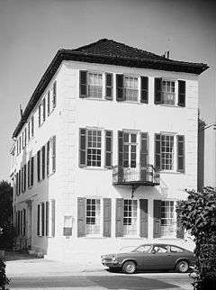
William Gibbes House |
|
000000001970-04-15-0000April 15, 1970
(#70000575) |
64 S. Battery
32°46′14″N 79°55′59″W / 32.7706°N 79.9331°W / 32.7706; -79.9331 (William Gibbes House) |
Peninsula |
|
| 40 |
Greek Orthodox Church of the Holy Trinity |
|
000000002004-10-22-0000October 22, 2004
(#04001164) |
30 Race St.
32°47′52″N 79°56′55″W / 32.7978°N 79.9486°W / 32.7978; -79.9486 (Greek Orthodox Church of the Holy Trinity) |
Peninsula |
|
| 41 |
Hampton Park Terrace Historic District |
|
000000001997-09-26-0000September 26, 1997
(#97001186) |
Roughly bounded by Hagood and Rutledge Aves., and Moltrie and Congress Sts.
32°47′48″N 79°57′19″W / 32.7967°N 79.9553°W / 32.7967; -79.9553 (Hampton Park Terrace Historic District) |
Peninsula |
|
| 42 |
Dubose Heyward House |
|
000000001971-11-11-0000November 11, 1971
(#71000749) |
76 Church St.
32°46′26″N 79°55′44″W / 32.7739°N 79.9289°W / 32.7739; -79.9289 (Dubose Heyward House) |
Peninsula |
|
| 43 |
Heyward-Washington House |
|
000000001970-04-15-0000April 15, 1970
(#70000576) |
87 Church St.
32°46′33″N 79°55′46″W / 32.7758°N 79.9294°W / 32.7758; -79.9294 (Heyward-Washington House) |
Peninsula |
|
| 44 |
Hibernian Hall |
|
000000001973-11-07-0000November 7, 1973
(#73001686) |
105 Meeting St.
32°46′38″N 79°55′54″W / 32.7772°N 79.9317°W / 32.7772; -79.9317 (Hibernian Hall) |
Peninsula |
|
| 45 |
Cleland Kinloch and Burnet R. Maybank Huger House |
Upload image |
000000002015-10-05-0000October 5, 2015
(#15000705) |
8 Legare St.
32°46′20″N 79°56′02″W / 32.7722°N 79.9338°W / 32.7722; -79.9338 (Cleland Kinloch and Burnet R. Maybank Huger House) |
|
|
| 46 |
Huguenot Church |
|
000000001973-11-07-0000November 7, 1973
(#73001687) |
136 Church St.
32°46′50″N 79°55′45″W / 32.7806°N 79.9292°W / 32.7806; -79.9292 (Huguenot Church) |
Peninsula |
|
| 47 |
Kahal Kadosh Beth Elohim Synagogue |
|
000000001978-04-04-0000April 4, 1978
(#78002499) |
90 Hasell St.
32°46′56″N 79°55′58″W / 32.7822°N 79.9328°W / 32.7822; -79.9328 (Kahal Kadosh Beth Elohim Synagogue) |
Peninsula |
|
| 48 |
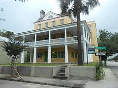
Lowndes Grove |
|
000000001978-08-30-0000August 30, 1978
(#78002500) |
260 St. Margaret St.
32°48′06″N 79°57′58″W / 32.8017°N 79.9661°W / 32.8017; -79.9661 (Lowndes Grove) |
Peninsula |
|
| 49 |
Jonathan Lucas House |
|
000000001978-02-23-0000February 23, 1978
(#78002501) |
286 Calhoun St.
32°46′57″N 79°56′54″W / 32.7825°N 79.9483°W / 32.7825; -79.9483 (Jonathan Lucas House) |
Peninsula |
|
| 50 |
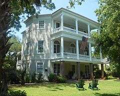
Magnolia Cemetery |
|
000000001978-03-24-0000March 24, 1978
(#78002502) |
North of Charleston off U.S. Route 52
32°49′06″N 79°56′32″W / 32.8183°N 79.9422°W / 32.8183; -79.9422 (Magnolia Cemetery) |
Peninsula |
|
| 51 |
Joseph Manigault House |
|
000000001973-11-07-0000November 7, 1973
(#73001688) |
350 Meeting St.
32°47′19″N 79°56′08″W / 32.7886°N 79.9356°W / 32.7886; -79.9356 (Joseph Manigault House) |
Peninsula |
|
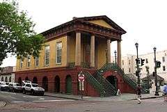
| 52 |
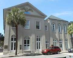
Market Hall and Sheds |
|
000000001973-06-04-0000June 4, 1973
(#73001689) |
188 Meeting St.
32°46′49″N 79°55′53″W / 32.7803°N 79.9314°W / 32.7803; -79.9314 (Market Hall and Sheds) |
Peninsula |
Also known as the Old City Market; market stalls are located on the first story of Market Hall, and continue in a series of sheds stretching behind Market Hall all the way to E. Bay St.
|
| 53 |
McCrady's Tavern and Long Room |
|
000000001972-09-14-0000September 14, 1972
(#72001199) |
153 E. Bay St.
32°46′41″N 79°55′38″W / 32.7781°N 79.9272°W / 32.7781; -79.9272 (McCrady's Tavern and Long Room) |
Peninsula |
|
| 54 |
McLeod Plantation |
|
000000001974-08-13-0000August 13, 1974
(#74001831) |
325 Country Club Dr.
32°45′46″N 79°58′21″W / 32.7628°N 79.9725°W / 32.7628; -79.9725 (McLeod Plantation) |
James Island |
|
| 55 |
Isaac Jenkins Mikell House |
|
000000002014-03-11-0000March 11, 2014
(#14000056) |
94 Rutledge Ave.
32°46′51″N 79°56′31″W / 32.780825°N 79.94205°W / 32.780825; -79.94205 (Isaac Jenkins Mikell House) |
Peninsula |
|
| 56 |
Clark Mills Studio |
|
000000001966-10-15-0000October 15, 1966
(#66000703) |
51 Broad St.
32°46′34″N 79°55′48″W / 32.7761°N 79.93°W / 32.7761; -79.93 (Clark Mills Studio) |
Peninsula |
A studio of the self-taught sculptor Clark Mills on Broad Street.
|
| 57 |
Morris Island Lighthouse |
|
000000001982-06-28-0000June 28, 1982
(#82003837) |
6 miles (10 km) southeast of Charleston
32°41′43″N 79°53′01″W / 32.695278°N 79.883611°W / 32.695278; -79.883611 (Morris Island Lighthouse) |
Morris Island |
|
| 58 |
Andrew B. Murray Vocational School |
|
000000002002-05-30-0000May 30, 2002
(#02000569) |
3 Chisolm St.
32°46′26″N 79°56′33″W / 32.7739°N 79.9425°W / 32.7739; -79.9425 (Andrew B. Murray Vocational School) |
Peninsula |
|
| 59 |
James Nicholson House |
|
000000001974-08-30-0000August 30, 1974
(#74001832) |
172 Rutledge Ave.
32°47′12″N 79°56′44″W / 32.7867°N 79.9456°W / 32.7867; -79.9456 (James Nicholson House) |
Peninsula |
|
| 60 |
Old Bethel United Methodist Church |
|
000000001975-04-21-0000April 21, 1975
(#75001693) |
222 Calhoun St.
32°47′03″N 79°56′33″W / 32.7842°N 79.9425°W / 32.7842; -79.9425 (Old Bethel United Methodist Church) |
Peninsula |
|
| 61 |
Old Marine Hospital |
|
000000001973-11-07-0000November 7, 1973
(#73001690) |
20 Franklin St.
32°46′40″N 79°56′14″W / 32.7778°N 79.9372°W / 32.7778; -79.9372 (Old Marine Hospital) |
Peninsula |
|
| 62 |
Old Slave Mart |
|
000000001975-05-02-0000May 2, 1975
(#75001694) |
6 Chalmers St.
32°46′38″N 79°55′48″W / 32.7772°N 79.93°W / 32.7772; -79.93 (Old Slave Mart) |
Peninsula |
|
| 63 |
Porter Military Academy |
|
000000001996-06-21-0000June 21, 1996
(#96000685) |
175-181 Ashley Ave.
32°47′12″N 79°56′52″W / 32.7867°N 79.9478°W / 32.7867; -79.9478 (Porter Military Academy) |
Peninsula |
|
| 64 |
Powder Magazine |
|
000000001972-01-05-0000January 5, 1972
(#72001200) |
79 Cumberland St.
32°46′45″N 79°55′51″W / 32.7792°N 79.9308°W / 32.7792; -79.9308 (Powder Magazine) |
Peninsula |
|
| 65 |
Presqui'ile |
|
000000001978-12-08-0000December 8, 1978
(#78002503) |
2 Amherst St.
32°47′43″N 79°56′00″W / 32.795278°N 79.933333°W / 32.795278; -79.933333 (Presqui'ile) |
Peninsula |
|
| 66 |
Robert Barnwell Rhett House |
|
000000001973-11-07-0000November 7, 1973
(#73001691) |
6 Thomas St.
32°47′10″N 79°56′33″W / 32.7861°N 79.9425°W / 32.7861; -79.9425 (Robert Barnwell Rhett House) |
Peninsula |
|
| 67 |
William Robb House |
|
000000001983-09-08-0000September 8, 1983
(#83002186) |
12 Bee St.
32°47′14″N 79°56′50″W / 32.7872°N 79.9472°W / 32.7872; -79.9472 (William Robb House) |
Peninsula |
|
| 68 |
Robert William Roper House |
|
000000001973-11-07-0000November 7, 1973
(#73001692) |
9 E. Battery St.
32°46′15″N 79°55′43″W / 32.7708°N 79.9286°W / 32.7708; -79.9286 (Robert William Roper House) |
Peninsula |
|
| 69 |
Thomas Rose House |
|
000000001970-10-15-0000October 15, 1970
(#70000892) |
57-59 Church St.
32°46′24″N 79°55′46″W / 32.7733°N 79.9294°W / 32.7733; -79.9294 (Thomas Rose House) |
Peninsula |
|
| 70 |
Nathaniel Russell House |
|
000000001971-08-19-0000August 19, 1971
(#71000750) |
51 Meeting St.
32°46′26″N 79°55′53″W / 32.7739°N 79.9314°W / 32.7739; -79.9314 (Nathaniel Russell House) |
Peninsula |
|
| 71 |
Edward Rutledge House |
|
000000001971-11-11-0000November 11, 1971
(#71000751) |
117 Broad St.
32°46′34″N 79°56′02″W / 32.7761°N 79.9339°W / 32.7761; -79.9339 (Edward Rutledge House) |
Peninsula |
|
| 72 |
Gov. John Rutledge House |
|
000000001971-11-07-0000November 7, 1971
(#71000752) |
116 Broad St.
32°46′34″N 79°56′01″W / 32.7761°N 79.9336°W / 32.7761; -79.9336 (Gov. John Rutledge House) |
Peninsula |
|
| 73 |
St. Andrew's Episcopal Church |
|
000000001973-10-15-0000October 15, 1973
(#73001694) |
5 miles northwest of Charleston on South Carolina Highway 61
32°50′19″N 80°02′57″W / 32.8386°N 80.0492°W / 32.8386; -80.0492 (St. Andrew's Episcopal Church) |
West Ashley |
|
| 74 |
St. Mary's Roman Catholic Church |
|
000000001976-11-07-0000November 7, 1976
(#76001697) |
93 Hasell St.
32°46′54″N 79°55′58″W / 32.7817°N 79.9328°W / 32.7817; -79.9328 (St. Mary's Roman Catholic Church) |
Peninsula |
|
| 75 |
St. Michael's Episcopal Church |
|
000000001966-10-15-0000October 15, 1966
(#66000704) |
80 Meeting St.
32°46′34″N 79°55′51″W / 32.7761°N 79.9308°W / 32.7761; -79.9308 (St. Michael's Episcopal Church) |
Peninsula |
|
| 76 |
St. Philip's Episcopal Church |
|
000000001973-11-07-0000November 7, 1973
(#73001695) |
146 Church St.
32°46′45″N 79°55′45″W / 32.7792°N 79.9292°W / 32.7792; -79.9292 (St. Philip's Episcopal Church) |
Peninsula |
|
| 77 |
Secessionville Historic District |
|
000000001979-10-01-0000October 1, 1979
(#79002378) |
North of Folly Beach
32°42′18″N 79°56′35″W / 32.705°N 79.9431°W / 32.705; -79.9431 (Secessionville Historic District) |
James Island |
Extends into Folly Beach, elsewhere in Charleston County
|
| 78 |
Simmons-Edwards House |
|
000000001971-01-25-0000January 25, 1971
(#71000753) |
12-14 Legare St.
32°46′21″N 79°56′03″W / 32.7725°N 79.9342°W / 32.7725; -79.9342 (Simmons-Edwards House) |
Peninsula |
|
| 79 |
Site of Old Charles Towne |
|
000000001969-12-17-0000December 17, 1969
(#69000162) |
Albemarle Point
32°48′27″N 79°59′13″W / 32.8075°N 79.9869°W / 32.8075; -79.9869 (Site of Old Charles Towne) |
West Ashley |
Now part of a state historic site
|
| 80 |
South Carolina National Bank of Charleston |
|
000000001973-06-04-0000June 4, 1973
(#73001693) |
16 Broad St.
32°46′37″N 79°55′39″W / 32.7769°N 79.9275°W / 32.7769; -79.9275 (South Carolina National Bank of Charleston) |
Peninsula |
|
| 81 |
South Carolina State Arsenal |
|
000000001970-07-16-0000July 16, 1970
(#70000577) |
2 Tobacco Street, Marion Square
32°47′14″N 79°56′11″W / 32.787222°N 79.936389°W / 32.787222; -79.936389 (South Carolina State Arsenal) |
Peninsula |
|
| 82 |
James Sparrow House |
|
000000001998-01-30-0000January 30, 1998
(#98000045) |
65 Cannon St.
32°47′20″N 79°56′42″W / 32.7889°N 79.945°W / 32.7889; -79.945 (James Sparrow House) |
Peninsula |
|
| 83 |
Standard Oil Company Headquarters |
|
000000002015-02-03-0000February 3, 2015
(#14001243) |
1600 Meeting St.
32°49′18″N 79°57′05″W / 32.8216°N 79.9513°W / 32.8216; -79.9513 (Standard Oil Company Headquarters) |
|
|
| 84 |
Stiles-Hinson House |
Upload image |
000000001974-10-09-0000October 9, 1974
(#74001833) |
940 Paul Revere Dr.
32°45′06″N 79°55′45″W / 32.7517°N 79.9292°W / 32.7517; -79.9292 (Stiles-Hinson House) |
James Island |
|
| 85 |
Col. John Stuart House |
|
000000001970-10-22-0000October 22, 1970
(#70000578) |
104-106 Tradd St.
32°46′27″N 79°56′01″W / 32.7742°N 79.9336°W / 32.7742; -79.9336 (Col. John Stuart House) |
Peninsula |
|
| 86 |
Sword Gate House |
|
000000001970-12-18-0000December 18, 1970
(#70000579) |
32 Legare St. and 111 Tradd St.
32°46′25″N 79°56′03″W / 32.7736°N 79.9342°W / 32.7736; -79.9342 (Sword Gate House) |
Peninsula |
|
| 87 |
Josiah Smith Tennent House |
|
000000001979-11-27-0000November 27, 1979
(#79002377) |
729 E. Bay St.
32°47′55″N 79°56′06″W / 32.7986°N 79.935°W / 32.7986; -79.935 (Josiah Smith Tennent House) |
Peninsula |
|
| 88 |
U.S. Customhouse |
|
000000001974-10-09-0000October 9, 1974
(#74001834) |
200 E. Bay St.
32°46′50″N 79°55′37″W / 32.7806°N 79.9269°W / 32.7806; -79.9269 (U.S. Customhouse) |
Peninsula |
|
| 89 |
U.S. Post Office and Courthouse |
|
000000001974-08-13-0000August 13, 1974
(#74001835) |
83 Broad Street
32°46′33″N 79°55′54″W / 32.775833°N 79.931667°W / 32.775833; -79.931667 (U.S. Post Office and Courthouse) |
Peninsula |
|
| 90 |
Unitarian Church |
|
000000001973-11-07-0000November 7, 1973
(#73001696) |
6 Archdale St.
32°46′20″N 79°56′02″W / 32.7722°N 79.9339°W / 32.7722; -79.9339 (Unitarian Church) |
Peninsula |
|
| 91 |
Unnamed Battery |
Upload image |
000000001982-08-11-0000August 11, 1982
(#82003846) |
St. Andrew
32°48′07″N 80°03′14″W / 32.8019°N 80.0539°W / 32.8019; -80.0539 (Unnamed Battery) |
West Ashley |
|
| 92 |
Denmark Vesey House |
|
000000001976-05-11-0000May 11, 1976
(#76001698) |
56 Bull St.
32°46′56″N 79°56′28″W / 32.7822°N 79.9411°W / 32.7822; -79.9411 (Denmark Vesey House) |
Peninsula |
|
| 93 |
West Point Rice Mill |
|
000000001995-01-20-0000January 20, 1995
(#94001569) |
Junction of Lockwood Dr. and Calhoun St.
32°46′44″N 79°57′04″W / 32.7789°N 79.9511°W / 32.7789; -79.9511 (West Point Rice Mill) |
Peninsula |
|


.jpg)
.jpg)


_1.jpg)
.jpg)


.jpg)


.jpg)


.jpg)


_2.jpg)
.jpg)


%2C_Saint_Margaret_Street_%26_Sixth_Avenue%2C_Charleston_(Charleston_County%2C_South_Carolina).jpg)
.jpg)
.jpg)


.jpg)


.jpg)
.jpg)
.jpg)

.jpg)


.JPG)
.jpg)
.jpg)
.jpg)


.jpg)


.jpg)
.jpg)

.jpg)