National Register of Historic Places listings in Cedar County, Iowa
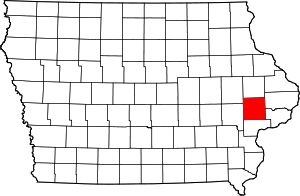
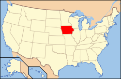
Location of Cedar County in Iowa
This is a list of the National Register of Historic Places listings in Cedar County, Iowa.
This is intended to be a complete list of the properties and districts on the National Register of Historic Places in Cedar County, Iowa, United States. Latitude and longitude coordinates are provided for many National Register properties and districts; these locations may be seen together in a map.[1]
There are 17 properties and districts listed on the National Register in the county, including 1 National Historic Landmark.
- This National Park Service list is complete through NPS recent listings posted December 16, 2016.[2]
Current listings
| [3] |
Name on the Register[4] |
Image |
Date listed[5] |
Location |
City or town |
Description |
|---|
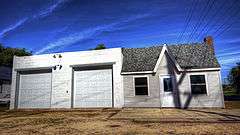
| 1 |
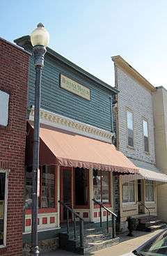
Cedar County Sheriff's House and Jail |
|
000000002003-09-13-0000September 13, 2003
(#03000913) |
118 W. 4th St.
41°46′09″N 91°07′45″W / 41.769167°N 91.129167°W / 41.769167; -91.129167 (Cedar County Sheriff's House and Jail) |
Tipton |
|
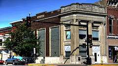
| 2 |
Downey Savings Bank |
|
000000001976-07-12-0000July 12, 1976
(#76000740) |
Front St.
41°36′57″N 91°20′58″W / 41.615833°N 91.349444°W / 41.615833; -91.349444 (Downey Savings Bank) |
Downey |
|
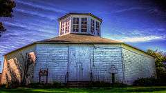
| 3 |
Floral Hall |
|
000000001976-11-07-0000November 7, 1976
(#76000741) |
West of Tipton at the Cedar County Fairgrounds
41°46′25″N 91°08′38″W / 41.773611°N 91.143889°W / 41.773611; -91.143889 (Floral Hall) |
Tipton |
|
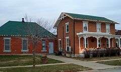
| 4 |
William Green House |
|
000000001999-04-29-0000April 29, 1999
(#99000488) |
1709 Madison St.
41°40′26″N 91°09′43″W / 41.673889°N 91.161944°W / 41.673889; -91.161944 (William Green House) |
Rochester |
|
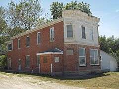
| 5 |
Gruwell and Crew General Store |
|
000000001982-09-09-0000September 9, 1982
(#82002610) |
109 W. Main St.
41°40′05″N 91°20′49″W / 41.668056°N 91.346944°W / 41.668056; -91.346944 (Gruwell and Crew General Store) |
West Branch |
On the Most Endangered list of the Iowa Historic Preservation Alliance[6]
|
| 6 |
Hannah Morse Fowler Hall House |
Upload image |
000000001998-05-01-0000May 1, 1998
(#98000378) |
1285 Garfield Ave.
41°45′32″N 91°15′15″W / 41.758889°N 91.254167°W / 41.758889; -91.254167 (Hannah Morse Fowler Hall House) |
Buchanan |
|
| 7 |
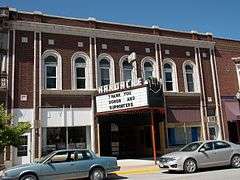
Hardacre Theater |
|
000000002016-01-05-0000January 5, 2016
(#15000951) |
112 E. 5th St.
41°46′13″N 91°07′40″W / 41.770254°N 91.127852°W / 41.770254; -91.127852 (Hardacre Theater) |
Tipton |
|
| 8 |
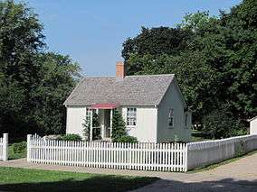
Herbert Hoover National Historic Site |
|
000000001966-10-15-0000October 15, 1966
(#66000110) |
Off Interstate 80
41°40′05″N 91°20′58″W / 41.668056°N 91.349444°W / 41.668056; -91.349444 (Herbert Hoover National Historic Site) |
West Branch |
|
| 9 |
Hotel Tipton |
|
000000001998-11-05-0000November 5, 1998
(#98001328) |
524-527 Cedar St.
41°46′15″N 91°07′43″W / 41.770833°N 91.128611°W / 41.770833; -91.128611 (Hotel Tipton) |
Tipton |
|
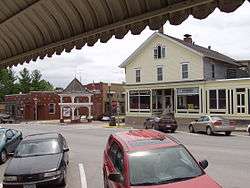
| 10 |
Kreinbring Phillips 66 Gas Station |
|
000000002000-08-10-0000August 10, 2000
(#00000933) |
200 Main St.
41°51′28″N 90°55′13″W / 41.857778°N 90.920278°W / 41.857778; -90.920278 (Kreinbring Phillips 66 Gas Station) |
Lowden |
|
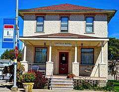
| 11 |
Lincoln Hotel |
|
000000001996-06-28-0000June 28, 1996
(#96000699) |
408 Main St.
41°51′28″N 90°55′35″W / 41.857778°N 90.926389°W / 41.857778; -90.926389 (Lincoln Hotel) |
Lowden |
|
| 12 |
Mill Creek Bridge |
|
000000001998-06-25-0000June 25, 1998
(#98000743) |
Plum St. over Mill Creek
41°54′15″N 91°03′53″W / 41.904167°N 91.064722°W / 41.904167; -91.064722 (Mill Creek Bridge) |
Clarence |
|
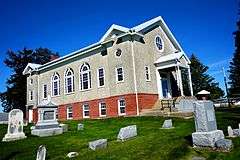
| 13 |
Red Oak Grove Presbyterian Church and Cemetery |
|
000000002010-02-03-0000February 3, 2010
(#09001302) |
751 King Ave.
41°50′09″N 91°09′25″W / 41.835947°N 91.157072°W / 41.835947; -91.157072 (Red Oak Grove Presbyterian Church and Cemetery) |
Tipton |
|
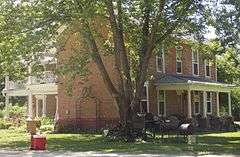
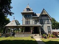
| 14 |
John Christian and Bertha Landrock Reichert House |
|
000000001991-12-19-0000December 19, 1991
(#91001861) |
508 E. 4th St.
41°46′09″N 91°07′13″W / 41.769167°N 91.120278°W / 41.769167; -91.120278 (John Christian and Bertha Landrock Reichert House) |
Tipton |
|
| 15 |
St. Paul's Episcopal Church and Parish Hall |
|
000000001985-01-03-0000January 3, 1985
(#85000002) |
206 6th Ave.
41°35′55″N 90°54′46″W / 41.598611°N 90.912778°W / 41.598611; -90.912778 (St. Paul's Episcopal Church and Parish Hall) |
Durant |
|
| 16 |
Tipton State Bank |
|
000000002000-09-14-0000September 14, 2000
(#00001075) |
501 Cedar St.
41°46′13″N 91°07′42″W / 41.770278°N 91.128333°W / 41.770278; -91.128333 (Tipton State Bank) |
Tipton |
|
| 17 |
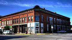
West Branch Commercial Historic District |
|
000000001987-04-07-0000April 7, 1987
(#90000158) |
W. Main and N. Downey Sts.; also N. Downey and E. and W. Main Sts.; also 124 W. Main St.
41°40′23″N 91°20′54″W / 41.673056°N 91.348333°W / 41.673056; -91.348333 (West Branch Commercial Historic District) |
West Branch |
Second and third sets of addresses represent boundary increases |
See also
References
- ↑ The latitude and longitude information provided in this table was derived originally from the National Register Information System, which has been found to be fairly accurate for about 99% of listings. For about 1% of NRIS original coordinates, experience has shown that one or both coordinates are typos or otherwise extremely far off; some corrections may have been made. A more subtle problem causes many locations to be off by up to 150 yards, depending on location in the country: most NRIS coordinates were derived from tracing out latitude and longitudes off of USGS topographical quadrant maps created under the North American Datum of 1927, which differs from the current, highly accurate WGS84 GPS system used by most on-line maps. Chicago is about right, but NRIS longitudes in Washington are higher by about 4.5 seconds, and are lower by about 2.0 seconds in Maine. Latitudes differ by about 1.0 second in Florida. Some locations in this table may have been corrected to current GPS standards.
- ↑ "National Register of Historic Places: Weekly List Actions". National Park Service, United States Department of the Interior. Retrieved on December 16, 2016.
- ↑ Numbers represent an ordering by significant words. Various colorings, defined here, differentiate National Historic Landmarks and historic districts from other NRHP buildings, structures, sites or objects.
- ↑ National Park Service (2008-04-24). "National Register Information System". National Register of Historic Places. National Park Service.
- ↑ The eight-digit number below each date is the number assigned to each location in the National Register Information System database, which can be viewed by clicking the number.
- ↑ Iowa's Most Endangered Properties, http://www.iowapreservation.org/endangered.php
|
|---|
|
| Topics | |
|---|
|
| Lists by states | |
|---|
|
| Lists by insular areas | |
|---|
|
| Lists by associated states | |
|---|
|
| Other areas | |
|---|
|
-
 Portal Portal
-
 WikiProject WikiProject
|