| [3] |
Name on the Register[4] |
Image |
Date listed[5] |
Location |
City or town |
Description |
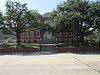
|---|
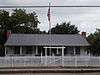
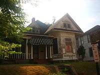
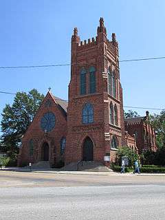
| 1 |
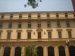
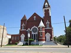
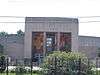
Antioch Baptist Church |
|
000000001982-11-01-0000November 1, 1982
(#82000431) |
1057 Texas Ave.
32°30′13″N 93°45′12″W / 32.503611°N 93.753333°W / 32.503611; -93.753333 (Antioch Baptist Church) |
Shreveport |
|
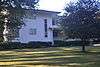
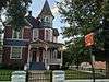
| 2 |
C.C. Antoine House |
|
000000001999-08-20-0000August 20, 1999
(#99001013) |
1941 Perrin St.
32°30′34″N 93°46′13″W / 32.509444°N 93.770278°W / 32.509444; -93.770278 (C.C. Antoine House) |
Shreveport |
|
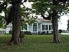
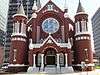
| 3 |
B'Nai Zion Temple |
|
000000001994-01-21-0000January 21, 1994
(#93001547) |
802 Cotton St.
32°30′30″N 93°45′01″W / 32.508333°N 93.750278°W / 32.508333; -93.750278 (B'Nai Zion Temple) |
Shreveport |
|
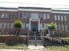
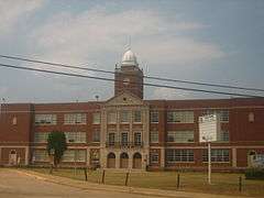
| 4 |
C. E. Byrd High School |
|
000000001991-06-10-0000June 10, 1991
(#91000704) |
3201 Line Ave.
32°28′49″N 93°44′43″W / 32.480278°N 93.745278°W / 32.480278; -93.745278 (C. E. Byrd High School) |
Shreveport |
|
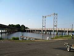
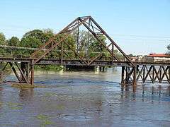
| 5 |
Caddo Lake Bridge |
|
000000001996-10-18-0000October 18, 1996
(#96001166) |
Louisiana Highway 538 over Caddo Lake
32°41′46″N 93°57′29″W / 32.696111°N 93.958056°W / 32.696111; -93.958056 (Caddo Lake Bridge) |
Mooringsport |
|
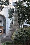
| 6 |
Caddo Parish Confederate Monument |
|
000000002014-01-29-0000January 29, 2014
(#13001124) |
501 Texas Ave.
32°30′45″N 93°45′00″W / 32.512376°N 93.749998°W / 32.512376; -93.749998 (Caddo Parish Confederate Monument) |
Shreveport |
|
| 7 |
Caspiana House |
|
000000001981-12-10-0000December 10, 1981
(#81000288) |
Louisiana State University campus
32°26′14″N 93°42′28″W / 32.437222°N 93.707778°W / 32.437222; -93.707778 (Caspiana House) |
Shreveport |
|
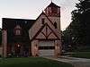
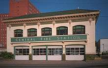
| 8 |
Central Fire Station |
|
000000001991-05-28-0000May 28, 1991
(#91000625) |
801 Crockett St.
32°30′31″N 93°45′03″W / 32.508611°N 93.750833°W / 32.508611; -93.750833 (Central Fire Station) |
Shreveport |
|
| 9 |
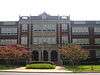
Central High School |
|
000000001991-05-16-0000May 16, 1991
(#91000606) |
1627 Weinstock St.
32°30′01″N 93°45′51″W / 32.500278°N 93.764167°W / 32.500278; -93.764167 (Central High School) |
Shreveport |
|
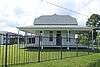
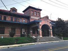
| 10 |
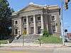
Central Railroad Station |
|
000000001991-05-28-0000May 28, 1991
(#91000622) |
1025 Marshall St.
32°30′32″N 93°44′43″W / 32.508889°N 93.745278°W / 32.508889; -93.745278 (Central Railroad Station) |
Shreveport |
|
| 11 |
Crystal Grocery |
Upload image |
000000001998-03-05-0000March 5, 1998
(#98000181) |
1124 Fairfield
32°30′12″N 93°45′01″W / 32.503333°N 93.750278°W / 32.503333; -93.750278 (Crystal Grocery) |
Shreveport |
|
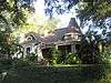
| 12 |
Davidson House |
|
000000001983-12-22-0000December 22, 1983
(#83003604) |
654 Wichita Ave.
32°29′40″N 93°44′34″W / 32.494444°N 93.742778°W / 32.494444; -93.742778 (Davidson House) |
Shreveport |
|
| 13 |
Dodd College President's Home |
|
000000001982-07-22-0000July 22, 1982
(#82002758) |
601 Ockley Dr.
32°28′07″N 93°44′33″W / 32.468611°N 93.7425°W / 32.468611; -93.7425 (Dodd College President's Home) |
Shreveport |
|
| 14 |
Dunn House |
|
000000001998-12-02-0000December 2, 1998
(#98001423) |
9403 Greenwood Rd.
32°26′34″N 93°58′32″W / 32.442778°N 93.975556°W / 32.442778; -93.975556 (Dunn House) |
Greenwood |
|
| 15 |
Fair Park High School |
|
000000002001-01-11-0000January 11, 2001
(#00001630) |
3222 Greenwood Rd.
32°28′45″N 93°47′27″W / 32.479167°N 93.790833°W / 32.479167; -93.790833 (Fair Park High School) |
Shreveport |
|
| 16 |
The Fairfield Building |
Upload image |
000000002013-09-17-0000September 17, 2013
(#13000729) |
1600-1612 Fairfield Ave.
32°29′49″N 93°45′10″W / 32.496863°N 93.752725°W / 32.496863; -93.752725 (The Fairfield Building) |
Shreveport |
|
| 17 |
Fairfield Historic District |
Upload image |
000000001987-02-19-0000February 19, 1987
(#87000190) |
Fairfield Ave. and adjacent streets, roughly bounded by Olive and Dalzell Sts., Line Ave., and Kings Highway; also 948 Boulevard St.
32°29′13″N 93°45′00″W / 32.486944°N 93.75°W / 32.486944; -93.75 (Fairfield Historic District) |
Shreveport |
Boulevard St. represents a boundary increase of 000000001996-10-24-0000October 24, 1996
|
| 18 |
First Presbyterian Church |
|
000000002011-06-15-0000June 15, 2011
(#11000358) |
900 Jordan St.
32°29′55″N 93°44′59″W / 32.498611°N 93.749722°W / 32.498611; -93.749722 (First Presbyterian Church) |
Shreveport |
|
| 19 |
Flesch House |
|
000000001991-06-10-0000June 10, 1991
(#91000703) |
415 Sherwood Rd.
32°27′10″N 93°44′18″W / 32.452778°N 93.738333°W / 32.452778; -93.738333 (Flesch House) |
Shreveport |
|
| 20 |
Flournoy-Wise House |
|
000000001990-03-16-0000March 16, 1990
(#90000435) |
9152 Bois d'Arc Ln.
32°26′29″N 93°58′37″W / 32.441389°N 93.976944°W / 32.441389; -93.976944 (Flournoy-Wise House) |
Greenwood |
|
| 21 |
Forest Home |
Upload image |
000000001989-10-30-0000October 30, 1989
(#89001873) |
Junction of Johns Rd. and Johns Gin Rd.
32°12′27″N 94°01′32″W / 32.2075°N 94.025556°W / 32.2075; -94.025556 (Forest Home) |
Four Forks |
|
| 22 |
Highland Historic District |
|
000000001987-02-19-0000February 19, 1987
(#87000192) |
Roughly bounded by Vine, Gilbert, and Topeka Sts. and Irving Pl.; also roughly bounded by Stoner, Centenary, Kings Highway, and Line Ave.
32°29′50″N 93°44′29″W / 32.497222°N 93.741389°W / 32.497222; -93.741389 (Highland Historic District) |
Shreveport |
Second set of boundaries represents a boundary increase of 000000002001-04-17-0000April 17, 2001
|
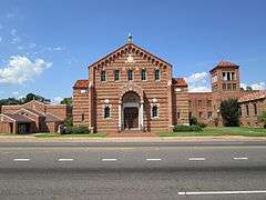
| 23 |
Holy Trinity Catholic Church |
|
000000001984-09-27-0000September 27, 1984
(#84001261) |
315 Marshall St.
32°30′51″N 93°45′03″W / 32.514167°N 93.750833°W / 32.514167; -93.750833 (Holy Trinity Catholic Church) |
Shreveport |
|
| 24 |
Walter B. Jacobs |
Upload image |
000000002016-09-19-0000September 19, 2016
(#16000670) |
5935 E. Ridge Dr.
32°27′09″N 93°44′07″W / 32.452417°N 93.735328°W / 32.452417; -93.735328 (Walter B. Jacobs) |
Shreveport |
|
| 25 |
Jefferson Hotel |
Upload image |
000000001989-07-27-0000July 27, 1989
(#89000977) |
907 Louisiana Ave.
32°30′29″N 93°44′53″W / 32.508056°N 93.748056°W / 32.508056; -93.748056 (Jefferson Hotel) |
Shreveport |
|
| 26 |
Kansas City Southern Depot |
|
000000001995-01-20-0000January 20, 1995
(#94001578) |
100 NW. Front St.
32°52′18″N 93°59′07″W / 32.871667°N 93.985278°W / 32.871667; -93.985278 (Kansas City Southern Depot) |
Vivian |
|
| 27 |
Kansas City Southern Railroad Bridge, Cross Bayou |
|
000000001995-03-23-0000March 23, 1995
(#95000347) |
Over Cross Bayou at Spring St.
32°31′10″N 93°45′01″W / 32.519444°N 93.750278°W / 32.519444; -93.750278 (Kansas City Southern Railroad Bridge, Cross Bayou) |
Shreveport |
|
| 28 |
Kings Highway Christian Church |
|
000000001989-08-07-0000August 7, 1989
(#89001042) |
806 Kings Highway
32°28′53″N 93°44′47″W / 32.481389°N 93.746389°W / 32.481389; -93.746389 (Kings Highway Christian Church) |
Shreveport |
|
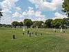
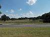
| 29 |
Lakeside Municipal Golf Course |
|
000000002005-06-01-0000June 1, 2005
(#05000504) |
2200 Milam
32°30′19″N 93°46′39″W / 32.505278°N 93.7775°W / 32.505278; -93.7775 (Lakeside Municipal Golf Course) |
Shreveport |
|
| 30 |
Lewis House |
|
000000001979-07-27-0000July 27, 1979
(#79001054) |
675 Jordan St.
32°29′52″N 93°44′39″W / 32.497778°N 93.744167°W / 32.497778; -93.744167 (Lewis House) |
Shreveport |
|
| 31 |
Col. Robert H. Lindsay House |
Upload image |
000000001973-07-16-0000July 16, 1973
(#73000861) |
2803 Woodlawn Ave.
32°28′58″N 93°43′46″W / 32.482778°N 93.729444°W / 32.482778; -93.729444 (Col. Robert H. Lindsay House) |
Shreveport |
|
| 32 |
Line Avenue School |
|
000000001981-06-03-0000June 3, 1981
(#81000289) |
1800 Line Ave.
32°29′39″N 93°44′48″W / 32.494167°N 93.746667°W / 32.494167; -93.746667 (Line Avenue School) |
Shreveport |
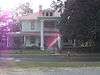
|
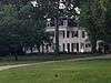
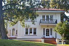
| 33 |
Huey P. Long House |
|
000000001991-08-15-0000August 15, 1991
(#91001060) |
305 Forest Ave.
32°28′47″N 93°44′10″W / 32.479722°N 93.736111°W / 32.479722; -93.736111 (Huey P. Long House) |
Shreveport |
|
| 34 |
Louisiana State Exhibit Building |
|
000000001991-02-20-0000February 20, 1991
(#91000071) |
3015 Greenwood Rd.
32°28′48″N 93°47′06″W / 32.48°N 93.785°W / 32.48; -93.785 (Louisiana State Exhibit Building) |
Shreveport |
|
| 35 |
Mason House |
Upload image |
000000002001-05-22-0000May 22, 2001
(#01000512) |
103 Ardmore
32°28′37″N 93°43′05″W / 32.476944°N 93.718056°W / 32.476944; -93.718056 (Mason House) |
Shreveport |
|
| 36 |
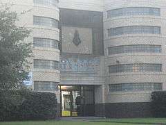
Masonic Temple |
|
000000001991-06-10-0000June 10, 1991
(#91000702) |
1805 Creswell St.
32°29′39″N 93°44′29″W / 32.494167°N 93.741389°W / 32.494167; -93.741389 (Masonic Temple) |
Shreveport |
|
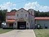
| 37 |
Mooringsport School |
Upload image |
000000001996-06-13-0000June 13, 1996
(#96000605) |
602 Latimer St.
32°41′14″N 93°57′38″W / 32.687222°N 93.960556°W / 32.687222; -93.960556 (Mooringsport School) |
Mooringsport |
|
| 38 |
Oakland Cemetery |
Upload image |
000000001977-07-13-0000July 13, 1977
(#77000667) |
Bounded by Milam, Christian, Sprague, and Baker Sts.
32°30′30″N 93°45′16″W / 32.508333°N 93.754444°W / 32.508333; -93.754444 (Oakland Cemetery) |
Shreveport |
|
| 39 |
Ogilvie Hardware Company Building |
Upload image |
000000002000-10-12-0000October 12, 2000
(#00001210) |
217 Jones St.
32°30′32″N 93°44′31″W / 32.508889°N 93.741944°W / 32.508889; -93.741944 (Ogilvie Hardware Company Building) |
Shreveport |
|
| 40 |
Old Commercial National Bank Building |
|
000000001982-03-11-0000March 11, 1982
(#82002759) |
509 Market St.
32°30′51″N 93°44′49″W / 32.514167°N 93.746944°W / 32.514167; -93.746944 (Old Commercial National Bank Building) |
Shreveport |
|
| 41 |
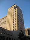
Petroleum Tower |
|
000000002013-09-17-0000September 17, 2013
(#13000730) |
425 Edwards St.
32°30′50″N 93°44′56″W / 32.513919°N 93.74886°W / 32.513919; -93.74886 (Petroleum Tower) |
Shreveport |
|
| 42 |
St. Mark's Episcopal Church |
|
000000001991-06-11-0000June 11, 1991
(#91000700) |
875 Cotton St.
32°30′24″N 93°45′04″W / 32.506667°N 93.751111°W / 32.506667; -93.751111 (St. Mark's Episcopal Church) |
Shreveport |
|
| 43 |
St. Paul's Bottoms |
Upload image |
000000001984-10-11-0000October 11, 1984
(#84000033) |
Roughly bounded by Western and Pierre Aves. and Alston, Christian, Oakland, and Snow Sts.; also 1002-1162 Texas Ave., 959-1057 Texas Ave., and 1127 Milam
32°30′31″N 93°45′26″W / 32.508611°N 93.757222°W / 32.508611; -93.757222 (St. Paul's Bottoms) |
Shreveport |
Second set of addresses represents a boundary increase of 000000001999-07-09-0000July 9, 1999
|
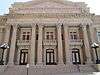
| 44 |
Scottish Rite Cathedral |
|
000000001986-11-06-0000November 6, 1986
(#86003132) |
725 Cotton St.
32°30′30″N 93°44′56″W / 32.508333°N 93.748889°W / 32.508333; -93.748889 (Scottish Rite Cathedral) |
Shreveport |
|
| 45 |
Shreveport Commercial Historic District |
Upload image |
000000001982-03-11-0000March 11, 1982
(#82002760) |
Roughly bounded by Commerce, Crockett, Common, and Travis Sts.; also roughly bounded by Commerce, Travis, Common, and Lake Sts.; also 710, 416, 410, 400, 330, 228, 220, 214, 208 Travis, 408, 223, 219, 217 Fannin, 305, 308, 401 Market Sts.
32°30′46″N 93°44′56″W / 32.512778°N 93.748889°W / 32.512778; -93.748889 (Shreveport Commercial Historic District) |
Shreveport |
Second and third sets of addresses represent boundary increases of 000000001997-05-16-0000May 16, 1997 and 000000002015-04-29-0000April 29, 2015
|
| 46 |
Shreveport Fire Station No. 8 |
|
000000002000-06-30-0000June 30, 2000
(#00000683) |
3406 Velva St.
32°28′49″N 93°46′53″W / 32.480278°N 93.781389°W / 32.480278; -93.781389 (Shreveport Fire Station No. 8) |
Shreveport |
|
| 47 |
Shreveport Municipal Building |
|
000000001982-05-05-0000May 5, 1982
(#82002761) |
724 McNeil St.
32°30′36″N 93°44′55″W / 32.51°N 93.748611°W / 32.51; -93.748611 (Shreveport Municipal Building) |
Shreveport |
|
| 48 |
Shreveport Municipal Memorial Auditorium |
|
000000001991-05-28-0000May 28, 1991
(#91000624) |
705 Grand Ave.
32°30′28″N 93°45′10″W / 32.507778°N 93.752778°W / 32.507778; -93.752778 (Shreveport Municipal Memorial Auditorium) |
Shreveport |
|
| 49 |
Shreveport Water Works Company, Pump Station |
|
000000001980-05-09-0000May 9, 1980
(#80001707) |
Off Louisiana Highway 3036
32°31′03″N 93°45′25″W / 32.5175°N 93.756944°W / 32.5175; -93.756944 (Shreveport Water Works Company, Pump Station) |
Shreveport |
|
| 50 |
Shreveport Woman's Department Club Building |
|
000000001985-07-18-0000July 18, 1985
(#85001590) |
802 Margaret Pl.
32°29′47″N 93°44′46″W / 32.496389°N 93.746111°W / 32.496389; -93.746111 (Shreveport Woman's Department Club Building) |
Shreveport |
|
| 51 |
South Highlands Fire Station |
|
000000001991-05-28-0000May 28, 1991
(#91000626) |
763 Oneonta
32°27′52″N 93°44′44″W / 32.464444°N 93.745556°W / 32.464444; -93.745556 (South Highlands Fire Station) |
Shreveport |
|
| 52 |
South Highlands Historic District |
Upload image |
000000001999-04-29-0000April 29, 1999
(#99000496) |
Roughly bounded by Richmond Ave., Trabue St., Line Ave., and Southfield Rd.
32°27′48″N 93°44′50″W / 32.463333°N 93.747222°W / 32.463333; -93.747222 (South Highlands Historic District) |
Shreveport |
|
| 53 |
Sprague Street Houses |
Upload image |
000000001983-10-03-0000October 3, 1983
(#83003606) |
1100-1118 Sprague St.
32°31′04″N 93°45′22″W / 32.517778°N 93.756111°W / 32.517778; -93.756111 (Sprague Street Houses) |
Shreveport |
|
| 54 |
Star Cemetery |
|
000000002002-01-17-0000January 17, 2002
(#01001478) |
Off the 2100 block of Texas Ave.
32°29′25″N 93°46′08″W / 32.490278°N 93.768889°W / 32.490278; -93.768889 (Star Cemetery) |
Shreveport |
|
| 55 |
A.C. Steere Elementary School |
Upload image |
000000001991-02-20-0000February 20, 1991
(#91000074) |
4009 Youree Dr.
32°28′00″N 93°43′17″W / 32.466667°N 93.721389°W / 32.466667; -93.721389 (A.C. Steere Elementary School) |
Shreveport |
|
| 56 |
Strand Theatre |
|
000000001977-05-26-0000May 26, 1977
(#77000668) |
630 Crockett
32°30′37″N 93°44′59″W / 32.510278°N 93.749722°W / 32.510278; -93.749722 (Strand Theatre) |
Shreveport |
|
| 57 |
Tally's Bank |
Upload image |
000000001976-07-14-0000July 14, 1976
(#76000963) |
525 Spring St.
32°30′51″N 93°44′47″W / 32.514167°N 93.746389°W / 32.514167; -93.746389 (Tally's Bank) |
Shreveport |
|
| 58 |
Taylor Wholesale Grocers and Cotton Factors Warehouse-Lee Hardware Building |
Upload image |
000000001986-02-13-0000February 13, 1986
(#86000251) |
719, 723, and 729 Edwards St.
32°30′43″N 93°44′47″W / 32.511944°N 93.746389°W / 32.511944; -93.746389 (Taylor Wholesale Grocers and Cotton Factors Warehouse-Lee Hardware Building) |
Shreveport |
|
| 59 |
Texas Avenue Buildings |
Upload image |
000000001979-05-25-0000May 25, 1979
(#79001055) |
824-864 Texas Ave.
32°30′30″N 93°45′08″W / 32.508333°N 93.752222°W / 32.508333; -93.752222 (Texas Avenue Buildings) |
Shreveport |
|
| 60 |
Thrasher House |
Upload image |
000000001987-09-10-0000September 10, 1987
(#87001565) |
8515 Youree Dr., Pioneer Heritage Center, Louisiana State University
32°25′54″N 93°42′07″W / 32.431667°N 93.701944°W / 32.431667; -93.701944 (Thrasher House) |
Shreveport |
|
| 61 |
Trees City Office and Bank Building |
|
000000001986-08-13-0000August 13, 1986
(#86001492) |
207 Land Ave.
32°44′28″N 93°58′13″W / 32.741111°N 93.970278°W / 32.741111; -93.970278 (Trees City Office and Bank Building) |
Oil City |
|
| 62 |
Trosper House |
|
000000001987-05-14-0000May 14, 1987
(#87000728) |
304 Magnolia St.
32°26′28″N 93°58′36″W / 32.441111°N 93.976667°W / 32.441111; -93.976667 (Trosper House) |
Greenwood |
|
| 63 |
U.S. Post Office and Courthouse |
|
000000001974-09-12-0000September 12, 1974
(#74000920) |
Marshall and Texas Sts.
32°30′43″N 93°44′59″W / 32.511944°N 93.749722°W / 32.511944; -93.749722 (U.S. Post Office and Courthouse) |
Shreveport |
|
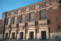
| 64 |
Booker T. Washington High School |
Upload image |
000000002015-07-14-0000July 14, 2015
(#15000414) |
2104 Milam St.
32°30′16″N 93°46′28″W / 32.5045°N 93.7744°W / 32.5045; -93.7744 (Booker T. Washington High School) |
Shreveport |
|
| 65 |
Samuel Wiener House |
|
000000002004-09-30-0000September 30, 2004
(#04001079) |
615 Longleaf Rd.
32°28′03″N 93°44′33″W / 32.4675°N 93.7425°W / 32.4675; -93.7425 (Samuel Wiener House) |
Shreveport |
|
| 66 |
Wile House |
|
000000001991-08-05-0000August 5, 1991
(#91001007) |
626 Wilder Pl.
32°28′34″N 93°44′34″W / 32.476111°N 93.742778°W / 32.476111; -93.742778 (Wile House) |
Shreveport |
|
| 67 |
Wray-Dickinson Building |
Upload image |
000000001983-03-24-0000March 24, 1983
(#83000492) |
308 Market St.
32°30′55″N 93°44′28″W / 32.515278°N 93.741111°W / 32.515278; -93.741111 (Wray-Dickinson Building) |
Shreveport |
|
| 68 |
YMCA, Downtown Branch |
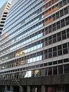
Upload image |
000000001991-05-28-0000May 28, 1991
(#91000621) |
400 McNeill St.
32°30′45″N 93°45′04″W / 32.5125°N 93.751111°W / 32.5125; -93.751111 (YMCA, Downtown Branch) |
Shreveport |
|


.jpg)