National Register of Historic Places listings in Barry County, Missouri
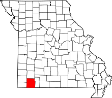
Location of Barry County in Missouri
This is a list of the National Register of Historic Places listings in Barry County, Missouri.
This is intended to be a complete list of the properties and districts on the National Register of Historic Places in Barry County, Missouri, United States. Latitude and longitude coordinates are provided for many National Register properties and districts; these locations may be seen together in a map.[1]
There are 15 properties and districts listed on the National Register in the county.
- This National Park Service list is complete through NPS recent listings posted December 16, 2016.[2]
Current listings
| [3] |
Name on the Register |
Image |
Date listed[4] |
Location |
City or town |
Description |
|---|
| 1 |
Camp Smokey/Company 1713 Historic District |
Upload image |
000000001985-02-26-0000February 26, 1985
(#85000513) |
Off Park Rd.
36°34′43″N 93°49′30″W / 36.578611°N 93.825°W / 36.578611; -93.825 (Camp Smokey/Company 1713 Historic District) |
Cassville |
|
| 2 |
Cassville Ranger Station Historic District |
Upload image |
000000002003-08-04-0000August 4, 2003
(#03000716) |
MO 248
36°40′23″N 93°51′32″W / 36.673056°N 93.858889°W / 36.673056; -93.858889 (Cassville Ranger Station Historic District) |
Cassville |
|
| 3 |
David W. Courdin House |
Upload image |
000000001971-11-05-0000November 5, 1971
(#71000460) |
2.4 miles SE of Monett
36°54′01″N 93°54′26″W / 36.900278°N 93.907222°W / 36.900278; -93.907222 (David W. Courdin House) |
Monett |
|
| 4 |
Downtown Monett Historic District |
Upload image |
000000002014-06-27-0000June 27, 2014
(#14000373) |
Parts of the 200-400 blks. of Broadway & Bond
36°55′16″N 93°55′28″W / 36.9210°N 93.9245°W / 36.9210; -93.9245 (Downtown Monett Historic District) |
Monett |
|
| 5 |
Natural Bridge Archeological Site |
Upload image |
000000001972-05-05-0000May 5, 1972
(#72000704) |
Address Restricted
|
Cassville |
|
| 6 |
Roaring River State Park Bath House |
Upload image |
000000001985-03-04-0000March 4, 1985
(#85000500) |
Off Park Rd.
36°34′46″N 93°49′49″W / 36.579444°N 93.830278°W / 36.579444; -93.830278 (Roaring River State Park Bath House) |
Cassville |
|
| 7 |
Roaring River State Park Dam/Spillway |
Upload image |
000000001985-02-28-0000February 28, 1985
(#85000518) |
Off Park Rd.
36°35′29″N 93°50′00″W / 36.591389°N 93.833333°W / 36.591389; -93.833333 (Roaring River State Park Dam/Spillway) |
Cassville |
|
| 8 |
Roaring River State Park Deer Leap Trail |
Upload image |
000000001985-02-26-0000February 26, 1985
(#85000519) |
Off Park Rd.
36°35′30″N 93°49′56″W / 36.591667°N 93.832222°W / 36.591667; -93.832222 (Roaring River State Park Deer Leap Trail) |
Cassville |
|
| 9 |
Roaring River State Park Honeymoon Cabin |
Upload image |
000000001985-02-26-0000February 26, 1985
(#85000520) |
Off Park Rd.
36°35′N 93°50′W / 36.58°N 93.83°W / 36.58; -93.83 (Roaring River State Park Honeymoon Cabin) |
Cassville |
|
| 10 |
Roaring River State Park Hotel |
Upload image |
000000001985-03-04-0000March 4, 1985
(#85000501) |
Off Park Rd.
36°35′25″N 93°50′02″W / 36.590278°N 93.833889°W / 36.590278; -93.833889 (Roaring River State Park Hotel) |
Cassville |
|
| 11 |
Roaring River State Park Shelter Kitchen No. 2 and Rest Room |
Upload image |
000000001985-02-26-0000February 26, 1985
(#85000521) |
Off Park Rd.
36°35′01″N 93°50′07″W / 36.583611°N 93.835278°W / 36.583611; -93.835278 (Roaring River State Park Shelter Kitchen No. 2 and Rest Room) |
Cassville |
|
| 12 |
Southwest Missouri Prehistoric Rock Shelter and Cave Sites Discontiguous Archeological District |
Upload image |
000000001991-10-24-0000October 24, 1991
(#91002046) |
1 mile (1.6 km) east of Mineral Spring at the source of Rockhouse Creek[5]
36°40′08″N 93°44′57″W / 36.668889°N 93.749167°W / 36.668889; -93.749167 (Southwest Missouri Prehistoric Rock Shelter and Cave Sites Discontiguous Archeological District) |
Cato |
Location is for Rockhouse Cave (23BY3), a part of the district
|
| 13 |
Tom Town Historic District |
Upload image |
000000001989-12-15-0000December 15, 1989
(#89002126) |
Off County Road VV, S of Pleasant Ridge
36°52′12″N 93°48′35″W / 36.87°N 93.809722°W / 36.87; -93.809722 (Tom Town Historic District) |
Pleasant Ridge |
|
| 14 |
Waldensian Church and Cemetery of Stone Prairie |
Upload image |
000000001985-01-18-0000January 18, 1985
(#85000100) |
Rt. 2
36°53′48″N 93°55′07″W / 36.896667°N 93.918611°W / 36.896667; -93.918611 (Waldensian Church and Cemetery of Stone Prairie) |
Monett |
|
| 15 |
Wheaton Missouri and North Arkansas Railroad Depot |
Upload image |
000000002000-02-10-0000February 10, 2000
(#00000085) |
Junction of Main and Barnett Sts.
36°45′48″N 94°03′15″W / 36.763333°N 94.054167°W / 36.763333; -94.054167 (Wheaton Missouri and North Arkansas Railroad Depot) |
Wheaton |
|
See also
References
- ↑ The latitude and longitude information provided in this table was derived originally from the National Register Information System, which has been found to be fairly accurate for about 99% of listings. For about 1% of NRIS original coordinates, experience has shown that one or both coordinates are typos or otherwise extremely far off; some corrections may have been made. A more subtle problem causes many locations to be off by up to 150 yards, depending on location in the country: most NRIS coordinates were derived from tracing out latitude and longitudes off of USGS topographical quadrant maps created under the North American Datum of 1927, which differs from the current, highly accurate WGS84 GPS system used by most on-line maps. Chicago is about right, but NRIS longitudes in Washington are higher by about 4.5 seconds, and are lower by about 2.0 seconds in Maine. Latitudes differ by about 1.0 second in Florida. Some locations in this table may have been corrected to current GPS standards.
- ↑ "National Register of Historic Places: Weekly List Actions". National Park Service, United States Department of the Interior. Retrieved on December 16, 2016.
- ↑ Numbers represent an ordering by significant words. Various colorings, defined here, differentiate National Historic Landmarks and historic districts from other NRHP buildings, structures, sites or objects.
- ↑ The eight-digit number below each date is the number assigned to each location in the National Register Information System database, which can be viewed by clicking the number.
- ↑ Adams, Lee. "Rockhouse Cave". Missouri Archaeologist 7.2 (1941): 18-27: 19.
|
|---|
|
| Topics | |
|---|
|
| Lists by states | |
|---|
|
| Lists by insular areas | |
|---|
|
| Lists by associated states | |
|---|
|
| Other areas | |
|---|
|
-
 Portal Portal
-
 WikiProject WikiProject
|
|
|---|
|
Lists
by county | | |
|---|
|
| Other lists | |
|---|
|
|