Nash Point
 Low Tower, Keepers cottages, Fog Horn house and Lighthouse at Nash Point | |
 Wales | |
| Location |
St Donats Vale of Glamorgan Wales United Kingdom |
|---|---|
| Coordinates | 51°24′03″N 3°33′08″W / 51.400863°N 3.552259°W |
| Year first constructed | 1832 |
| Automated | 1998 |
| Construction | stone tower |
| Tower shape | tapered cylindrical tower with balcony and lantern |
| Markings / pattern | white tower and lantern |
| Height | 37 metres (121 ft) |
| Focal height | 56 metres (184 ft) |
| Current lens | 360mm catadioptric |
| Intensity | 134,000 candela |
| Range | 21 nautical miles (39 km; 24 mi) |
| Characteristic | Fl (2) WR 15s. |
| Admiralty number | A5406 |
| NGA number | 5816 |
| ARLHS number | WAL-017 |
| Managing agent |
Trinity House[1] [2] |
Nash Point is a headland and beach in the Monknash Coast of the Vale of Glamorgan in south Wales, about a mile from Marcross.[3] It is a popular location for ramblers and hiking along the cliffs to Llantwit Major beach. The lighthouse meadow is a Site of Special Scientific Interest, containing rare plants such as the tuberous thistle, and other wildlife such as choughs can be seen.
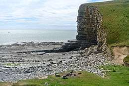

Parts of the section of the Glamorgan Heritage Coast where the lighthouse stands consists of "cliffs of Lias limestone interbedded with softer erodible material" and has been identified as potentially at risk from erosion and flooding.[4] Many fossils, including ammonites and gryphaea are to be found there. Marcross Brook passes through the cliffs and an Iron Age hillfort, usually called Nash Point Camp, stands on the north side of the brook, although its remains have been largely eroded by the sea.[5] Round barrows are also to be found nearby.[6] A study of the rocks shows that they exemplify "a 12,000 year old sequence of tufa, scree and slope deposits containing abundant fossil snails", while the Nash Bank offshore is formed by "Jurassic mudstones overlain by bands of sand and gravel".[7] In 1962, the empty tanker BP Driver (formerly the BP Explorer, which had been rebuilt following a disaster in the River Severn) was pushed on the rocks and was abandoned by its crew of five, all of whom survived. Despite the assistance given by the lighthouse, the ship's captain was unable to bring her in safely to land.[8] At low tide, remains of the wreck can be found about 200m north of the beach access by the light house.[9]
The Nash Point Lighthouse is a Grade II listed building, dating from 1831-32. There are two lights, a high light and a low light, located at a distance of around 300 metres from one another.[5] The leading light was removed during the 1920s because of the shifting location of the Nash sandbank.[10] The lighthouse was designed by James Walker, the chief engineer for Trinity House. Its construction is said to have been spurred by the wreck of The Frolic on the Nash Sands in March 1831,[10] which resulted in over 50 deaths, including that of Lt-Col N McLeod.[11] The ship was on its way from Bristol to Haverfordwest.[12] First lit in 1832, the lighthouse was electrified in 1968. Nash Point Lighthouse became the last manned lighthouse in Wales, and was automated in 1998. The lighthouse is now open to visitors, and is often used as a wedding venue; Trinity House provides public tours. The fog signal, no longer needed by ships, is sounded on the first Saturday and third Sunday of each month as an additional attraction to visitors.[13]
See also
References
- ↑ Nash Point The Lighthouse Directory. University of North Carolina at Chapel Hill. Retrieved 2 June 2016
- ↑ Nash Point Lighthouse Trinity House. Retrieved 2 June 2016
- ↑ "Weddings at Nash Point". Trinity House. Retrieved 1 May 2016.
- ↑ Swansea Bay Shoreline Management Plan. Swansea Bay Coastal Engineering Group. p. 238.
- 1 2 Griff Fellows (27 June 2014). The Coastal Headlands of Mainland Britain: A practical guide and much more.... eBookPartnership.com. pp. 137–. ISBN 978-1-78301-458-3.
- ↑ "Weddings at Nash Point". Coflein. RCAHMW. Retrieved 1 May 2016.
- ↑ Griff Fellows (27 June 2014). MCA 27 Glamorgan Coastal Waters & Nash Sands. Natural Resources Wales. p. 3.
- ↑ Chris Witts. "The BP EXPLORER capsized in the River Severn and killed the crew of five". Severntales.co.uk. Retrieved 23 January 2016.
- ↑ "Wreck on sands near Nash Point?". Ybw.com. Retrieved 23 January 2016.
- 1 2 "Welcome to Nash Point Lighthouse". Nash Point Lighthouse Visitor Centre. Retrieved 1 May 2016.
- ↑ John Wetherall (1832). An historical account of his majesty's First, or the royal regiment of foot. pp. 126–.
- ↑ "The Coast: Shipwrecks - Nash Point Lighthouses / Paddle Steamer Frolic". Kenfig: the Complete History. Retrieved 1 May 2016.
- ↑ "Nash Point Lighthouse". Visit the Vale. Vale of Glamorgan Council. Retrieved 1 May 2016.
External links
| Wikimedia Commons has media related to Nash Point. |
Coordinates: 51°24′14″N 3°33′41″W / 51.4038°N 3.5615°W