San Vicente, Northern Samar
| San Vicente | |
|---|---|
| Municipality | |
 | |
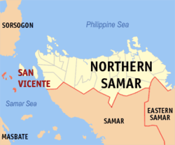 Map of Northern Samar with San Vicente highlighted | |
.svg.png) San Vicente Location within the Philippines | |
| Coordinates: 12°21′N 124°03′E / 12.35°N 124.05°ECoordinates: 12°21′N 124°03′E / 12.35°N 124.05°E | |
| Country | Philippines |
| Region | Eastern Visayas (Region VIII) |
| Province | Northern Samar |
| District | District of Northern Samar |
| Barangays | 7 |
| Government[1] | |
| • Mayor | Tito M. Luñeza |
| Area[2] | |
| • Total | 15.8 km2 (6.1 sq mi) |
| Population (2015 census) | |
| • Total | 7,856 |
| • Density | 500/km2 (1,300/sq mi) |
| Time zone | PST (UTC+8) |
| ZIP code | 6419 |
| Dialing code | +63 (0)55 |
| Income class | 6th |
| Website |
elgu |
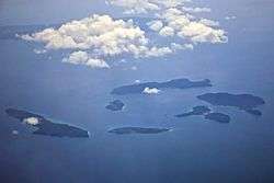
San Vicente is a sixth class municipality in the province of Northern Samar, Philippines. It is an island-municipality composed of seven islands of the Naranjo Island Group: Sila, Tarnate, Sangputan, Panganoron (Medio), Mahaba (Rasa), Maragat (San Andres) and Destacado[3] where the town proper is located. Destacado island is in the southernmost part of the group of islands comprising the municipality.
Locals speak Cebuano language and part Waray-Waray. According to the 2015 census, it has a population of 7,856 people.[2] It is the smallest municipality in the province, both in area and population.
The island municipality of San Vicente consists of six major islands; Destacado, Panganoron, Mahaba, Maragat, Sila, Tarnate, Sangputan. The islands of Panganoron, Mahaba, Maragat, Sila Tarnate and Sangputan form a circle of island group while Destacado lies in the far south of the group. The seat of government and town center is located in Destacado Island which separated several nautical miles from the rest of the group. Other smaller islands also form part of the municipality of San Vicente.
Barangays
San Vicente is politically subdivided into 7 barangays.[4]
- Destacado Poblacion (Barangay 2)
- Maragat (Maragat Island)
- Mongol Bongol Poblacio (Barangay 1)
- Punta Poblacion (Barangay 3)
- Sangputan
- Sila (Sila Island)
- Tarnate
Demographics
| Population census of San Vicente | ||
|---|---|---|
| Year | Pop. | ±% p.a. |
| 1990 | 5,777 | — |
| 1995 | 5,970 | +0.62% |
| 2000 | 5,831 | −0.50% |
| 2007 | 6,506 | +1.52% |
| 2010 | 7,447 | +5.04% |
| 2015 | 7,856 | +1.02% |
| Source: National Statistics Office[2][4] | ||
Economy
Since San Vicente is an island municipality, the primary source of income is fishing. Tourism is an untapped potential source of livelihood and jobs but it is undeveloped. The islands of Sila, Tarnate, Sangputan, Panganoron, Maragat, Mahaba boast of white sand beaches. At Sila island, a pink sand beach is tucked on its coast.
References
- ↑ "Municipalities". Quezon City, Philippines: Department of the Interior and Local Government. Retrieved 15 April 2013.
- 1 2 3 "Region VIII (EASTERN VISAYAS)". Census of Population (2015): Total Population by Province, City, Municipality and Barangay (Report). PSA. Retrieved 20 June 2016.
- ↑ http://beachanatic.blogspot.com/2006/11/san-vicente-northern-samar.html
- 1 2 "Province: Northern Samar". PSGC Interactive. Makati City, Philippines: National Statistical Coordination Board. Retrieved 15 April 2013.
External links
- ELGU Website of San Vicente Archived 25 April 2005 at the Wayback Machine.
- Philippine Standard Geographic Code
- Philippine Census Information
- Local Governance Performance Management System
 |
Matnog, Sorsogon Samar Sea |
Samar Sea / Capul | | |
| Batuan, Masbate / Samar Sea | |
|||
| ||||
| | ||||
| Dimasalang, Masbate / Samar Sea | |
Samar Sea / Tagapul-an, Samar |
Catarman (capital) | |
| Municipalities | |