Narail District
| Narail নড়াইল | |
|---|---|
 | |
| Coordinates: 23°08′N 89°30′E / 23.13°N 89.50°ECoordinates: 23°08′N 89°30′E / 23.13°N 89.50°E | |
| Seat | 93 (Narail-1), 94 (Narail-2) |
| Government | |
| • Narail Express | Mashrafe Bin Mortaza (Cricketer) |
| • BirShreshtha | Nur Mohammad |
| Area[1] | |
| • Total | 990.23 km2 (382.33 sq mi) |
| Population (2011 census)[1][2] | |
| • Total | 721,668 |
| Website |
www |
Narail (Bengali: নড়াইল Noraayil) is a district in south-western Bangladesh. It is a part of Khulna Division.[3]
History
Narail town was named after a feudal lord (a zamindar). The zamindars established a market at Roopgonj, also named after a zamindar. They established a post office for the first time in the district during British Raj near Rotongonj, named after another member of the feudal lord family. They modernised Narail, and promoted culture, sports and education.
The large playing field, Kuriddobe, was a gift of the feudal lord's family. They introduced football competition, with a shield given to the champions, a cup to the runners-up, and medals to all players from the early twentieth century.
One of the feudal lords moved away from Narail, settled in Hatbaria, and established another large manor (Jomidarbaari).
Geography
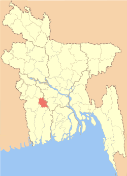
Narail District has an area of 990.23 square kilometres (382.33 sq mi). It is located to the south of Magura District, north of Khulna District, with the Faridpur District and Gopalganj District on the east, and Jessore District to the west.
Its average temperature ranges between 11.2C and 37.1C and has a yearly rainfall of 1467 mm.
Through the district flow the Madhumati, Nabaganga, Bhairab, and Chitra rivers. There are many beels and baors, the most noted of which is Chachuri Beel.
Land area:
- Cultivable area: 176,504-acre (714 km2)
- Fallow land: 25,090-acre (102 km2)
- Forest area: 10 acres
- Area irrigated: 36,208-acre (147 km2)
- River area: 8,562-acre (35 km2)
Religion
The district of Narail has 1675 mosques, 248 temples, four churches, seven tombs and 11 shrines.
The Radha Raman Smriti Tirtha Mandir, founded by Shri Tribhanga Brahmachary (Babaji of Shri Shri Bhagvat Sevashram Sangh) at Debbhog is a prominent place to visit, as are Nishinath Tola in Rupganj and Lakkhipasha Thakurbari.
Administration
Narail District was established in 1984. It is divided into three upazilas: Narail Sadar Upazila, Kalia Upazila and Lohagara Upazila. The upazilas are divided into Narail Sadar and Kalia municipalities, and 39 Union parishads. These are subdivided into 18 wards, 43 mahallas, 445 mouzas, and 651 villages.[3]
Points of interest
Narail Victoria College and Collegiate School is one of the oldest modern high schools in Bangladesh, established in 1858 by the landlords of Narail who were proponents of education. They also established a girls' school, a rarity in Bangladesh at that time. This was the Shib Shankar Memorial Girls' School. This school closed down due to lack of funding after they left East Pakistan for India. It was reopened by some local enthusiasts, like J. Bhattacharjee, S. Biswas and B. Bhowmic. They borrowed furnishings from the neighbours. They went house to houses soliciting parents to send their children to the school.
Narail Palace was one of the biggest landlord mansions in Bengal. When the Hindu landlords left East Pakistan for Kolkata after the partition of India, the mansion was looted and vandalised, and gradually collapsed. There are still some remains present, including the Kaalibaari (temple of goddess Kali), Shibmondir (temple of Lord Shiva) and the Bandha ghaat on the River Chitra. Some local people continued the famous Durga Puja in the mansion, but this was discontinued after a few years. Part of the building was used for some time as a government office. Due to lack of maintenance, it gave in.
Kalia Palace was another large landlord mansions in Bengal. Some landlords lived in Naragati. Naragati was a thana in the British period. The predecessor of Robi Sankar & Uday Sankar lived in Kalia.
The famous writer Bankim Chandra Chattopadhyay was a magistrate in Narail. His book Neelkuthi was based on the forceful cultivation of indigo in Narail by the East India Company.
Narail was once declared independent from the British Raj by Shorola di (Sister Shorola), as she was known at the time by her followers of the independence movement of India. But this "independence" lasted for only three days.
Transport
The town of Narail is the road transport hub of the district. To the west it is connected by regional highway R750 to Jessore, about 32 km away. R720 runs north 50 km to Magura. Within the district, Zilla road Z7503 runs east to Lohagara and on to the Kalna ferry ghat on the Madhumati River. Z7502 runs south, across the Nabaganga River at Baroipara Ghat by ferry, and on to Kalia.[4]
Notable residents
- Mashrafe Bin Mortoza, cricketer and captain of the Bangladesh national cricket team
- Suvra Mukherjee, First Lady of India, wife of President of India Pranab Mukherjee
- Bijoy Sarkar, poet, baul singer, lyricist, and composer
- SM Sultan, artist
See also
References
| Wikimedia Commons has media related to Narail District. |
- 1 2 3 "Population Census 2011: Narail Table C-01" (PDF). Bangladesh Bureau of Statistics. Retrieved July 11, 2014.
- 1 2 "Population Census 2011: Narail Table C-06" (PDF). Bangladesh Bureau of Statistics. Retrieved July 11, 2014.
- 1 2 3 Munshi, Md. Hamidul Haq (2012). "Narail District". In Islam, Sirajul; Jamal, Ahmed A. Banglapedia: National Encyclopedia of Bangladesh (Second ed.). Asiatic Society of Bangladesh.
- ↑ "RHD Road Network, Khulna Zone" (PDF). Roads and Highways Department. May 2005. Retrieved 25 July 2014.
External links
| Upazila/Thana: | ||
|---|---|---|
| Barisal Division |  | |
|---|---|---|
| Chittagong Division | ||
| Dhaka Division | ||
| Khulna Division | ||
| Mymensingh Division | ||
| Rajshahi Division | ||
| Rangpur Division | ||
| Sylhet Division | ||