Nan'yō
| Nan'yo 南陽市 | |||
|---|---|---|---|
| City | |||
|
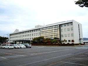
Nan'yo City Hall | |||
| |||
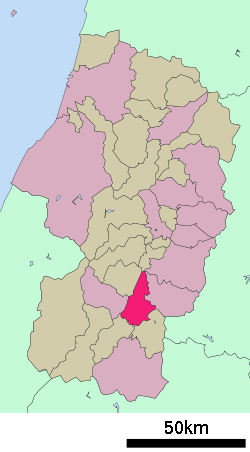 Location of Nan'yo in Yamagata Prefecture | |||
 Nan'yo
| |||
| Coordinates: 38°3′18.4″N 140°8′51.4″E / 38.055111°N 140.147611°ECoordinates: 38°3′18.4″N 140°8′51.4″E / 38.055111°N 140.147611°E | |||
| Country | Japan | ||
| Region | Tōhoku | ||
| Prefecture | Yamagata | ||
| Area | |||
| • Total | 160.52 km2 (61.98 sq mi) | ||
| Population (October 2015) | |||
| • Total | 31,976 | ||
| • Density | 199/km2 (520/sq mi) | ||
| Time zone | Japan Standard Time (UTC+9) | ||
| - Tree | Sakura | ||
| - Flower | Chrysanthemum | ||
| Phone number | 0238-40-3211 | ||
| Address | 436-1 Mitsumadori, Nanyō-shi, Yamagata-ken 999-2292 | ||
| Website | Official website | ||


Nanyo (南陽市 Nan'yō-shi) is a city located in Yamagata Prefecture, in the Tohoku region of northern Japan. As of October 2015, the city had an estimated population of 31,976 and a population density of 199 persons per km². The total area was 160.52 square kilometres (62 sq mi).
Geography
Nan'yo is located in southern Yamagata Prefecture, with mountains to the north, east and west and the Mogami River forming its southern border.
Neighboring municipalities
Climate
Nan'yo has a humid continental climate (Köppen climate classification Dfa) with large seasonal temperature differences, with warm to hot (and often humid) summers and cold (sometimes severely cold) winters. Precipitation is significant throughout the year, but is heaviest from August to October.
History
The area of present-day Nan'yo was part of ancient Dewa Province. After the start of the Meiji period, the area became part of Higashiokitama District, Yamagata Prefecture. The English travel-writer Isabella Bird visited Akayu in 1878 and wrote about the town in Unbeaten Tracks in Japan. The modern city of Nan'yo was established on April 1, 1967 by the merger of the former towns of Miyauchi and Akayu with the village of Wagō.
Akayu is famous for its hot springs, cherries and hang gliding and includes the former village of Nakagawa. Miyauchi is famous for its chrysanthemum festival and the Kumano-taisha Shrine, and includes the former villages of Urushiyama, Yoshino, and Kaneyama. The village of Wago was created in 1955 by the merger of the villages of Okigō and Ringō.
Economy
The economy of Nan'yo is based on agriculture, light manufacturing, and tourism.
Wine

Nanyo is home to the following three major wineries.
In addition to the three wineries, Nanyo is also home to a sake brewery called Azuma no Fumoto (東の麓).[4]
Education
High schools
- Nan'yō High School
Junior high schools
- Akayu Junior High School
- Miyauchi Junior High School
- Okigō Junior High School
Elementary schools
- Akayu Elementary School
- Kotaki Elementary School (Closed in 2012)
- Miyauchi Elementary School
- Nakagawa Elementary School
- Ogi Elementary School
- Okigō Elementary School
- Ringō Elementary School
- Urushiyama Elementary School
Transportation
Rail
Highways
Media
Newspapers
- Okitama Times[5]
Local attractions

- Inarimori Burial Mound, Akayu
- Akayu Onsen, Akayu
- Nan'yo Skypark, Akayu
- Mount Eboshi, Akayu. Listed as one of the 100 cherry blossoms sights in Japan.
- Toyotarō Yūki Memorial Museum, Akayu
- Kumano Shrine, Miyauchi
- Hygeia Park onsen complex, Miyauchi
- The 33 Images of Buddha, Mt Iwabu, Nakagawa
- Yuzuru no Sato Museum, Urushiyama
- Chinzo-ji Temple, Urushiyama
- Kuguri waterfall, Kotaki
- Lake Hakuryuu, Akayu
Local events
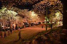
- Eboshiyama park cherry blossom festival, Akayu, late April to early May
- Sosho park rose festival, Miyauchi, June
- Kumano-taisha festival, Miyauchi, 24–25 July
- Grape picking, sightseeing vineyard, Akayu, August–October
- Nanyo wine festival, Hygeia park, Miyauchi, August
- Akayu onsen furosato festival, Akayu, second weekend of September
- Chrysanthemum doll festival, Miyauchi, mid-October to mid-November
Twin towns and sister cities
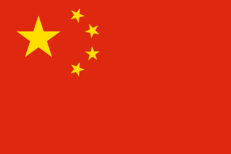 Nanyang, Henan, China,[6] since October 6, 1988
Notable people from Nan'yo
- Kyoko Inoue – professional wrestler
- Toyotarō Yūki – banker, politician
References
- ↑ "Sakai Winery".
- ↑ "Oura Winery".
- ↑ "Suto Winery".
- ↑ "Azuma Sake Brewery".
- ↑ Okitama Times
- ↑ "International Exchange". List of Affiliation Partners within Prefectures. Council of Local Authorities for International Relations (CLAIR). Retrieved 21 November 2015.
External links
| Wikimedia Commons has media related to Nanyō, Yamagata. |
- Official website (Japanese)
| Special city | ||
|---|---|---|
| Cities | ||
| Akumi District | ||
| Higashimurayama District | ||
| Higashiokitama District | ||
| Higashitagawa District | ||
| Kitamurayama District | ||
| Mogami District | ||
| Nishimurayama District | ||
| Nishiokitama District | ||