Naka-ku, Nagoya
| Naka 中区 | |
|---|---|
| Ward | |
| Naka Ward | |
|
| |
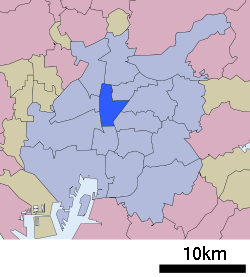 Location of Naka-ku in Nagoya | |
 Naka
| |
| Coordinates: 35°10′7″N 136°54′37″E / 35.16861°N 136.91028°ECoordinates: 35°10′7″N 136°54′37″E / 35.16861°N 136.91028°E | |
| Country | Japan |
| Region |
Tōkai region Chūbu region |
| Prefecture | Aichi |
| Area | |
| • Total | 9.38 km2 (3.62 sq mi) |
| Population (November 2011) | |
| • Total | 79,410 |
| • Density | 8,470/km2 (21,900/sq mi) |
| Time zone | Japan Standard Time (UTC+9) |
| - Tree | Ginkgo biloba [1] |
| - Flower | Pansy |
| Phone number | 052-241-3601 |
| Address | Sakae 4-chome, Naka-ku, Nagoya-shi, Aichi-ken 464-8644 |
| Website |
www |


Naka Ward (中区 Naka-ku) is one of the 16 wards of the city of Nagoya in Aichi Prefecture, Japan. As of 2011, the ward has an estimated population of 79,410 and a population density of 8,470 persons per km². The total area is 9.38 km².
Geography
Naka Ward is located in the center of Nagoya city. Largely hemmed in by Sakura-dōri (桜通り), Ōtsu-dōri (大津通り), Fushimi-dōri (伏見通り) and Tsurumai-dōri (鶴舞通り), it contains the main shopping area of Sakae, a massive air-conditioned 5 square-kilometer underground mall) and the 'after-five' semi-red light districts of Nishiki and Shin-sakae.
Surrounding municipalities
History
Naka Ward was one of the original four wards of the city of Nagoya, established on April 1, 1908. On February 1, 1944 a portion of Naka Ward was divided out to become Sakae Ward (栄区 Sakae-ku), but was merged back into Naka Ward on November 3, 1945. Most of the area was completed destroyed during the Bombing of Nagoya in World War II. After the war, the layout of the streets was changed to a grid pattern, with wide streets serving as firebreaks. The city is especially proud of Sakae's 100-meter road (100メートル道路) so named because of its width. There are small parks and areas for public performances in the area between two four-lane roads that service the city centre. The road is about 100 m (328 ft) in width, and 1 km (0.6 mi) in length.
Until the 1980s, town-planners were not allowed to build structures more than six stories in height outside of the business districts.
Economy
In addition the Sakae shopping area, there is also Ōsu, a sprawling old-style small-trader shopping area spreading out from the large Ōsu Kannon (大須観音), a Buddhist temple that holds flea markets. The covered streets house stalls selling fashion garments, TVs and alternative medicine give a taste of what Japan might have been like before modernization. Between Ōsu and Sakae can be found the city's Science and Modern Art museums. South of Ōsu is Kanayama Station (straddling the border with Atsuta-ku and Nakagawa-ku), Nagoya's second-most important rail transportation hub after Nagoya Station and a major access point for the Central Japan International Airport. Many izakayas and pachinko parlors can be found in its vicinity.
Naka-ku is also home to the city's Opera House and the main government offices, including the Nagoya City Hall and the Aichi Prefectural Government Office.
When Matsuzakaya was an independent company, its headquarters were in Naka-ku.[2]
Education
Transportation
Railroads
- JR Central - Chūō Main Line
- Meitetsu – Seto Line
- Nagoya Municipal Subway – Higashiyama Line
- Nagoya Municipal Subway – Sakura-dōri Line
- Nagoya Municipal Subway – Meijō Line
- Kanayama – Higashi Betsuin – Kamimaezu - Yabachō – Sakae – Hisaya-ōdōri – Shiyakusho
- Nagoya Municipal Subway – Tsurumai Line
- Marunouchi – Fushimi – Ōsu Kannon – Kamimaezu – Tsurumai
Highways
- Ring Route (Nagoya Expressway)
- Route 2 (Nagoya Expressway)
- Japan National Route 19
- Japan National Route 22
- Japan National Route 41
- Japan National Route 153
Notable local attractions
- Nagoya Castle
- Nagoya TV Tower
- Ōsu Kannon
- Banshō-ji
- Shōman-ji, Nagoya
- Nagoya City Science Museum
- Nagoya City Art Museum
- Electricity Museum, Nagoya
- Nagoya/Boston Museum of Fine Arts
- Hisaya Ōdori Park
- Misono-za
- Ran no Yakata
Noted people from Naka-ku, Nagoya
- Oda Nobunaga – samurai during the Sengoku period
- Midori Ito – professional figure skater
- Hiroshi Tachi –actor, singer
References
- ↑ 区章 区の花 区の木 (in Japanese). Nagoya City. 21 January 2009. Retrieved 7 January 2011.
- ↑ "役員・会社概要." Matsuzakaya. May 17, 2001. Retrieved on December 15, 2010. "本社 名古屋市中区栄三丁目16番1号."
External links
| Wikimedia Commons has media related to Naka-ku, Nagoya. |
| Wards of Nagoya | ||
|---|---|---|
| Core cities | ||
| Special cities | ||
| Cities | ||
| Aichi District | ||
| Ama District | ||
| Chita District | ||
| Kitashitara District | ||
| Nishikasugai District | ||
| Niwa District | ||
| Nukata District | ||