Nacoochee Mound
Coordinates: 34°41′0.07″N 83°42′32.27″W / 34.6833528°N 83.7089639°W
|
The Nacoochee Mound | |
 Location within modern Georgia | |
| Location |
Helen, Georgia, White County, Georgia, |
|---|---|
| Region | White County, Georgia |
| Coordinates | 34°41′.07″N 83°42′32.27″W / 34.6833528°N 83.7089639°W |
| History | |
| Founded | 100 BCE |
| Abandoned | 1600 CE |
| Periods | Early Middle Woodland, Lamar Phase |
| Cultures | South Appalachian Mississippian culture |
| Site notes | |
| Excavation dates | 1915, 2004 |
| Archaeologists | Frederick Webb Hodge, George H. Pepper |
| Architecture | |
| Architectural styles | platform mound |
| Architectural details |
Number of temples: 1 |
|
Sautee Valley Historic District | |
| NRHP Reference # | 86002742 |
| Added to NRHP | August 20, 1986[1] |
The Nacoochee Mound (Smithsonian trinomial 9WH3) is an archaeological site on the banks of the Chattahoochee River in White County, in the northeast part of the U.S. state of Georgia, at the junction of Georgia Georgia State Route 17 and Georgia State Route 75. First occupied as early as 100-500 CE, the site was later developed and occupied more intensively by peoples of the South Appalachian Mississippian culture (a regional variation of the Mississippian culture) from 1350 to 1600 CE.[2] One of their characteristic platform mounds is located at the site. A professional archeological excavation revealed a total of 75 human burials, with artifacts that support dating of the site.
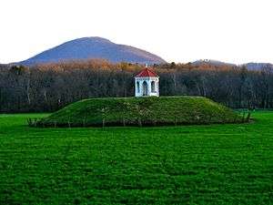
The mound was excavated, but a reconstruction was built. The 19th-century gazebo was added by a European-American owner of the land.[3]
Unlike other Mississippian sites, this does not appear to have been occupied by the later Cherokee peoples. The site is part of the Sautee Valley Historic District; it was added to the National Register of Historical Places on August 20, 1986 as reference number 86002742.[1]
Site description

In the 1870s, the mound site was owned by Captain John H. Nichols, who reported plowing up Mississippian culture stone box graves to the west of the mound. The mound in 1873 was described as being 16 feet (4.9 m) in height, in a report on Native American sites in Georgia, written by Charles C. Jones. In 1890 Captain Nichols removed the top 2 feet (0.61 m) of the mound and built a locally famous gazebo on its new summit.
The mound was formally excavated in 1915 by a team of archaeologists headed by Frederick Webb Hodge and George H. Pepper and sponsored by the Heye Foundation and the Bureau of American Ethnology (now part of the Smithsonian Institution).[4] George Gustav Heye wrote a book with Hodge and Pepper about the excavation, The Nacoochee Mound in Georgia (1918).[5] The excavation uncovered 75 human burials, including 56 adults, seven adolescents, and four children, and eight bodies that were too degraded for their ages to be determined.[4]
The burials were layered, dating from different time periods. About a third of the individuals were buried with artifacts indicative of social status, including hammered copper and stone celts, conch shell beads and cups, and elaborate Mississippian culture pottery. Some later burials included glass beads and sheet brass ornaments, indicating that these were intrusive burials of 17th-century Europeans.[3]

Test excavations at the site in 2004 by the University of Georgia Archaeology Field School resulted in evidence that the sites was occupied during the Early Middle Woodland Cartersville Phase. It was most intensively occupied during the Mississippian period, from 1350 to 1600 CE during the Lamar Phase. Pottery sherds characteristic of the Etowah Indian Mounds site in Cartersville, Georgia were found at the site and are evidence that the two sites were occupied during the same time period. A small village area was located in the field to the east of the mound and a much larger village area in the field to the west of the mound. [4]
Archaeological evidence suggests that Nacoochee Mound site, and a nearby mound site called the Eastwood Site (9Wh2), served as local administrative centers in the late 15th century and early 16th centuries. A bronze historical marker at the site claims it is the "ancient Cherokee town of Gauxule, visited by Hernando de Soto in 1540." Little to no evidence of Cherokee occupation was found during the 2004 test excavations, and it is doubtful that they ever inhabited the site.[3][4]
The original Nacoochee Mound was partially excavated. A reconstruction of this mound was built and survives on the estate of former Georgia governor Lamartine Griffin Hardman, in the Nacoochee Valley in White County, two miles south of Helen.
See also
References
- 1 2 "National Register of Historic Places". Retrieved 2012-04-09.
- ↑ "Southeastern Prehistory:Mississippian and Late Prehistoric Period". National Park Service. Retrieved 2012-04-10.
- 1 2 3 Langford, James B., Jr. (2002-08-08). "Nacoochee Mound". The New Georgia Encyclopedia. The Georgia Humanities Council and the University of Georgia Press. Retrieved 2012-04-10.
- 1 2 3 4 Mark Williams (2004). "Nacoochee Revisited: The 2004 Project" (PDF). University of Georgia, Lamar Institute.
- ↑ "The Nacoochee Mound in Georgia (1918)". American Libraries. Internet Archive. Retrieved 2007-05-27.
External links
- Folk Pottery Museum of Northeast Georgia
- Nacoochee Mound images, National Museum of the America Indian

| Archaeological cultures |
|
|---|---|
| Archaeological sites |
|
| Human remains | |
| Miscellaneous |
|
| |