Nørvøya
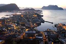 Ålesund as seen from Aksla | |
 Nørvøya Location in Møre og Romsdal | |
| Geography | |
|---|---|
| Location | Sunnmøre, Norway |
| Coordinates | 62°28′31″N 06°11′43″E / 62.47528°N 6.19528°ECoordinates: 62°28′31″N 06°11′43″E / 62.47528°N 6.19528°E |
| Area | 5 km2 (1.9 sq mi) |
| Length | 5.7 km (3.54 mi) |
| Width | 1.2 km (0.75 mi) |
| Highest elevation | 135 m (443 ft) |
| Highest point | Aksla |
| Administration | |
| County | Møre og Romsdal |
| Municipality | Ålesund Municipality |
| Demographics | |
| Population | 8,665 (2001) |
Nørvøya (or Nørve) is an island in Ålesund Municipality in Møre og Romsdal county, Norway. It is the largest of the islands containing the city center of Ålesund, the others being Aspøya and Heissa, located to the west. The 5-square-kilometre (1.9 sq mi) island of Nørvøya is located south of Ellingsøya, north of Sula, and west of Oksenøya.
Ålesund University College, the city hall, Volsdalen Church, and the stadium of the local association football team Aalesunds FK are located on Nørvøya. The 135-metre (443 ft) hill Aksla, a popular place from where to photograph the city, is located on the western part of Nørvøya. The European route E136 highway runs along the south side of the island, connecting it to the other islands of Oksenøya (on the east) and Aspøya (on the west). On Nørvøya, the E136 highway connects to the Ellingsøy Tunnel, which is an undersea tunnel that connects to the village of Hoffland on Ellingsøya to the north.[1]
References
- ↑ Store norske leksikon. "Nørvøya" (in Norwegian). Retrieved 2010-10-02.