Námestovo
| Námestovo | ||
| Town | ||
 Hviezdoslav Square in Námestovo | ||
|
||
| Country | Slovakia | |
|---|---|---|
| Region | Žilina | |
| District | Námestovo | |
| Tourism region | Orava | |
| Elevation | 614 m (2,014 ft) | |
| Coordinates | SK 49°24′10″N 19°28′53″E / 49.40278°N 19.48139°ECoordinates: SK 49°24′10″N 19°28′53″E / 49.40278°N 19.48139°E | |
| Area | 44.474 km2 (17 sq mi) | |
| Population | 8,094 (2005-12-31) | |
| Density | 182/km2 (471/sq mi) | |
| First mentioned | 1557 | |
| Mayor | Ján Kadera | |
| Timezone | CET (UTC+1) | |
| - summer (DST) | CEST (UTC+2) | |
| Postal code | 029 01 | |
| Phone prefix | 421-43 | |
| Car plate | NO | |
  Location of Námestovo in Slovakia | ||
  Location of Námestovo in the Žilina Region | ||
| Wikimedia Commons: Námestovo | ||
| Statistics: MOŠ/MIS | ||
| Website: www.namestovo.sk | ||

Námestovo (Hungarian: Námesztó; Polish: Namiestowo) is a town in northern Slovakia. It is the capital and largest town of Námestovo District in the Žilina Region. As of 2005 its population was 8,094.
Etymology
The name is derived from a word námesta (a representative, a deputy; like modern Slovak námestník or Czech náměstek) referring to a representative of Vlach settlers whose seat was in Námestovo.[1] Alternatively, it could be derived from a personal name Namest (a less probable theory).[1]
Geography
The town is located under the Orava Highlands at the shores of the Orava reservoir, not far from the Polish border, around 15 km (9.32 mi) from Tvrdošín and 30 km (18.64 mi) from Dolný Kubín.
History
The town was mentioned in the 16th century, when the massive colonisation of Orava took place. It was growing quickly, thanks to its favourable location on the trade route to Poland. The town was burned down at the end of the World War II. The construction of the Orava reservoir affected the way of life in the town, as two-thirds of the town were inundated, including the town centre. Boom of the industry and the following apartment construction in the 1970s contributed to the growth of the town.
Meteorite Magura Meteorite Magura
Demographics
According to the 2001 census, the town had 8,135 inhabitants. 98.65% of inhabitants were Slovaks and 0.65% Czechs.[2] The religious makeup was 92.12% Roman Catholics, 4.95% people with no religious affiliation and 0.84% Lutherans.[2]
Pictures
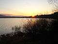 Sunset above Orava dam lake
 Námestovo in winter
 Námestovo in autumn
People
References
- 1 2 Krajčovič, Rudolf (2013). "Z lexiky stredovekej slovenčiny s výkladmi názvov obcí a miest (38)". Kultúra slova (in Slovak). Martin: Vydavateľstvo Matice slovenskej (3): 92.
- 1 2 "Municipal Statistics". Statistical Office of the Slovak republic. Archived from the original on 2008-01-11. Retrieved 2008-01-26.
External links
- The Town of Námestovo (Slovak)
Municipalities of Námestovo District | ||
|---|---|---|