Mzingwane River
| Mzingwane River | |
| River | |
 | |
| Country | Zimbabwe |
|---|---|
| Source | |
| - location | South of Bulawayo, Zimbabwe |
| Mouth | |
| - location | Limpopo River, South Africa–Zimbabwe border |
| - elevation | 452 m (1,483 ft) |
| - coordinates | 22°11′13″S 29°55′32″E / 22.18694°S 29.92556°ECoordinates: 22°11′13″S 29°55′32″E / 22.18694°S 29.92556°E |
| Basin | 15,695 km2 (6,060 sq mi) |
| Discharge | |
| - average | 22.30 m3/s (788 cu ft/s) |
| [1] | |

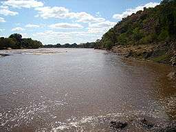
The Mzingwane River, formerly known Umzingwane River as or Umzingwani River is a major left-bank tributary of the Limpopo River in Zimbabwe. It rises near Fort Usher, Matobo District, south of Bulawayo and flows into the Limpopo River near Beitbridge, downstream of the mouth of the Shashe River and upstream of the mouth of the Bubye River.
Hydrology
The Mzingwane River is an ephemeral river with flow generally restricted to the months when rain takes place (November to March), with most flow recorded between December and February, except where it has been modified by dam operations.[2] The river contributes 9.3% of the mean annual runoff of the Limpopo Basin, making it the third largest tributary to the Limpopo basin.[1]
Major tributaries of the Mzingwane River include the Insiza, Inyankuni, Ncema, Umchabezi (not to be confused with Mtshabezi) and Mtetengwe Rivers.
The lower Mzingwane River is a sand filled channel, with extensive alluvial aquifers in the river channel and below the alluvial plains. Estimated water resources potential of these aquifers ranges between 175,000 m3 and 5,430,0003 in the channels and between 80,000 m3 and 6,920,0003 in the plains. Currently, some of these aquifers are being used to provide water for domestic use, livestock watering and dip tanks, commercial irrigation and market gardening.[3]
Settlements along the river
The settlements below are ordered from the beginning of the river to its end:
- Mbalabala village
- Gwanda town
- West Nicholson village
- Beitbridge town is located about 6 km ESE of the confluence of the Bubye River and the Limpopo on the border with South Africa. It was established in 1929.[4]
Bridges and crossings

There are four main bridges over the Mzingwane River:
- Bridge on main Bulawayo - Beitbridge road, between Esigodini and Mbalabala, downstream of Mzingwane Dam. There is also a rail bridge.
- Bridge on main Mbalabala - Masvingo road.
- Bridge on main Bulawayo - Beitbridge road at West Nicholson, downstream of confluence with Insiza River. There is also a rail bridge.
- Bertie Knott Bridge, on the road from Beitbridge to Shashe Irrigation Scheme, near the mouth.
There are also a number of fords, including:
- Two fords upstream of West Nicholson on Silalabuhwa and Mosholomoshe roads.
- Doddieburn ford, downstream of West Nicholson.
- Gems Drift, near Beitbridge.
- Fulton's Drift, near Beitbridge.
Development

In addition to a number of small weirs, there are two major dams on the Mzingwane River:
- Mzingwane Dam, built in 1962, with a full supply capacity of 42 MCM (million cubic metres). It is located near the source of the river and supplies water to the city of Bulawayo.
- Zhovhe Dam, built in 1995, with a full supply capacity of 136 MCM. It is located near the confluence with the Limpopo River and supplies water for irrigation to Beitbridge
Additional dam sites have been identified at Glassblock and Oakley Block, but development is not currently scheduled.[5]
Currently, a project is underway to construct a pipeline from the upper Mtshabezi River (not to be confused with Umchabezi River) to Mzingwane Dam.
References
| Wikimedia Commons has media related to Mzingwane River. |
- 1 2 Görgens, A.H.M.; Boroto, R.A. (1997). Limpopo River: flow balance anomalies, surprises and implications for integrated water resources management. Proceedings of the 8th South African National Hydrology Symposium. Pretoria.
- ↑ Love, D., Uhlenbrook, S., Nyabeze, W., Owen, R.J.S., Twomlow, S., Savenije, H. , Woltering, L. and van der Zaag, P. 2005. Modelling of hydrological change for IWRM planning: case study of the Mzingwane River, Limpopo Basin, Zimbabwe. In: Abstract Volume, 6th WaterNet/WARFSA/GWP-SA Symposium, Ezulwini, Swaziland, November 2005, p31.
- ↑ Moyce, W., Mangeya, P., Owen, R. and Love, D. 2006. Alluvial aquifers in the Mzingwane Catchment: their distribution, properties, current usage and potential expansion. Physics and Chemistry of the Earth, 31, 988-994.
- ↑ Beitbridge
- ↑ Chibi, T., Kandori, C. and Makone, B.F. (2005). Mzingwane Catchment Outline Plan. Bulawayo: Zimbabwe National Water Authority.