Umzimkulu River
| Umzimkulu River | |
| uMzimkhulu, Mzimkulu | |
| River | |
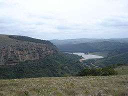 Umzimkulu river scene | |
| Name origin: Meaning 'big place', 'large home', ie of the waters, in the Xhosa language[1] | |
| Country | South Africa |
|---|---|
| Region | KwaZulu-Natal |
| Source | _ |
| - location | Drakensberg |
| Source confluence | Ngwangwane / Underberg |
| - elevation | 943 m (3,094 ft) |
| - coordinates | ZA 30°03′24″S 29°47′26″E / 30.05667°S 29.79056°E |
| Mouth | Indian Ocean |
| - location | Port Shepstone |
| - elevation | 0 m (0 ft) |
| - coordinates | ZA 30°44′12″S 30°27′25″E / 30.73667°S 30.45694°ECoordinates: ZA 30°44′12″S 30°27′25″E / 30.73667°S 30.45694°E |
 Location of the Umzimkulu River mouth | |
The Umzimkulu River is a river in South Africa.[2] It rises in the Drakensberg mountains at the confluence of the Ngwangwane and the Underberg River. It flows southeast towards the Indian Ocean, which it enters through an estuary at Port Shepstone.
Towns on the Umzimkulu include Underberg and Umzimkulu. Its main tributary is the Bisi River which joins its right bank about halfway down its course.[3] In the past, the Umzimkulu formed part of the border between Eastern Cape and Kwazulu-Natal.
Presently this river is part of the Mvoti to Umzimkulu Water Management Area.[4]
In late February of every year, the river is host to one of South Africa's most popular canoe races, the Drak Challenge.[5]
Ecology
The Scaly Yellowfish (Labeobarbus natalensis) is a fish found in the Umzimkulu River System as well as in the Umgeni, Umkomazi, Tukhela and the Umfolozi. It is a common endemic species in KwaZulu-Natal Province and it lives in different habitats between the Drakensberg foothills and the coastal lowlands.[6]

See also
References
- ↑ Dictionary of Southern African Place Names
- ↑ Meintjes, Malcolm (2005). Remarkable Flyfishing Destinations of Southern Africa. Struik. ISBN 1-86872-976-1.
- ↑ Mvoti to Umzimkulu WMA 11
- ↑ Is there a role for traditional governance systems in South Africa's new water management regime?
- ↑ Drak Challenge
- ↑ Technical Report on the State of Yellowfishes in South Africa 2007