Myślenice
| Myślenice | |||
|---|---|---|---|
|
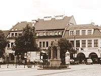
Market Square | |||
| |||
 Myślenice | |||
| Coordinates: 49°50′N 19°56′E / 49.833°N 19.933°E | |||
| Country |
| ||
| Voivodeship | Lesser Poland | ||
| County | Myślenice County | ||
| Gmina | Gmina Myślenice | ||
| Government | |||
| • Mayor | Maciej Ostrowski | ||
| Area | |||
| • Total | 30.1 km2 (11.6 sq mi) | ||
| Population (2007) | |||
| • Total | 20,261 | ||
| • Density | 670/km2 (1,700/sq mi) | ||
| Time zone | CET (UTC+1) | ||
| • Summer (DST) | CEST (UTC+2) | ||
| Postal code | 32-400 | ||
| Car plates | KMY | ||
| Website | http://www.myslenice.pl | ||


Myślenice [mɨɕlɛˈɲit͡sɛ] is a town in southern Poland, situated in the Lesser Poland Voivodeship (since 1999), previously in Kraków Voivodeship (1975–1998). Population: 20,261(2007). The town is divided into six districts. One of them, Zarabie, is a popular tourist destination. It is located behind the Raba river (hence the name), and it has Chełm mountain, with a view tower, a landscape park and ski lifts.
Myślenice is located on the so-called Zakopianka Road, which is a popular name of the European route E77 road, connecting Kraków with Zakopane (the E77 itself separates itself from the Zakopianka at Rabka). Myślenice does not have a train station.
First mentions of Myślenice come from 1253 - 1258. At that time, it was a defensive settlement, with a castle and fortifications, designed to protect Kraków from the south. In 1342, Myślenice received its Magdeburg rights town charter, and it started to develop into a local commercial center. Among visitors who came here, were Mikolaj Rej, King Władysław II Jagiełło, German emperor Sigismund, and other personalities. In 1557, Myślenice came under the jurisdiction of Kraków castellans, who were much more concerned with their city. The town began to decline, and it was destroyed in the deluge. In 1772 (see Partitions of Poland), Myślenice was annexed by Austria, and until 1918, it belonged to the province of Galicia. After World War I, the town became part of the Second Polish Republic.
International relations
Twin towns — Sister cities
Sports
- Dalin Myślenice - women's volleyball team that has won Polish Seria B Women's Volleyball League in 2003/2004 season and was promoted to play in Polish Seria A Women's Volleyball League in 2004/2005 season.
- CFL slotback Dave Stala was born here.
External links
- Jewish Community in Myślenice on Virtual Shtetl
References
- 1 2 3 4 5 6 "Myślenice - Miasta partnerskie" [Myślenice - Partnership Cities] (in Polish). Archived from the original on 2013-05-02. Retrieved 2013-08-04.
- ↑ "Portal Bełchatów" [Bełchatów - Partnership Cities]. Miasto Bełchatów [Bełchatów town council] belchatow.pl (in Polish). 2010. Archived from the original on 13 June 2011. Retrieved 22 June 2011.
| Wikimedia Commons has media related to Myślenice. |
Seat: Myślenice | ||
| Urban-rural gminas |  | |
| Rural gminas | ||
| Town and seat |  | |
|---|---|---|
| Villages | ||
Coordinates: 49°50′N 19°56′E / 49.833°N 19.933°E