Mustang District
| Mustang मुस्ताङ जिल्ला སྨོནཋང | |
|---|---|
| District | |
 Location of Mustang | |
| Country | Nepal |
| Region | Western (Pashchimanchal) |
| Zone | Dhaulagiri |
| Area | |
| • Total | 3,573 km2 (1,380 sq mi) |
| Population (2011) | |
| • Total | 13,452 |
| • Density | 3.8/km2 (9.8/sq mi) |
| Time zone | NPT (UTC+5:45) |


Mustang District (Nepali: मुस्ताङ जिल्ला![]() Listen ), a part of Province No. 4, is one of the seventy-five districts of [Nepal]. The district, with Jomsom as its headquarters, covers an area of 3,573 km² and has a population (2011) of 13,452.[1]
Listen ), a part of Province No. 4, is one of the seventy-five districts of [Nepal]. The district, with Jomsom as its headquarters, covers an area of 3,573 km² and has a population (2011) of 13,452.[1]
The district straddles the Himalayas and extends northward onto the Tibetan plateau. Upper Mustang, the former Lo Kingdom comprises the northern two-thirds of the district. This kingdom was a dependency of the Kingdom of Nepal but was abolished by the republican Government of Nepal on October 7, 2008.
In addition to trekking routes through the Lo Kingdom ("Upper Mustang") and along the Annapurna Circuit in lower Mustang, the district is famous for the springs and village of Muktinath (a popular Hindu and Buddhist pilgrimage site), apples, and Marpha brandy. Mustang was a lost kingdom of Tibet where traditions may remain more Tibetan than in Tibet proper following its annexation by China.

Geography and Climate
| Climate Zone[2] | Elevation Range | % of Area |
|---|---|---|
| Temperate | 2,000 to 3,000 meters 6,400 to 9,800 ft. |
4.0% |
| Subalpine | 3,000 to 4,000 meters 9,800 to 13,100 ft. |
4.7% |
| Alpine | 4,000 to 5,000 meters 13,100 to 16,400 ft. |
2.7% |
| Nival | above 5,000 meters | 8.8% |
| Trans-Himalayan[3] | 3,000 to 6,400 meters 9,800 to 21,000 ft. |
79.8% |
Village Development Committees (VDCs)
- Charang
- Chhonhup
- Chhoser
- Chhusang
- Dhami
- Jhong
- Jomsom
- Kagbeni
- Kowang
- Kunjo
- Lete
- Lo Manthang
- Marpha
- Muktinath
- Surkhang
- Tukuche
 Mustang has a semi-arid climate |
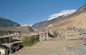
 A village in Mustang District |
 The only airport in Mustang |
See also
- Gandaki River
- Jomsom
- Jomsom Airport
- Kagbeni, Mustang
- Kali Gandaki Gorge
- Kali Gandaki River
- Lo Manthang
- Mustang (kingdom)
- Tangbe
- Upper Mustang
- Zones of Nepal
References
- ↑ "National Population and Housing Census 2011 (National Report)" (PDF). Central Bureau of Statistics. Retrieved November 2012. Check date values in:
|access-date=(help) - ↑ The Map of Potential Vegetation of Nepal - a forestry/agroecological/biodiversity classification system (PDF), . Forest & Landscape Development and Environment Series 2-2005 and CFC-TIS Document Series No.110., 2005, ISBN 87-7903-210-9, retrieved Nov 22, 2013 horizontal tab character in
|series=at position 91 (help) - ↑ Shrestha, Mani R.; Rokaya, Maan B.; Ghimire, Suresh K. (2005). "Vegetation pattern of Trans-Himalayan zone in the North-West Nepal". Nepal Journal of Plant Sciences. 1: 129–135. Retrieved Feb 7, 2014.
- ↑ Banerji, Gargi; Basu, Sejuti. "Climate Change and Himalayan Cold Deserts: Mapping vulnerability and threat to ecology and indigenous livelihoods" (PDF). Pragya. Gurgaon, Haryana, India. Retrieved February 7, 2014.
External links
- "Districts of Nepal". Statoids.
Headquarter: Jomsom | |||
 | | ||
Coordinates: 28°47′0″N 83°43′50″E / 28.78333°N 83.73056°E
| Wikimedia Commons has media related to Mustang District. |