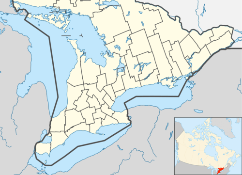
Muskoka Lakes
| Muskoka Lakes | |
|---|---|
| Township (lower-tier) | |
| Township of Muskoka Lakes | |
|
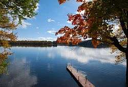
A typical lake scene in Muskoka Lakes. | |
 Muskoka Lakes | |
| Coordinates: 45°07′N 79°35′W / 45.117°N 79.583°WCoordinates: 45°07′N 79°35′W / 45.117°N 79.583°W | |
| Country |
|
| Province |
|
| Regional Municipality | Muskoka |
| Established | 1971 |
| Government | |
| • Type | Township |
| • Mayor | Don Furniss |
| • Governing Body | Muskoka Lakes Township Council |
| • MP | Tony Clement (CPC) |
| • MPP | Norm Miller (OPC) |
| Area[1] | |
| • Land | 794.48 km2 (306.75 sq mi) |
| Population (2011)[2] | |
| • Total | 6,707 |
| • Density | 8.4/km2 (22/sq mi) |
| Time zone | EST (UTC-5) |
| • Summer (DST) | EDT (UTC-4) |
| Postal code FSA | P0B |
| Area code(s) | 705 |
| Website | www.muskokalakes.ca |
The Township of Muskoka Lakes is an area municipality of the District Municipality of Muskoka, Ontario, Canada. It has a year-round population of 6,707.[2]
History and government
The area now covered by the township was opened for settlement and organized in 1870 into the following geographic (and sometime municipal) townships of Watt, Cardwell, Humphrey, Christie, Medora and Wood.
In 1971, the current municipal structure took hold when Cardwell Township, Watt Township, Medora and Wood Townships, Bala, Port Carling, Windermere and part of Monck Township were merged.
The municipal offices are located in Port Carling.
Communities

The township contains the communities of Bala, Bala Park, Bardsville, Barlochan, Beaumaris, Baysville, Bear Cave, Beatrice, Bent River, Brackenrig, Cedar Village, Dee Bank, Dixon's Corners, Dudley, Duffy, Echo Beach, Ferndale, Foot's Bay, Glen Orchard, Gregory, Gull Rock, Hekkla, Inverness Lodge, Juddhaven, Mendora, Milford Bay, Minett, Morinus, Mortimers Point, Park Beach, Port Carling, Port Keewaydin, Port Sandfield, Raymond, Redwood, Roderick, Rossclair, Rosseau Falls, Rostrevor, Shannon Hall, Sunset Beach, Thorel House, Tomelin Bluffs, Torrance, Ufford, Ullswater, Valley Green Beach, Walkers Point, Willow Beach, Whiteside, Windermere, Woodington, Woodward Station and Ziska.
Geography and economy
The township is located on Canadian Shield and thus is marked with outcrops of igneous rock and evergreen trees. Although inland from both Lake Huron's Georgian Bay and Lake Simcoe, the township contains the Muskoka Lakes consisting of Lake Muskoka, Lake Rosseau and Lake Joseph, amongst many other smaller lakes.
Timber was initially the greatest economic attraction for the region. The soil is poor and rocky and consequently is not especially suited to agriculture.
As the resource industries dried up, the area soon embraced tourism as its economic base because of its proximity to Toronto and the rest of Southern Ontario. For many Ontarians, this is the centre of cottage country.
Demographics
| Canada census – Muskoka Lakes community profile | |||
|---|---|---|---|
| 2011 | 2006 | 2001 | |
| Population: | 6707[2] (3.7% from 2006) | 6467 (7.0% from 2001) | 6042 (-0.3% from 1996) |
| Land area: | 794.48 km2 (306.75 sq mi) | 781.55 km2 (301.76 sq mi) | 781.60 km2 (301.78 sq mi) |
| Population density: | 8.4/km2 (22/sq mi) | 8.3/km2 (21/sq mi) | 7.7/km2 (20/sq mi) |
| Median age: | 47.4 (M: 47.1, F: 47.6) | 43.8 (M: 43.9, F: 43.7) | |
| Total private dwellings: | 9723[2] | 9211 | 9693 |
| Median household income: | $55,835 | $43,341 | |
| References: 2011[1] 2006[3] 2001[4] | |||
Racial groups
- 97.1% White
- 2.0% Aboriginal
- 0.3% Chinese
- 0.2% Black
- 0.4% other
Religious groups
- 58.8% Protestant
- 17.4% Roman Catholic
- 2.0% other Christian
- 21.8% non-religion
People from Muskoka
See also
- YMCA Camp Pine Crest near Torrance
- List of townships in Ontario
References
- 1 2 "Muskoka Lakes census profile". 2011 Census of Population. Statistics Canada. Retrieved 2012-03-07.
- 1 2 3 4 "Corrections and updates: Population and dwelling count amendments, 2011 Census". Statistics Canada. February 14, 2013. Retrieved February 15, 2013.
- ↑ "2006 Community Profiles". Canada 2006 Census. Statistics Canada. March 30, 2011. Retrieved 2012-03-07.
- ↑ "2001 Community Profiles". Canada 2001 Census. Statistics Canada. February 17, 2012. Retrieved 2012-03-07.
External links
| Wikimedia Commons has media related to Muskoka Lakes, Ontario. |
 |
The Archipelago (south part) | Seguin | McMurrich/Monteith | |
| Georgian Bay, Wahta Mohawk Territory | |
Huntsville | ||
| ||||
| | ||||
| Severn | Gravenhurst | Bracebridge |