Murga, New South Wales
| Murga New South Wales | |
|---|---|
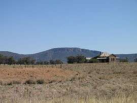 An abandoned homestead at Murga in front of the cliffs of Nangar National Park, as seen from the Escort Way | |
|
Murga | |
| Coordinates | 33°36′0″S 148°55′0″E / 33.60000°S 148.91667°ECoordinates: 33°36′0″S 148°55′0″E / 33.60000°S 148.91667°E |
| Population | 199 (2006 census)[1] |
| Postcode(s) | 2864 |
| Location | |
| LGA(s) | Cabonne Shire Council |
| State electorate(s) | Orange |
| Federal Division(s) | Calare |
Murga is a former town in the Central West region of New South Wales, Australia. The former town is located in the Cabonne Shire local government area, 320 kilometres (199 mi) west of the state capital, Sydney. At the 2006 census, Murga had a population of 199.[1]
Murga was once a stop at the Cobb and Co stagecoach line from Orange to Forbes. It was located below the cliffs of the Nangar Range, now the Nangar National Park, along the Mandagery Creek. By 1862 to town had a population of 100 people. With the end of the stagecoach era the town dwindled but remained a timber milling centre with its own school. Today nothing remains of Murga but the old post office which is now a private home.[2]
References
- 1 2 Australian Bureau of Statistics (25 October 2007). "Murga (State Suburb)". 2006 Census QuickStats. Retrieved 2013-04-01.
- ↑ Canowindra and district churches, authors: Berna Wright, Gwen Wythes, Dorothy Balcomb, published: 1988, ISBN 0959897534
External links
This article is issued from Wikipedia - version of the 4/8/2015. The text is available under the Creative Commons Attribution/Share Alike but additional terms may apply for the media files.