Muratlı
| Muratlı | |
|---|---|
 Muratlı | |
| Coordinates: TR 41°10′27″N 27°30′31″E / 41.17417°N 27.50861°ECoordinates: TR 41°10′27″N 27°30′31″E / 41.17417°N 27.50861°E | |
| Country |
|
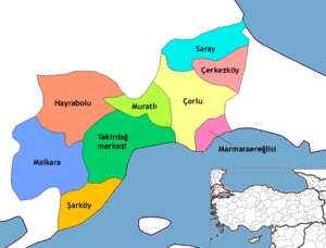
| Province | Tekirdağ |
| Government | |
| • Mayor | Nebi Tepe (DSP) |
| • Kaymakam | Mahmut Hersanlıoğlu |
| Area[1] | |
| • District | 426.75 km2 (164.77 sq mi) |
| Elevation | 92 m (302 ft) |
| Population (2012)[2] | |
| • Urban | 20,087 |
| • District | 26,341 |
| • District density | 62/km2 (160/sq mi) |
| Post code | 59700 |
| Website |
www |
Muratlı is a town and a district of Tekirdağ Province in the Marmara region of Turkey. It is located at 24 km north of the town of Tekirdağ and on the railway line from Istanbul to the Bulgarian border. It covers an area of 427 km², and the population is about 20,000. The district has hot summers and cold winters. The mayor is Nebi Tepe (DSP).
History
Muratlı is on the road from Istanbul to Edirne, the border between Turkey and Bulgaria so innumerable armies have passed through here in the course of history. One of them was led by the Ottoman Sultan Murat I, who liked the area as a watering hole so much he camped here.Therefore, the place was named after him,which is originally "Murateli" that means "under protection of Murat" . There have been settlements here for a long, long time and groundworks in the area often turn up copper and pottery artefacts.
Muratlı today
Despite having good flat farmland watered by the River Ergene, and the beginnings of industrial development too, Muratlı is insignificant and sandwiched between the larger towns of Tekirdağ and Çorlu. The town consists of one or two shopping streets, a couple of banks and the railway station. The town does have places selling the famous Tekirdağ köfte and plenty of locally produced wine can be found in the shops.
The people mainly live in cheaply built two-storey houses, the streets poorly paved. The population is the traditional Thracian rural mixture of the descendants of Turks that migrated from Bulgaria (in the early 20th century) and Gypsies.
Muratlı is three hours by train or two hours by bus from Istanbul.
Places of interest
- The railway station - built in 1870; the Orient Express passed through here between Istanbul and Europe.
- İnanlı Çeşmesi - a fountain built in 1914
- The house that Atatürk visited - in 1935 Atatürk ordered the construction of a settlement for Turkish refugees from Bulgaria and Romania. On 3 June 1936 he made a visit of inspection to one of the houses, commemorated by a plaque in the garden,which has "You lucky refugee don't forget 3rd of June,he became visitor to your house,he presented love to your all " written on it.
References
- ↑ "Area of regions (including lakes), km²". Regional Statistics Database. Turkish Statistical Institute. 2002. Retrieved 2013-03-05.
- ↑ "Population of province/district centers and towns/villages by districts - 2012". Address Based Population Registration System (ABPRS) Database. Turkish Statistical Institute. Retrieved 2013-02-27.
External links
hüseyin