Municipal Gardens, Aldershot

Municipal Gardens is an urban park in the town of Aldershot in Hampshire. A short walk from the town centre it has been a public park since 1904. In its ornamental garden is the Aldershot Cenotaph which commemorates the town's dead from both World Wars.
The Gardens

The Municipal Gardens are located on tracts of land purchased between 1894 and 1895 by Aldershot Urban District Council[1] from the Church's wardens and overseers for public use. After much discussion about price a settlement was agreed and work on the nearby Municipal Buildings and Gardens commenced.[2] This ancient piece of land, referred to as the 'Parish Clerk's Land' in the Crondall Hundred, was laid out as the Municipal Gardens and opened to the public in 1904.[3] On 'Arbour Day' on 13 December 1905 32 trees including lime, chestnut, acacia and sycamore were planted by their donors who were prominent local people.[1][4][5]
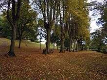
With its main entrance through restored Edwardian gates on Grosvenor Road, the Municipal Gardens are situated within the Aldershot West Conservation Area at the edge of the town centre. Entrances to the gardens are also located in Arlington Terrace and Laburnum Road. The park is set out in a typical late Victorian style, with pathways including an avenue shaded by mature trees and an ornamental garden with a modern water fountain and a wisteria pergola.[6]
From the 1980s until completion in 2004 the park underwent a number of improvements including adapting the former tennis courts into a hard court, restoring the historic path network and railings and installing a new fountain. The improvements have involved the work of various artists and craftspeople in the fields of stone lettering, mosaics and metal sculpture.[6] Bisected from the main area of the gardens by a pathway can be found a children's playground.
The Cenotaph


In the ornamental garden at the eastern end of the park is the Cenotaph[7] which was dedicated by Frank Woods, the Bishop of Winchester, and unveiled by Prince Henry, Duke of Gloucester in March 1925 in memory of those who gave their lives in World War I.[8][9] The memorial was formally presented to the Mayor of Aldershot by Mr F B Bateman of the Aldershot War Memorial Committee. The guard of honour at the unveiling was formed by detachments from every branch of the Service then at Aldershot Command.
The Cenotaph, which is made of Cornish granite, was originally flanked by two artillery pieces, one German and one Turkish dating from World War I. These were removed in 1940.[10][11]
An additional inscription was added in 1950 in remembrance of those who died during World War II.[12]
As Aldershot is a garrison town with a large population of serving soldiers and veterans the Cenotaph plays a key role in various acts of remembrance throughout the year such as a commemoration of the Battle of the Somme in 2016 [13] and the annual Remembrance Day.[14]
See also
References
- 1 2 Stephen Phillips and Gillian Picken, Aldershot Past Phillimore & Co Ltd (2000) pg 52
- ↑ Howard N. Cole, The Story of Aldershot: a History of the Civil and Military Towns, Gale & Polden, Aldershot (1951) pg 155
- ↑ Paul H. Vickers, Aldershot Through Time pg 80 - Google Books
- ↑ Cole, pg 166
- ↑ Vickers, pg 80
- 1 2 Regeneration of the Municipal Gardens on the Hampshire County Council website
- ↑ The Aldershot Cenotaph on War Memorials Online
- ↑ Stephen Phillips and Vivienne Owen, Images of Aldershot Breedon Book Publishing Company (1998) pg 69
- ↑ The Aldershot Cenotaph on the Imperial War Museums website
- ↑ Cole, pg 304
- ↑ Phillips and Owen, pg 570
- ↑ The Cenotaph in the Municipal Gardens - Hampshire War Memorials
- ↑ Municipal Gardens and Cenotaph - Royal British Legion website
- ↑ Municipal Gardens and play area on the Rushmoor Borough Council website
External links
- The Municipal Gardens on the Hampshire Gardens Trust website
- Municipal Gardens on the Pictures of England website
Coordinates: 51°14′51″N 0°46′08″W / 51.2474°N 0.7689°W