Munford, Alabama
| Munford, Alabama | |
|---|---|
| Town | |
|
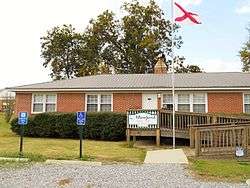
Munford Town Hall | |
 Location in Talladega County and the state of Alabama | |
| Coordinates: 33°32′0″N 85°57′15″W / 33.53333°N 85.95417°W | |
| Country | United States |
| State | Alabama |
| County | Talladega |
| Area | |
| • Total | 2.2 sq mi (5.7 km2) |
| • Land | 2.2 sq mi (5.7 km2) |
| • Water | 0 sq mi (0 km2) |
| Elevation | 640 ft (195 m) |
| Population (2010) | |
| • Total | 1,292 |
| • Density | 590/sq mi (230/km2) |
| Time zone | Central (CST) (UTC-6) |
| • Summer (DST) | CDT (UTC-5) |
| ZIP code | 36268 |
| Area code(s) | 256 |
| FIPS code | 01-52848 |
| GNIS feature ID | 0160206 |
Munford is a town in Talladega County, Alabama, United States.[1] At the 2010 census the population was 1,292.[2] It is the location of what has been called the last battle of the Civil War east of the Mississippi, the Battle of Munford on April 23, 1865, being one week after the Battle of Columbus (April 16, 1865) in Georgia.
History
Munford was initially incorporated in 1873.[3] At some point in the 1880s, it either disincorporated or lost its charter. In 2000, Munford was classified as a census-designated place (CDP), and in 2002 formally incorporated again.[4]
Geography
Munford is located at 33°32′1″N 85°57′15″W / 33.53361°N 85.95417°W (33.533494, -85.954242).[5]
According to the United States Census Bureau, the town has a total area of 2.2 square miles (5.7 km2), all land.[2]
Demographics
| Historical population | |||
|---|---|---|---|
| Census | Pop. | %± | |
| 1880 | 147 | — | |
| 2000 | 2,446 | — | |
| 2010 | 1,292 | −47.2% | |
| Est. 2015 | 1,259 | [6] | −2.6% |
| U.S. Decennial Census[7] 2013 Estimate[8] | |||
As of the census of 2010 there were 1,292 people, 492 households, and 355 families residing in the town. The population density was 587.3 people per square mile (226.7/km²). There were 554 housing units at an average density of 251.8 per square mile (97.2/km²). The racial makeup of the CDP was 82.4% White, 15.6% Black or African American, 0.5% Native American, 0.1% some other race, and 1.3% from two or more races. 1.0% of the population were Hispanic or Latino of any race.[9]
There were 492 households, out of which 40.2% had children under the age of 18 living with them, 49.0% were headed by married couples living together, 17.1% had a female householder with no husband present, and 27.8% were non-families. 24.0% of all households were made up of individuals, and 9.3% were someone living alone who was 65 years of age or older. The average household size was 2.63, and the average family size was 3.11.[9]
In the town the population was spread out with 26.6% under the age of 18, 9.1% from 18 to 24, 26.6% from 25 to 44, 25.3% from 45 to 64, and 12.4% who were 65 years of age or older. The median age was 37.1 years. For every 100 females there were 87.2 males. For every 100 females age 18 and over, there were 84.8 males.[9]
For the period 2007-2011, the estimated median annual income for a household in the town was $46,875, and the median income for a family was $50,278. Male full-time workers had a median income of $28,558 versus $25,809 for females. The per capita income for the CDP was $20,964. About 24.5 of families and 19.9% of the population were below the poverty line, including 32.8% of those under age 18 and 5.8% of those age 65 or over.[10]
Notable person
- Donald Stewart, U.S. Senator from 1978 to 1981
References
- ↑ U.S. Geological Survey Geographic Names Information System: Munford, Alabama
- 1 2 "Geographic Identifiers: 2010 Demographic Profile Data (G001): Munford town, Alabama". U.S. Census Bureau, American Factfinder. Retrieved January 23, 2013.
- ↑ Alabama (1873-01-01). Acts of the General Assembly of the State of Alabama. J. Boardman.
- ↑ "Munford | Encyclopedia of Alabama". Encyclopedia of Alabama. Retrieved 2016-04-11.
- ↑ "US Gazetteer files: 2010, 2000, and 1990". United States Census Bureau. 2011-02-12. Retrieved 2011-04-23.
- ↑ "Annual Estimates of the Resident Population for Incorporated Places: April 1, 2010 to July 1, 2015". Retrieved July 2, 2016.
- ↑ "U.S. Decennial Census". Census.gov. Retrieved June 6, 2013.
- ↑ "Annual Estimates of the Resident Population: April 1, 2010 to July 1, 2013". Retrieved June 3, 2014.
- 1 2 3 "Profile of General Population and Housing Characteristics: 2010 Demographic Profile Data (DP-1): Munford town, Alabama". U.S. Census Bureau, American Factfinder. Retrieved January 23, 2013.
- ↑ "Selected Economic Characteristics: 2007-2011 American Community Survey 5-Year Estimates (DP03): Munford town, Alabama". U.S. Census Bureau, American Factfinder. Retrieved January 23, 2013.
Coordinates: 33°32′01″N 85°57′15″W / 33.533494°N 85.954242°W
Municipalities and communities of Talladega County, Alabama, United States | ||
|---|---|---|
| Cities | 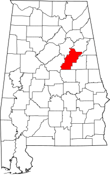 | |
| Towns | ||
| CDPs | ||
| Unincorporated communities | ||
| Ghost town | ||
| Footnotes | ‡This populated place also has portions in an adjacent county or counties | |