Mundy Regional Park
| Mundy Regional Park | |
|---|---|
|
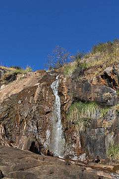
Lesmurdie Falls, located within the park | |
 | |
| Type | Regional park |
| Coordinates | 31°59′47″S 116°1′49″E / 31.99639°S 116.03028°ECoordinates: 31°59′47″S 116°1′49″E / 31.99639°S 116.03028°E |
| Area | 56 ha (138 acres)[1] |
| Established | 1957 |
| Operated by | Department of Parks and Wildlife |
| Website | Mundy Regional Park at Department of Parks and Wildlife |
The Mundy Regional Park is a regional park located on the western edge of the Darling Scarp, approximately 22 kilometres (14 mi) east of Perth in Western Australia. The 56-hectare (140-acre) park has commanding views of the Swan Coastal Plain, the city of Perth and surrounding suburbs.
Location and features
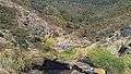
The park contains the 50-metre (164 ft) Lesmurdie Falls, formed by Lesmurdie Brook emptying over the Scarp, and the surrounding riparian and heath vegetation.[2] Wandoo, Jarrah and Marri trees can all be found within the park. A gravity hill exists near the carpark on Palm Terrace.
Gallery


See also
- Forrestfield, Western Australia
- Lesmurdie, Western Australia
- List of waterfalls of Western Australia
References
- ↑ "Department of Environment and Conservation 2009–2010 Annual Report". Department of Environment and Conservation. 2010: 48. ISSN 1835-114X.
- ↑ "About Australia - Lesmurdie Falls National Park". 2010. Retrieved 17 October 2010.
External links
- Mundy Regional Park - Department of Parks and Wildlife
-
 Media related to Mundy Regional Park at Wikimedia Commons
This article is issued from Wikipedia - version of the 8/31/2016. The text is available under the Creative Commons Attribution/Share Alike but additional terms may apply for the media files.