Mullum Mullum Creek Trail
| Mullum Mullum Creek Trail | |
|---|---|
|
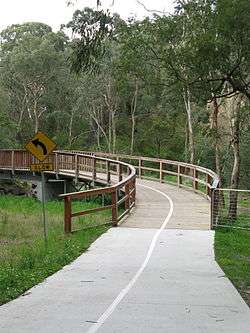
Mullum Mullum Creek Trail through Yarran Dheran | |
| Length | Upper 5.4km, lower 7.8km |
| Location | Melbourne, Victoria, Australia |
| Cycling details | |
| Trail difficulty | Easy |
| Hazards | Horses |
| Hills | Undulating |
| Connecting transport | |
| Train(s) | Ringwood station |
| Tram(s) | None |
The Mullum Mullum Creek Trail is a shared use path for cyclists and pedestrians, which follows Mullum Mullum Creek in the outer eastern suburbs in Melbourne, Victoria, Australia.[1][2][3]
The path is split into two sections, which will be linked to form one continuous trail from Templestowe to Croydon. Until this link is constructed, the section of the path between the end of the Yarra River Trail in Templestowe and Park Road in Donvale is the lower section, while the section between the end of the Heads Road in Donvale and Highland Avenue in Croydon is the upper section. The missing central section between Park Road and Heads Road in Donvale is set to open in 2017, with a detail planning study having been completed.
Following the path
Upper section
The upper section starts in the east at the end of Highland Ave. The path heads in a south westerly direction, with at-level road crossing at Kalinda Road, Oban Road, and Oliver Street. The trail then heads under the tunnel, where there is an immediate junction. Trail users can turn left, heading east toward the Belgrave Rail Trail, which initially runs on-road along Larissa Avenue and via Ringwood Lake. The Mullum Mullum Creek Trail takes an immediate right turn west towards Eastland Shopping Centre. A road crossing at Warrandyte Road and a tunnel under Ringwood Street sends you to the end of the EastLink Trail. Continuing under the EastLink onramps leads you under Deep Creek Road and into Yarran Dheran. The path continues north west past sensitive flora and fauna by the concrete path mixed with a series of timber bridges and boardwalks. An at-level crossing with Quarry Road is confronted before continuing west. The track ends at an unsigned future extension of the Mullum Mullum Creek Trail 80m west of Beckett Road. At this point, the path seamlessly becomes the Koonung Creek Trail, which takes users towards Doncaster and eventually the Melbourne CBD along the Eastern Freeway. Refer also to Mullum Mullum Creek and Mullum Mullum Creek Park
Central Section (Under Construction)
The section of trail between the unsigned extension 80m west of Beckett Road to Heads Road was opened in July 2014.[4] Following the trail from west of Becketts Road toward Heads Road, the trail takes you over a longer boardwalk before terminating at the single-lane road bridge at Heads Road.
The 1 km remaining 'missing link' of the Mullum Mullum Creek Trail from Heads Road to Park Road south, running along the boundary of Whitefriars College, has existed only as an informal dirt track for several years. Construction through this section has been delayed for various reasons, including the installation of new sewer main infrastructure along the corridor scheduled to take place in December 2016.[5] Manningham Council have recently undertaken enabling works at the Park Road end of the trail to allow construction to commence as soon as the sewerage works are completed.
At present, trail users wishing to travel from Schwerkolt Cottage to the lower section and to the Main Yarra Trail at Templestowe must detour, either by continuing along the EastLink Trail up to Park Road, continuing along Park Road to the Mullum Mullum Creek. Alternatively, trail users may utilise the Beckett Road to Heads Road section, turning up Heads Road, and then continuing down Park Road to the Mullum Mullum Creek. Due to the steep and narrow nature of Heads Road, in addition to lacking a footpath, trail users may wish to take the former detour.
Lower section
The lower section starts at Park Road and continues 8.5 km to the Main Yarra Trail and crosses Heidelberg - Warrandyte Road. On the far side is a wooden bridge and boardwalk - continue to the left - the right leads to a tea house at Beasley's Nursery.
After 1.1 km the path opens up into a more open area and meets the Greengully Trail that enters from the left (south). The intersection is badly signed. Continue past large open areas on the right (east) where Kangaroos/Wallabies can be seen on a regular basis, just 20 km from the Melbourne CBD.
The trail ends at the confluence of the Mullum Mullum Creek and the Yarra River in Templestowe. A lookout surveys the spot. The Main Yarra Trail starts here.
Connections
The upper section of the trail at Larissa Ave, Ringwood connects to the Belgrave Rail Trail. The northeastern end of the upper section finishes at Highland Ave, Croydon and has an on-road connection to the Tarralla Creek Trail. The northern end of the lower section connects to the Main Yarra Trail. The path also connects to the Greengully Trail 1.2 km south of the Yarra. The southern end of the lower section terminates at Park Rd.
Upper: West end at 37°48′15″S 145°12′16″E / 37.804200°S 145.204411°E.
East end at 37°47′07″S 145°15′51″E / 37.785142°S 145.264044°E.
Lower: North end at 37°44′18″S 145°09′43″E / 37.738386°S 145.161994°E.
South end at 37°46′32″S 145°11′26″E / 37.775679°S 145.190680°E.
Tarralla Creek Trail Connection
From Highland Ave, a 2.7 km road section, via Croydon station, can be used to reach the Tarralla Creek Trail. Continue on Highland Ave to the Maroondah Highway service lane, using the service lane to the Kent Ave intersection. Cross Maroondah Hwy at Kent Ave. Cyclists may utilise the on-road semi-protected bicycle lanes[6] on Kent Ave. Continue onto Main St, Croydon via the level crossing at the roundabout and Croydon War Memorial. Follow Main St to Hewish Rd, where the Tarralla Creek Trail begins at Croydon Park.
Belgrave Rail Trail Connection
Completed in 2013, the Maroondah Council project "Lake to Creek Link Project"[7] improves the link to Ringwood Lake and the Belgrave Rail Trail beyond. At Larissa Ave, follow the trail to the signalised pedestrian crossing of Maroondah Hwy where the trail enters Ringwood Lake. Continue 250m along the southern side of the lake to a narrow turnoff, taking you across the Belgrave railway line and into Bedford Park. Follow the driveway through Bedford Park to Bedford Rd, crossing Bedford Rd at the signalised intersection at the front of Ringwood Secondary College. The Belgrave Rail Trail begins at the southern end of Lena Grove.
References
- ↑ VicRoads - Bicycle Facilities Map
- ↑ Melbourne and Geelong's shared paths in Google Maps
- ↑ Melbourne and Geelong's shared paths in Google Earth
- ↑ Bicycle Network https://www.bicyclenetwork.com.au/general/policy-and-campaigns/2654/. Retrieved 18 October 2016. Missing or empty
|title=(help) - ↑ Yarra Valley Water - Donvale Sewerage Project - Package F http://www.yvw.com.au/Home/Inyourcommunity/Worksinyourarea/YVW1004156. Retrieved 18 October 2016. Missing or empty
|title=(help) - ↑ Maroondah Bicycle Users Group http://maroondahbug.info/better-conditions/kent-ave-safety-improvements/. Retrieved 18 October 2016. Missing or empty
|title=(help) - ↑ Lake to Creek Link Project
- Manningham Leader - grant
- Bike rides around Melbourne 3rd edition, 2009, Julia Blunden, Open Spaces Publishing, ISBN 978-0-9752333-4-4
- Bike Paths Victoria sixth edition, 2004. Edited and published by Sabey & Associates Pty Ltd. pp127. ISBN 0-9579591-1-7
External links
- Maroondah BUG - Mullum Mullum Creek Trail
- Yarran Dheran
- Friends of Mullum Mullum Valley
 Geographic data related to Mullum Mullum Creek Trail at OpenStreetMap