Muirhead
| Muirhead | |
| Scottish Gaelic: Ceann a' Mhonaidh[1] | |
| Scots: Mairheid | |
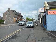 The Main Street in Muirhead |
|
 Muirhead |
|
| OS grid reference | NS67SE60 |
|---|---|
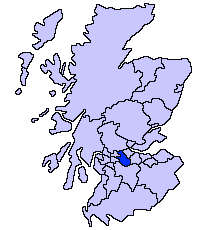
| Council area | North Lanarkshire |
| Lieutenancy area | Lanarkshire |
| Country | Scotland |
| Sovereign state | United Kingdom |
| Post town | GLASGOW |
| Postcode district | G69 |
| Police | Scottish |
| Fire | Scottish |
| Ambulance | Scottish |
| EU Parliament | Scotland |
| UK Parliament | Coatbridge, Chryston and Bellshill |
| Scottish Parliament | Coatbridge and Chryston |
Coordinates: 55°53′53″N 4°06′22″W / 55.898°N 4.106°W
Muirhead is a small suburb approximately 7 miles (11 km) North-East of Glasgow city centre. Nearby villages and towns include Chryston, Garnkirk, Gartcosh, Lenzie and Stepps. Muirhead has a population of 1,410 according to the 2011 Census.
It is a commuter town to Glasgow with road links with the A80/M80 and frequent bus services the 36, x37, x39 and x3. Muirhead is located approximately two miles from Gartcosh, Lenzie and Stepps railway stations.
The suburb has a variety of shops including a Co-operative Food, newsagents, butcher, stationers and plenty of take-away food shops. Two bars which serve the area are the Muirhead Inn and The Crowwood.
The surrounding area has one high school and two primary schools.
A local development to the south of the village is Belhaven Park.
References
| Wikimedia Commons has media related to Muirhead. |