Mueang Chai Nat District
| Mueang Chai Nat เมืองชัยนาท | |
|---|---|
| Amphoe | |
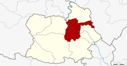 Amphoe location in Chai Nat Province | |
| Coordinates: 15°11′8″N 100°7′26″E / 15.18556°N 100.12389°ECoordinates: 15°11′8″N 100°7′26″E / 15.18556°N 100.12389°E | |
| Country |
|
| Province | Chai Nat |
| Seat | Nai Mueang |
| Area | |
| • Total | 255.377 km2 (98.602 sq mi) |
| Population (2008) | |
| • Total | 72,031 |
| • Density | 286.6/km2 (742/sq mi) |
| Time zone | THA (UTC+7) |
| Postal code | 17000 |
| Geocode | 1801 |
Mueang Chai Nat (Thai: เมืองชัยนาท) is the capital district (Amphoe Mueang) of Chai Nat Province, central Thailand.
Geography
Neighbouring districts are (from the east clockwise) Sapphaya, Sankhaburi, Hankha, Wat Sing, Manorom of Chainat Province and Takhli of Nakhon Sawan Province.
History
In 1917 the district was renamed from Mueang to Ban Kluai (บ้านกล้วย).[1] In 1938 it got the name Mueang Chai Nat.[2]
Administration
The district is subdivided into 9 subdistricts (tambon), which are further subdivided into 81 villages (muban). Chainat is a town (thesaban mueang) which covers the whole tambon Nai Mueang and parts of Ban Kluai, Tha Chai and Khao Tha Phra. There are further 8 Tambon administrative organizations (TAO).
| No. | Name | Thai | Villages | Inh.[3] |
|---|---|---|---|---|
| 1. | Nai Mueang | ในเมือง | - | 5,861 |
| 2. | Ban Kluai | บ้านกล้วย | 7 | 13,379 |
| 3. | Tha Chai | ท่าชัย | 11 | 8,801 |
| 4. | Chai Nat | ชัยนาท | 9 | 8,259 |
| 5. | Khao Tha Phra | เขาท่าพระ | 7 | 7,552 |
| 6. | Hat Tha Sao | หาดท่าเสา | 8 | 5,031 |
| 7. | Thammamun | ธรรมามูล | 10 | 7,547 |
| 8. | Suea Hok | เสือโฮก | 14 | 7,682 |
| 9. | Nang Lue | นางลือ | 15 | 7,919 |
References
- ↑ ประกาศกระทรวงมหาดไทย เรื่อง เปลี่ยนชื่ออำเภอ (PDF). Royal Gazette (in Thai). 34 (0 ก): 40–68. 1917-04-29.
- ↑ พระราชกฤษฎีกาเปลี่ยนนามจังหวัด และอำเภอบางแห่ง พุทธศักราช ๒๔๘๑ (PDF). Royal Gazette (in Thai). 55 (0 ก): 658–666. 1938-11-14.
- ↑ "Population statistics 2008". Department of Provincial Administration.
External links
- amphoe.com (Thai)
This article is issued from Wikipedia - version of the 11/20/2016. The text is available under the Creative Commons Attribution/Share Alike but additional terms may apply for the media files.