Arta Mountains
| Arta Mountains | |
|---|---|
 | |
| Highest point | |
| Peak | Arta |
| Elevation | 755 m (2,477 ft) |
| Naming | |
| Nickname | The Great Mountains of Arta |
| Geography | |
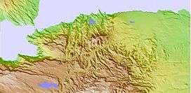 Map of The Mountains of Arta | |
| Country | Djibouti |
| State/Province | Arta Region |
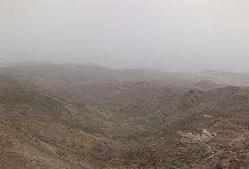
The Arta Mountains, also known as the Great Mountains of Arta, are a mountain range in Djibouti. They sit at an average elevation of 700 metres (2,300 ft) above sea level. The mountains lie to the south of the Gulf of Tadjoura, in the Arta Region. They are situated approximately 35 kilometres (21 mi) west of the capital Djibouti City, and 69 kilometres (43 mi) by road from Ali Sabieh. The Issa Somali have a long history in the Arta Mountains.
History
The first known people that inhabited the mountain are the Issa Somali. The most famous town in the area is the town of Arta. The French people in Djibouti travelled here when Djibouti city is difficult because of the heat in the summer.
Climate
Elevation is a major factor in temperature levels. Higher areas, on average, are 11 °C (20 °F) cooler, day or night. Overnight lows sometimes necessitate heavy clothes or blankets; particularly in the highlands, when the temperature drops to about 50–54 °F (10–12.2 °C) every night. The Mountains of Arta have a mixture of highland climate zones, with temperature differences of up to 10 °C, depending on elevation and prevailing wind patterns. The range's climate is semi-desert hot during summer and cold in the winter. Its rainy season extends from mid-Jan to mid-April. From November to February, the area experiences the cool winter season. It also heats up with cool winds from June to September.
| Climate data for Arta Mountain | |||||||||||||
|---|---|---|---|---|---|---|---|---|---|---|---|---|---|
| Month | Jan | Feb | Mar | Apr | May | Jun | Jul | Aug | Sep | Oct | Nov | Dec | Year |
| Average high °C (°F) | 24.5 (76.1) |
24.7 (76.5) |
26.7 (80.1) |
29.2 (84.6) |
33 (91) |
37.2 (99) |
37.4 (99.3) |
36.4 (97.5) |
34.3 (93.7) |
30 (86) |
26.9 (80.4) |
25.2 (77.4) |
30.46 (86.8) |
| Average low °C (°F) | 15.6 (60.1) |
16.7 (62.1) |
18 (64) |
20.5 (68.9) |
23.7 (74.7) |
27.4 (81.3) |
26.1 (79) |
25.5 (77.9) |
25.6 (78.1) |
20.6 (69.1) |
17.8 (64) |
16.3 (61.3) |
21.15 (70.04) |
| Average precipitation mm (inches) | 29 (1.14) |
25 (0.98) |
24 (0.94) |
29 (1.14) |
14 (0.55) |
1 (0.04) |
11 (0.43) |
22 (0.87) |
16 (0.63) |
11 (0.43) |
37 (1.46) |
14 (0.55) |
233 (9.16) |
| Source: Climate-Data.org, altitude: 755m[1] | |||||||||||||
See also
References
- ↑ "Climate: Arta - Climate graph, Temperature graph, Climate table". Climate-Data.org. Retrieved 25 September 2013.
- United States Bureau of Mines, Geological Survey (2000). Minerals Yearbook, Volume 3. The Bureau. pp. 12–1.