Mountaindale, Oregon
| Mountaindale, Oregon | |
|---|---|
| Unincorporated community | |
|
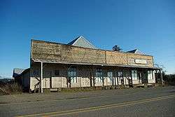
Former Mountaindale Store at Mountaindale and Dairy Creek roads | |
 Mountaindale, Oregon  Mountaindale, Oregon Location within the state of Oregon | |
| Coordinates: 45°37′29″N 123°02′20″W / 45.62472°N 123.03889°WCoordinates: 45°37′29″N 123°02′20″W / 45.62472°N 123.03889°W | |
| Country | United States |
| State | Oregon |
| County | Washington |
| Elevation | 194 ft (59 m) |
| Time zone | Pacific (PST) (UTC-8) |
| • Summer (DST) | PDT (UTC-7) |
| ZIP codes | 97133 |
| Area code(s) | 503 and 971 |
| GNIS feature ID | 1163167[1] |
Mountaindale is an unincorporated community in Washington County, Oregon, United States, about four miles northwest of North Plains.[2] Settled in the 1850s, the small community was the longtime home of the Mountaindale Store. The area is part of Washington County Fire District 2.[3]
History
The Atfalati tribe of Native Americans had a seasonal campsite in the area prior to the arrival of European-Americans in the 1830s.[4] The first Euro-American settlers in the Mountaindale area were Samuel B. and Mary Raffety, who in 1852 traveled the Oregon Trail to the Oregon Territory and settled a donation land claim in northern Washington County in the foothills of the Oregon Coast Range.[5] Originally from Kentucky, they raised eight children on their 320-acre (130 ha) farm.[5] One child, Charles H. Raffety, later served as mayor of East Portland before its annexation into Portland.[5] Mountaindale School District 41 was formed on December 5, 1868, with Alzada Cornelius as the first teacher and W. D. Pittenger as the first superintendent.[5] The school was built at that time and was located on the Dobbins land claim.[6] The store was later built in front of the school.[6] The post office was established in 1873 as "Mountain Dale" and the name was changed to "Mountaindale" in 1895.[7][8] The name combining "mountain" and "dale" is descriptive, as the community is where East Fork Dairy Creek emerges from the foothills at the north edge of the Tualatin Valley.[7]

In 1885,[9] a new schoolhouse was built for $200.[5] It was 30 feet (9.1 m) long, 13 feet (4.0 m) wide, and 12 feet (3.7 m) tall.[5] The new school was originally known as the Raffety School as it was built on land donated by Samuel Raffety.[6] Charles Reynolds opened the first store in the community in 1896.[5] In 1904, a new Mountaindale Store was built across the street from the original.[5] Reynolds also operated a freight line and a blacksmith shop.[5] In 1915, Mountaindale had two sawmills,[9] and much of the area surrounding area was logged.[4]
The Mountaindale post office closed in 1935.[7] In February 1953, the school district was merged into the North Plains School District (originally known as the Glencoe district), which merged into the Hillsboro School District in 1996.[6][10] The Mountaindale school remained in use until 1954 or 1955, and by 1976 was owned by the Stohr family.[6][9]
In 1990, the only public buildings remaining in the community were the store and the closed schoolhouse.[9] The store is also now closed.
The Mountaindale Airport is a mile southwest of the community.
References
- ↑ "Mountaindale, Oregon". Geographic Names Information System. United States Geological Survey.
- ↑ "Mountaindale". Geographic Names Information System. United States Geological Survey. November 28, 1980. Retrieved 2010-01-26.
- ↑ "County Bridges & Fire District Boundaries." (PDF). Washington County. Retrieved June 23, 2014.
- 1 2 Buan, Carolyn M. This Far-Off Sunset Land: A Pictorial History of Washington County, Oregon. Donning Company Publishers, 1999. p. 18, 38.
- 1 2 3 4 5 6 7 8 9 "Communities: Mountaindale early history retraced to 1852 land grant". Hillsboro Argus. October 19, 1976. p. 5.
- 1 2 3 4 5 Philpott, Betty (October 19, 1976). "Schools and Churches: Interest in history spurs preservation of school". Hillsboro Argus. p. 9.
- 1 2 3 McArthur, Lewis A.; McArthur, Lewis L. (2003) [1928]. Oregon Geographic Names (7th ed.). Portland, Oregon: Oregon Historical Society Press. p. 680. ISBN 978-0875952772.
- ↑ Benson, Robert L. (October 19, 1976). "Business and Industry: Post offices, zip codes listed". Hillsboro Argus. p. 11.
- 1 2 3 4 Friedman, Ralph (1990). In Search of Western Oregon (2nd ed.). Caldwell, Idaho: The Caxton Printers, Ltd. p. 150. ISBN 0-87004-332-3.
- ↑ Benson, Robert L. (October 19, 1976). "Historic Potpourri: Courthouse fire destroys school records in '20s". Hillsboro Argus. p. 10.
External links
 Media related to Mountaindale, Oregon at Wikimedia Commons
- Historic image of general store in Mountaindale from Salem Public Library
Municipalities and communities of Washington County, Oregon, United States | ||
|---|---|---|
| Cities |  | |
| CDPs | ||
| Unincorporated communities |
| |
| Ghost towns | ||
| Footnotes | ‡This populated place also has portions in an adjacent county or counties | |