Mountain Top, Pennsylvania
| Mountain Top | |
|---|---|
| Census-designated place | |
|
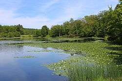
Blue Giant Meadow Lake in Mountain Top | |
 Mountain Top Location within the state of Pennsylvania | |
| Coordinates: 41°8′7″N 75°54′16″W / 41.13528°N 75.90444°WCoordinates: 41°8′7″N 75°54′16″W / 41.13528°N 75.90444°W | |
| Country | United States |
| State | Pennsylvania |
| County | Luzerne |
| Area | |
| • Total | 15.1 sq mi (39.0 km2) |
| • Land | 15.1 sq mi (39.0 km2) |
| • Water | 0 sq mi (0 km2) |
| Population (2010) | |
| • Total | 10,982 |
| • Density | 730/sq mi (280/km2) |
| Time zone | Eastern (EST) (UTC-5) |
| • Summer (DST) | EDT (UTC-4) |
| ZIP code | 18707 |
| Area code(s) | 570 and 272 |
Mountain Top is a census-designated place (CDP) in Luzerne County, Pennsylvania, in the United States. As of the 2010 census, the CDP population was 10,982.[1]
Mountain Top is located along Pennsylvania Route 309 south of Wilkes-Barre in Fairview Township, Wright Township and a small part of Rice Township.
Name
Though it is generally accepted that the area's proper name is "Mountain Top", there has been some debate about whether it should actually be "Mountaintop". The local historical society uses the spelling "Mountain Top".[2] The United States Postal Service uses the spelling "Mountain Top" for ZIP Code 18707, and the Pennsylvania Department of Transportation spells it Mountain Top on a Pennsylvania driver's license. The local newspaper, however, the Mountaintop Eagle,[3] uses the Mountaintop spelling in both its title as well as any reference to its location.
Geography

Mountain Top, once named Penobscot, PA is located at 41°8′7″N 75°54′16″W / 41.13528°N 75.90444°W (41.1353022, -75.9044749) in the shadow of Mount Penobscot (or Penobscot Knob). According to the United States Census Bureau, the CDP has a total area of 15.1 square miles (39.0 km2), all of it land.[4]
Mountain Top is located in the saddle pass atop the drainage divide between the Susquehanna River basin to the north and west and the Lehigh River basin to the east and south, so sits astride an important land communications corridor bridging the two watersheds below. It is just 8 miles (13 km) northwest of White Haven at the head end of the Lehigh River gorge and in the heights above Hazleton, Pennsylvania only 10 miles (16 km) south of Wilkes-Barre on Pennsylvania Route 309. Consequently, even though regional railroads are much diminished in scope and influence, Mountain Top yard, once used as a marshaling yard at the top of the Ashley Planes funicular (cable driven) railway, is still an important regional element of the transportation infrastructure connecting Allentown and Philadelphia with points north and west via trackage to several yards in New York State.
Mountain Top is elevated at 1,558 feet (475 m) above sea level.
Demographics
As of the census[5] of 2000, there were 15,269 people, 5,556 households, and 4,394 families residing in the CDP. The population density was 224.0 people per square mile (86.5/km2). There were 5,774 housing units at an average density of 84.7/sq mi (32.7/km2). The racial makeup of the CDP was 97.02% White, 0.54% African American, 0.03% Native American, 1.62% Asian, 0.24% from other races, and 0.56% from two or more races. Hispanic or Latino of any race were 1.08% of the population.
There were 5,556 households, out of which 36.8% had children under the age of 18 living with them, 68.2% were married couples living together, 8.1% had a female householder with no husband present, and 20.9% were non-families. 18.4% of all households were made up of individuals, and 8.5% had someone living alone who was 65 years of age or older. The average household size was 2.72 and the average family size was 3.10.
In the CDP the population was spread out, with 26.0% under the age of 18, 6.0% from 18 to 24, 28.7% from 25 to 44, 25.7% from 45 to 64, and 13.6% who were 65 years of age or older. The median age was 39 years. For every 100 females there were 95.5 males. For every 100 females age 18 and over, there were 92.9 males.
The median income for a household in the CDP was $51,655, and the median income for a family was $58,588. Males had a median income of $41,271 versus $26,346 for females. The per capita income for the CDP was $22,480. About 2.9% of families and 3.4% of the population were below the poverty line, including 3.7% of those under age 18 and 5.4% of those age 65 or over.
Education
Mountain Top is located in the Crestwood Area School District which covers over 110 square miles (280 km2). In this area is included Dennison Township, Dorrance Township, Fairview Township, Nuangola Borough, Rice Township, Slocum Township, White Haven Borough, Wright Township, and Penn Lake Borough.
The Crestwood School District consists of four schools:
- Rice Elementary School - Rice Township (Grades K-6). The principal is Kevin Seyer.
- Fairview Elementary School - Fairview Township (Grades K-6)
- Crestwood Middle School - Mountain Top (Grades 7 and 8) The teaching teams are Wildcats, Thunderbees, Red team, and White team.
- Crestwood High School - Mountain Top (Grades 9-12).
St. Jude's Catholic School in Wright Township serves grades K-8, after which students can continue Catholic education by attending Holy Redeemer High School in Wilkes-Barre, or can enter Crestwood High School.
References
- ↑ "Profile of General Population and Housing Characteristics: 2010 Demographic Profile Data (DP-1): Mountain Top CDP, Pennsylvania". U.S. Census Bureau, American Factfinder. Retrieved April 27, 2012.
- ↑ "Mountain Top Historical Society". Archived from the original on 2005-03-22. Retrieved 2012-10-16.
- ↑ "The Mountaintop Eagle". Mteagle.com. Retrieved 2012-10-16.
- ↑ "Geographic Identifiers: 2010 Demographic Profile Data (G001): Mountain Top CDP, Pennsylvania". U.S. Census Bureau, American Factfinder. Retrieved April 27, 2012.
- ↑ "American FactFinder". United States Census Bureau. Retrieved 2008-01-31.
External links
- Mountain Top Historical Society
- Mountaintop On The Move, volunteer community organization
- NEPA309.Com, live-motion camera view of Route 309 in Mountain Top
- Crestwood School District
- Crestwood High School
- Mountaintop Eagle Newspaper
Municipalities and communities of Luzerne County, Pennsylvania, United States | ||
|---|---|---|
| Cities | 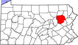 | |
| Boroughs |
| |
| Townships | ||
| CDPs | ||
| Unincorporated communities |
| |
| Footnotes | ‡This populated place also has portions in an adjacent county or counties | |