Mount Wellington (Tasmania)
| Mount Wellington | |
|---|---|
|
kunanyi / Mount Wellington[1] Unghbanyahletta or Poorawetter[2] | |
|
| |
| Highest point | |
| Elevation | 1,269 m (4,163 ft) [3] |
| Prominence | 693 m (2,274 ft) [3] |
| Isolation | 47.56 km (29.55 mi) [3] |
| Listing | 49th highest mountain of Tasmania |
| Coordinates | 42°53′24″S 147°13′48″E / 42.89000°S 147.23000°ECoordinates: 42°53′24″S 147°13′48″E / 42.89000°S 147.23000°E [4] |
| Geography | |
 Mount Wellington Location in Tasmania | |
| Location | South East Tasmania, Australia |
| Parent range | Wellington |
| Geology | |
| Mountain type | Dolerite |
| Climbing | |
| First ascent |
|
| Easiest route | Hike, road |
Mount Wellington, officially known as kunanyi / Mount Wellington[1] (Aboriginal: Unghbanyahletta or Poorawetter[2]), is a mountain in the southeast coastal region of Tasmania, Australia. The mountain is the summit of the Wellington Range on whose foothills is built much of the city of Hobart.
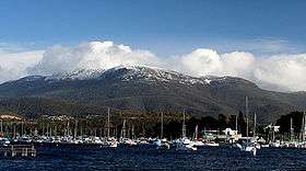
The mountain rises to 1,269 metres (4,163 ft) above sea level[3] and is frequently covered by snow, sometimes even in summer, and the lower slopes are thickly forested, but criss-crossed by many walking tracks and a few fire trails.[5] There is also a sealed narrow road to the summit, about 22 kilometres (14 mi) from Hobart central business district. An enclosed lookout near the summit provides spectacular views of the city below and to the east, the Derwent estuary, and also glimpses of the World Heritage Area nearly 100 kilometres (62 mi) west.
From Hobart, the most distinctive feature of Mount Wellington is the cliff of dolerite columns known as the Organ Pipes. It has extensive views of Hobart and is one of the city's biggest tourist destinations.
Geology

The low-lying areas and foothills of Mount Wellington were formed by slow geological upsurge when the whole Hobart area was a low-lying cold shallow seabed. The upper reaches of the mountain were formed more violently, as a Sill with a tabular mass of igneous rock that has been intruded laterally between layers of older rock pushing upwards by upsurges of molten rock as the Australian continental shelf tore away from Antarctica, and separated from Gondwana over 40 million years ago. It is often incorrectly considered to be a dormant volcano.
Indigenous history
Mount Wellington was originally referred by the original Tasmanian nations of the area as Unghbanyahletta (or Ungyhaletta), Poorawetter (or ‘'Pooranetere'’, also Pooranetteri),[2] or Kunanyi to the indigenous people of Tasmania. The Palawa, the surviving descendants of the original indigenous Tasmanians, tend to prefer the latter name. In 2013, a Tasmanian dual naming policy was announced and "kunanyi / Mount Wellington" was named as one of the inaugural dual named geographic features.[1][6]
European history
The first recorded European in the area Abel Tasman probably did not see the mountain in 1642, as his ship was quite a distance out to sea as he sailed up the South East coast of the island - coming closer in near present-day North and Marion Bays.
No other Europeans visited Tasmania until the late eighteenth century, when several visited southern Tasmania (then referred to as Van Diemens Land) including Frenchman Marion du Fresne (1772), Englishmen Tobias Furneaux (1773), James Cook (1777) and William Bligh (1788 and 1792), and Frenchman Bruni d'Entrecasteaux (1792–93). In 1793 Commodore John Hayes arrived at the Derwent River, naming the mountain Skiddaw, after the mountain in the Lake District, although this name never gained popularity.
In 1798 Matthew Flinders and George Bass circumnavigated the island. Whilst they were resting in the area Flinders named the river the Derwent River (the name John Hayes had given only to the upper part of the river),[7] Flinders referred to the mountain as ‘Table Mountain’ (the name given to it by Bond and Bligh - young Matthew Flinders was with them in 1791) for its similarity in appearance to Table Mountain in South Africa. Bruni d'Entrecasteaux's men were the first European to sail up the river and chart it. Later Nicholas Baudin led another French expedition in 1802, and whilst sheltering in the Derwent River (which they referred to as ‘River du Nord’ - the name d'Entrecasteaux had given to it) Baudin also referred to the mountain as ‘Montagne du Plateau’ (also named by d'Entrecasteaux). However, the British first settled in the Hobart area in 1804, resulting in Flinders’ name of ‘Table Mountain’ becoming more popular. Table Mountain remained its common name until in 1832 it was decided to rename the mountain in honour of the Duke of Wellington who, with Gebhard Leberecht von Blücher finally defeated Napoleon at the Battle of Waterloo in present-day Belgium on 18 June 1815.

In February 1836, Charles Darwin visited Hobart Town and climbed Mount Wellington. In his book "The Voyage of the Beagle", Darwin described the mountain thus;
"... In many parts the Eucalypti grew to a great size, and composed a noble forest. In some of the dampest ravines, tree-ferns flourished in an extraordinary manner; I saw one which must have been at least twenty feet high to the base of the fronds, and was in girth exactly six feet. The fronds forming the most elegant parasols, produced a gloomy shade, like that of the first hour of the night. The summit of the mountain is broad and flat, and is composed of huge angular masses of naked greenstone. Its elevation is 3,100 feet [940 m] above the level of the sea. The day was splendidly clear, and we enjoyed a most extensive view; to the north, the country appeared a mass of wooded mountains, of about the same height with that on which we were standing, and with an equally tame outline: to the south the broken land and water, forming many intricate bays, was mapped with clearness before us. ..."
The first weather station was set up on Mount Wellington in 1895 by Clement Lindley Wragge.
Mount Wellington has played host to some notorious characters over time, especially the bushranger 'Rocky' Whelan, who murdered several travelers in the middle of the 19th century. The cave where he lived is known appropriately as 'Rocky Whelan's Cave', and is an easy walk from the Springs.[8]
Development


Throughout the 19th and into the 20th centuries, the Mountain was a popular day-resort for residents of Hobart. To that end, many excursion huts were built over the lower slopes of the mountain. However, none of these early huts survive as they were all destroyed during the disastrous bushfires of 1967, though modern huts are open to the public at the Springs, the Pinnacle, the Chalet - a picnic spot about halfway between the Springs and the Pinnacle - and elsewhere.[9] Sadly, many of the more remote huts have suffered from vandalism, and some are in virtually derelict condition.
The road to the summit was constructed in the early 1930s as a relief scheme for the unemployed, an idea initiated by Albert Ogilvie, the Premier of Tasmania of the day. While the road is officially known as the Pinnacle Drive, it was, for some time, also widely known among residents of Hobart as 'Ogilvie's Scar' because at the time it was constructed 'the Mountain' was heavily logged and almost bare, and the road was an all-too-obvious scar across the already denuded mountain. Today the trees have grown again but the 'scar' most people see today is not actually the road but a line of large rocks with no trees 50–100 m above the road, provided as an easement for power lines. The road itself was opened in August 1937, after nearly two years of work, by Governor Sir Ernest Clark.[10]
The road carries tourist traffic during the day and sections may be closed at any time of the year due to snowfalls or icy conditions. Halfway up this road (around 700 metres) is a picnic area called "The Springs", near the site of a chalet/health spa that was destroyed by bushfire in 1967.
Mount Wellington was selected by many broadcasters as the site of broadcast radio and television transmitters because it provides line-of-sight transmission to a much larger area of Hobart and surrounding districts than any other point in the region. The first television stations to transmit from there were TVT-6 (now WIN Television) and ABT-2 (the ABC) in 1960. The mountain has two main transmission towers located at its pinnacle. One is the concrete and steel constructed Broadcast Australia Tower (sometimes referred to as the NTA Tower) and one owned by WIN television which is of steel construction. The NTA tower broadcasts all of Hobart's high power FM radio stations plus the digital TV services for ABC and SBS. The NTA tower also has a small accommodation area at its base with kitchen and workshop area. The WIN TV tower broadcasts the digital TV services from Southern Cross, Win TV, and Tasmanian Digital Television. The site also contains a small kitchen area and contains some data links from local Hobart businesses. An amateur radio repeater is also installed on the mountain.


Cable car proposals
An aerial cableway (cable car) has been proposed for the mountain on four occasions.
The first two of these pre-dated the construction of Pinnacle Road. In 1905, Arnold Wertheimer proposed the construction of an aerial cableway (at the time referred to as an "aerial railway") from The Springs to the Pinnacle of Mt Wellington,[11][12] and in 1906 established The Mount Wellington Aerial Railway Company Ltd.[13] This proposal was soon modified to run from Cascades to the pinnacle,[14] but in the end never eventuated.
The concept was shelved until 1931, when an Aerial Tramway proposal involving a nine-minute journey from The Springs to the pinnacle was publicised.[15] Included in this was a kiosk and observation deck, as well as the potential to provide for skiing on the slopes at the rear of the mountain.
After construction of Pinnacle Road was completed in 1937, momentum for an aerial cableway slowed. While general access to the pinnacle was easily available, justification for later cableway developments included the inability to access the pinnacle on periods of high snowfall;[16] the growth of Tasmania as a tourism destination;[16] and, since the increase of climate change awareness in the later parts of the 20th century, the environmental impact of motor vehicle pollution.
The next proposal did not come forward until 1987, when the first of three proposals by Hobart engineer Tim Burbury was announced. The 1987 proposal, by Burbury's company Trinity Projects, was to feature a hotel on the pinnacle serviced by a cable car based at Fern Tree. The public opposition was high enough that the plan was dropped before it went into detailed design.[17] In 1993, Burbury relaunched a modified proposal, estimated to cost A$31 million, known as Skyway. It featured a change of base location, to a hill near Cascade Brewery, and used two high capacity carriages to transport passengers.[18] At the pinnacle, the hotel proposal was dumped for a restaurant, and added a ski field at the rear of the mountain. Again, there was strong public opposition to this plan - including a reduction of privacy of residents near the lower part of the cable car, and destruction of the natural alpine environment.[17] The third revision of Burbury's plan was announced in 2004, including an alternate route, change from a large carriage to a series of smaller gondolas, a modified pinnacle centre design and removal of the ski field component of the project.[18][19]
_-_11.jpg)
After Burbury's death in 2010, Hobart businessman and entrepreneur Adrian Bold took on a renewed focus to develop a cable car solution for Mt Wellington. After several years of public consultation and preliminary design, this culminated in a formal launch in April 2014 of a two-part route from Cascade Brewery to a pinnacle centre at the summit, including a restaurant, café and function centre.[20] The proponent's partner, Toronto-based company BullWheel International, announced in November 2015, that it no longer had any involvement with the cable car proposal.[21]
Climate
Mount Wellington has a Tundra Climate (Köppen: ET ). The mountain significantly influences Hobart's weather, and intending visitors to the summit are advised to dress warmly against the often icy winds at the summit, which have been recorded at sustained speeds of over 157 kilometres per hour (98 mph), with rare gusts of up to 200 kilometres per hour (120 mph). In the winter it frequently snows and the mountain is often snowcapped. Lighter snowfalls in spring, summer and autumn are also common. A day on the summit can consist of clear sunny skies, then rain, then snow, then icy winds and then clear again.
| Climate data for Mount Wellington | |||||||||||||
|---|---|---|---|---|---|---|---|---|---|---|---|---|---|
| Month | Jan | Feb | Mar | Apr | May | Jun | Jul | Aug | Sep | Oct | Nov | Dec | Year |
| Record high °C (°F) | 29.8 (85.6) |
29.6 (85.3) |
26.1 (79) |
24.7 (76.5) |
14.9 (58.8) |
13.3 (55.9) |
9.8 (49.6) |
13.4 (56.1) |
19.5 (67.1) |
22.0 (71.6) |
26.2 (79.2) |
27.6 (81.7) |
29.8 (85.6) |
| Average high °C (°F) | 13.4 (56.1) |
13.7 (56.7) |
11.4 (52.5) |
8.4 (47.1) |
5.6 (42.1) |
3.6 (38.5) |
2.4 (36.3) |
2.8 (37) |
4.5 (40.1) |
7.1 (44.8) |
9.4 (48.9) |
11.0 (51.8) |
7.8 (46) |
| Average low °C (°F) | 4.7 (40.5) |
5.4 (41.7) |
4.1 (39.4) |
2.2 (36) |
0.6 (33.1) |
−0.7 (30.7) |
−1.5 (29.3) |
−1.7 (28.9) |
−1.2 (29.8) |
0.0 (32) |
1.6 (34.9) |
2.8 (37) |
1.4 (34.5) |
| Record low °C (°F) | −3.4 (25.9) |
−7.4 (18.7) |
−4.7 (23.5) |
−6.5 (20.3) |
−8.1 (17.4) |
−7.5 (18.5) |
−8.1 (17.4) |
−7.8 (18) |
−9.1 (15.6) |
−7.7 (18.1) |
−6.2 (20.8) |
−4.4 (24.1) |
−9.1 (15.6) |
| Average precipitation mm (inches) | 91.2 (3.591) |
78.9 (3.106) |
75.9 (2.988) |
88.9 (3.5) |
65.4 (2.575) |
76.4 (3.008) |
72.1 (2.839) |
89.2 (3.512) |
69.9 (2.752) |
77.9 (3.067) |
85.8 (3.378) |
89.1 (3.508) |
960.7 (37.824) |
| Average precipitation days | 16.7 | 15.3 | 17.1 | 18.3 | 18.9 | 16.9 | 19.0 | 17.6 | 18.6 | 19.1 | 18.3 | 19.5 | 215.3 |
| Average relative humidity (%) | 74 | 75 | 79 | 83 | 87 | 90 | 93 | 89 | 88 | 83 | 80 | 76 | 83 |
| Source: Bureau of Meteorology[22] | |||||||||||||
See also
References
- 1 2 3 "Tasmanian dual naming policy announced atop Kunanyi". Australian Broadcasting Corporation. 13 March 2013. Retrieved 20 November 2014.
- 1 2 3 Milligan, Joseph (1858). "On the dialects and languages of the Aboriginal Tribes of Tasmania, and on their manners and customs". Papers of the Royal Society of Tasmania. Hobart: 432.
- 1 2 3 4 "Mount Wellington, Australia". Peakbagger.com. Retrieved 7 June 2015.
- ↑ "Mount Wellington (TAS)". Gazetteer of Australia online. Geoscience Australia, Australian Government.
- ↑ "Wellington Park - Bush walking". Retrieved 24 October 2013.
- ↑ "kunanyi / Mount Wellington". Hobart City Council. Retrieved 9 June 2015.
- ↑ Flinders, Matthew (1801). Observations on the coasts of Van Diemen's Land, on Bass's Strait and its islands, and on parts of the coasts of New South Wales; intended to accompany the charts of the late discoveries in those countries. John Nichols. p. 5.
- ↑ "Mount Wellington - Rocky Whelan's Cave". Retrieved 24 October 2013.
- ↑ "Wellington Park - Sightseeing and facilities". Retrieved 24 October 2013.
- ↑ "The Pinnacle Road, Mt Wellington". Australian Bureau of Statistics. 22 January 2013. Retrieved 24 October 2013.
- ↑ "Advertising.". The Mercury (Hobart, Tas. : 1860 - 1954). Hobart, Tas.: National Library of Australia. 24 May 1905. p. 1. Retrieved 4 February 2014.
- ↑ "Advertising.". The Mercury (Hobart, Tas. : 1860 - 1954). Hobart, Tas.: National Library of Australia. 7 June 1905. p. 3. Retrieved 4 February 2014.
- ↑ "Advertising.". The Mercury (Hobart, Tas. : 1860 - 1954). Hobart, Tas.: National Library of Australia. 13 April 1906. p. 8. Retrieved 4 February 2014.
- ↑ "Advertising.". The Mercury (Hobart, Tas. : 1860 - 1954). Hobart, Tas.: National Library of Australia. 12 October 1906. p. 1. Retrieved 4 February 2014.
- ↑ "AERIAL TRAMWAY.". The Mercury (Hobart, Tas. : 1860 - 1954). Hobart, Tas.: National Library of Australia. 14 July 1931. p. 7. Retrieved 4 February 2014.
- 1 2 "Snow go for peak fun". The Mercury. 2 August 2004. Retrieved 23 April 2014.
- 1 2 Andrew Darby (17 August 1993). "Hobart's Mountain of Dreams". The Age. Retrieved 23 April 2014.
- 1 2 "Furore free hope on new cable car". The Mercury. 14 July 2004. Retrieved 23 April 2014.
- ↑ "Cable car mooted for Mt Wellington". Australian Broadcasting Corporation. 13 July 2004. Retrieved 23 April 2014.
- ↑ "Cascade's wildcard role with cable car". The Mercury. 16 April 2014. Retrieved 23 April 2014.
- ↑ http://www.themercury.com.au/news/tasmania/cable-car-lash-for-libs/story-fnj4f7k1-1227596554119
- ↑ "Climate Statistics for Mount Wellington". Bureau of Meteorology. Retrieved 16 April 2013.
Further reading
- '208 Network'. (1994) Mt. Wellington - Mountain Park resource management plan and master plan for the Corporation of the City of Hobart : final draft for public comment : Hobart : 208 Network. "The 208 Network is John Hepper, Jerry de Gryse, with assistance from Chris Sharples, Fred and Diana Duncan, Robert Taylor, Hilary du Cros, Lindy Scripps, Greg Hodge".
- Curtis, Winifred M. (Winifred Mary) (n.d.) Forests and flowers of Mount Wellington, Tasmania illustrated by D. Colbron Pearse. [Hobart]: Tasmanian Museum and Art Gallery.
- de Quincey, Elizabeth and Cannon, John (2005) The Companion to Tasmanian History p. 245 - entry "Mount Wellington"
External links
| Wikimedia Commons has media related to: |
- Mount Wellington official website
- Webcam showing the Tasman Bridge in Hobart with Mount Wellington in background
Southern region of Tasmania, Australia | |||||||
|---|---|---|---|---|---|---|---|
| City Other settlements | |||||||
| Governance former | |||||||
| Mountains |
| ||||||
| Protected areas, parks and reserves | |||||||
| Rivers | |||||||
| Harbours, bays, inlets and estuaries | |||||||
| Coastal features | |||||||
| Transport | |||||||
| Landmarks |
| ||||||
| Islands | |||||||
| Books and newspapers | |||||||
| Flora, fauna, and fishlife | |||||||
| Bioregions | |||||||
| Indigenous heritage | |||||||
| Other | |||||||
| |||||||