Mount Terror (Washington)
For other mountains named Mount Terror, see Mount Terror.
| Mount Terror | |
|---|---|
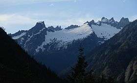 Mount Terror is the pyramid just above and to the right of the down-trending ridgeline in the right center | |
| Highest point | |
| Elevation | 8,151 ft (2,484 m) NGVD 29[1] |
| Prominence | 1,911 ft (582 m) [1] |
| Coordinates | 48°46′27″N 121°17′58″W / 48.7742935°N 121.2995734°WCoordinates: 48°46′27″N 121°17′58″W / 48.7742935°N 121.2995734°W [2] |
| Geography | |
| Location | Whatcom County, Washington, U.S. |
| Parent range | Picket Range, North Cascades |
| Topo map | USGS Mount Challenger |
| Climbing | |
| First ascent | 1932 by William Degenhardt and Herbert Strandberg |
| Easiest route | rock climb or scramble |
Mount Terror is a mountain of the Cascade Range, located in the northwestern corner of Washington state in Whatcom County. The peak is in North Cascades National Park, about 15.7 miles (25.3 km) south of the Canada–US border.
Nearby mountains
Mount Terror is the highest peak of the southern Picket Range. The Pickets, north and south, are considered the most Alpine region of the Cascades. Mount Terror was first climbed in 1932 by William Degenhardt and Herbert Strandberg of the Seattle Mountaineers.[3] Thirty years later Ed Cooper led the first ascent of the more challenging north face.
References
- 1 2 "Mount Terror, Washington". Peakbagger.com.
- ↑ "Mount Terror". Geographic Names Information System. United States Geological Survey.
- ↑ Majors, Harry M. (1975). Exploring Washington. Van Winkle Publishing Co. p. 28. ISBN 978-0-918664-00-6.
External links
- "Southern Pickets topography". Cascade Climbers.
This article is issued from Wikipedia - version of the 10/16/2016. The text is available under the Creative Commons Attribution/Share Alike but additional terms may apply for the media files.