Mount Tahat
| Mount Tahat | |
|---|---|
 | |
| Highest point | |
| Elevation | 2,908 m (9,541 ft) [1] |
| Prominence | 2,328 m (7,638 ft) [1][2] |
| Listing |
Country high point List of mountains in Algeria Ultra |
| Coordinates | 23°17′20″N 5°32′01″E / 23.28889°N 5.53361°ECoordinates: 23°17′20″N 5°32′01″E / 23.28889°N 5.53361°E [2] |
| Geography | |
 Mount Tahat Location in Algeria | |
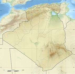
| Location | Algeria |
| Parent range | Ahaggar Mountains |
| Climbing | |
| First ascent | 1931 |
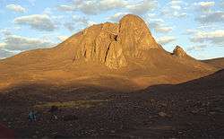
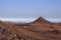
Mount Tahat (Arabic: جبل تاهات) is a mountain peak in the Hoggar Mountains (Ahaggar Mountains) in Algeria. Sitting at 2,908 metres (9,541 ft),[1][2] it is the highest local peak. Mount Tahat's nearest city is Tamanrasset, which is located 56 km to its south.
Mount Tahat is of volcanic origin. It is located in the arid zone of the central Sahara. Growing in a rock environment and plateaus, it rises to 2918 or 3003 meters above sea level according to sources.
The Tuareg inhabit this massif. The city of Tamanrasset is located at the crossroads of the central Sahara, and lies to the southwest of the Hoggar. It was discovered in the mountain's cave paintings, which date from a period between 8000 and 2000 BC. The rock art depicts scenes of cattle breeding and hunting of animals that are today exclusively found in the southern Sahara. This suggests that climate change has occurred since that time.
See also
References
- 1 2 3 "Africa Ultra-Prominences" Peaklist.org. Retrieved 2012-01-14.
- 1 2 3 "Tahat, Algeria". Peakbagger.com. Retrieved 2014-05-15.
External links
| Tell Atlas |
|
|---|---|
| Saharan Atlas |
|
| Saharan massifs | |
| Peaks |
|