Mount Samat National Shrine
| Dambana ng Kagitingan Shrine of Valour | |
|---|---|
| Mount Samat National Shrine | |
 | |
 Philippine Map | |
| Type | Memorial |
| Location | Pilár, Bataan, Philippines |
| Coordinates | 14°36′20.80″N 120°30′32.17″E / 14.6057778°N 120.5089361°ECoordinates: 14°36′20.80″N 120°30′32.17″E / 14.6057778°N 120.5089361°E |
| Area | 73,665 hectares (182,030 acres) |
| Created | 1970 |
| Operated by | Provincial Government of Bataan |
| Open | year round |
| Status |
National Shrine April 14, 1966 |
| Shrine of Valour Memorial Cross | |
 The Bataan Memorial Cross | |
| Location | Pilár, Bataan, Philippines |
|---|---|
| Designer | Lorenzo del Castillo and Napoleon Abueva |
| Type | Historical landmark |
| Material | Steel and reinforced concrete finished with chipped granolithic marble |
| Length | 90 feet (27 m) |
| Width | 18 feet (5.5 m) |
| Height | 92 metres (302 ft) |
| Beginning date | 1966 |
| Completion date | 1970 |
| Opening date | 1970 |
| Dedicated to | Soldiers who fought for freedom in the Battle of Bataan |
Mount Samat National Shrine (Tagalog pronunciation: [samat]) or Dambana ng Kagitingan (Shrine of Valour) is a historical shrine located near the summit of Mount Samat in the town of Pilár, Province of Bataan, in the Republic of the Philippines. The memorial shrine complex was built to honor and remember the gallantry of Filipino and American soldiers who fought during World War II.
Consisting of a Colonnade and the large Memorial Cross, the park was commissioned in 1966 by then-President and dictator Ferdinand Marcos, for the 25th Anniversary of World War II.[1] The white Memorial Cross stands as a remembrance to the soldiers who fought and lost their lives in the Battle of Bataan. The shrine complex also includes a war museum with a wide array of collections from paintings of the Philippine heroes, to armaments used by the Filipino, American and Japanese forces during the battle.
From the colonnade and the cross, there is a panoramic view of Bataan, Corregidor Island and on a clear day, the city of Manila situated about 50 km (31 mi) across Manila Bay.
History
Along with the fortified island of Corregidor, Mount Samat was the site of the most vicious battle against the Japanese Imperial Army in 1942 during the Battle of Bataan. Suffering heavy losses against the Japanese all over Luzon, Filipino and American soldiers retreated to Bataan Peninsula to regroup for a last valiant but futile stand. This retreat to Bataan is part of a United States strategy known as War Plan Orange.
Bataan fell after three months of fighting when 78,000 exhausted, sick and starving men under Major General Edward P. King surrendered to the Japanese on 9 April 1942. It is the single largest surrender of U.S. soldiers in history. Together with the Philippine soldiers, they were then led on the Bataan Death March.
The scene of their last stronghold is Mount Samat, the site of Dambana ng Kagitingan. The shrine was conceived as a fitting memorial to the heroic struggle and sacrifices of the soldiers who fought and died in that historic bastion of freedom.[2]
The memorial shrine complex was started with the laying of the cornerstone by President Marcos on April 14, 1966.[3] Due to lack of funds, construction was unfinished for the 25th anniversary of the Fall of Bataan in 1967.[1] The shrine was completed and inaugurated in 1970, in time for the 25th Anniversary of the end of World War II.
Architectural features
Located in an area approximately 73,665 hectares (182,030 acres), the park consists of the Colonnade and at the mountain's peak, the Memorial Cross. The shrine was designed by Lorenzo del Castillo and landscaped by Dolly Quimbo-Perez.[4]
Colonnade
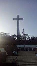
From the parking lot, a wide three series of steps that narrows to the top lead visitors to the flagpole that holds the flag of the Philippines.[5] The last series of steps to the Colonnade level are bordered on two sides by two pedestals topped with bronze urns symbolising the eternal flame.[6]
The Colonnade is a marble-clad structure surrounded by an esplanade, itself surrounded by marble-clad parapets. The outer side is covered with 19 high relief sculptures by National Artist Napoleon Abueva, and alternates depictions of the war with 18 bronze insignia of USAFFE Division units by Talleres de Maximo Vicente, Leonides Valdez, and Angel Sampra and Sons.[4] Each bronze insignia has a flagstaff for the flags of each division.[7]
In the centre of the Colonnade is the altar, behind which are three religious stained glass murals designed by Cenon Rivera and executed by Vetrate D'Arte Giuliani of Rome, Italy.[4] Four large bronze chandeliers hang from the ceiling, while inscribed in marble on the two lateral walls is a narrative of the “Battle of Bataan”.
A footpath that leads to the base of the Memorial Cross begins behind the Colonnade.[8] The 14-flight, zig-zagging path on the mountain slope is paved with bloodstones from Corregidor Island. An alternate road also takes visitors to the base of the Memorial Cross.[2]
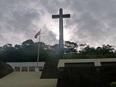
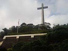
Memorial Cross
(The World's Second Tallest Cross)
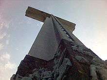
The Memorial Cross is a towering structure at the highest point of Mount Samat, 555 m above sea level. The monument is made of steel and reinforced concrete with a lift and viewing gallery at the Cross's arms. A staircase also leads to the gallery in the wings. The height of the Cross is 92 m from the base; the height of the arms is 74 m from the base, with each arm measuring 30 m (15 on each side). The viewing gallery is 5.5 m by 27.4 m, with a 2.1 m clearance.[2]
The exterior of the Cross is finished with chipped granolithic marble. The base until the 11 m level is capped with sculptural slabs and relief[9] titled Nabiag Na Bato also by Abueva, depicting important historical figures and events like the execution of Jose Rizal,[10] Lapu-Lapu[11] and Antonio Luna.[12]
Location
The Shrine complex is part of Barangay Diwa in Pilár, Bataan. From Manila, the complex can be reached via the North Luzon Expressway (Balintawak Cloverleaf) and the SCTEX exit in Mabalacat, Pampanga which leads to the Subic-Clark-Tarlac Expressway. Follow the signs to Subic, and exit at Dinalupihan then turn right at the Roman Highway. Upon reaching the Mt. Samat junction after about 24 km, turn right. After about 4.5 km towards Mt. Samat, to the left is a 6.5 km uphill road to the Shrine.[13]
Gallery
 Shrine of Valour
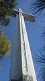 The War Memorial Cross
References
- 1 2 Yu Jose, Lydia N. (2008). "The Past, Love, Money and Much More: Philippine-Japan Relations Since the End of Second World War", p.23. Ateneo de Manila University.
- 1 2 3 Government of Province of Bataan (2006)."Dambana ng Kagitingan". Bataan...A Raging Peninsula. Retrieved on 2011-03-27.
- ↑ "Mt. Samat National Shrine". National Registry of Historic Sites and Structures in the Philippines. Retrieved on 2012-06-08.
- 1 2 3 "Memorials in the Philippines". Filipinos World War II US Military Service. Retrieved on 2011-03-27.
- ↑ rhilton4u (2009-03-09). "Memorial Steps: Mt. Samat Shrine". Flickr. Retrieved on 2011-03-27.
- ↑ rhilton4u (2009-03-09). "Base Memorial: Mt. Samat Shrine". Flickr. Retrieved on 2011-03-27.
- ↑ rhilton4u (2009-03-09). "Mt. Samat Shrine of Valor". Flickr. Retrieved on 2011-03-27.
- ↑ rhilton4u (2009-03-09)."Mt. Samat Shrine of Valor". Flickr. Retrieved on 2011-03-27.
- ↑ "Mount Samat Shrine". Flickr. Retrieved on 2011-03-15.
- ↑ pianoforte (2010-03-15). "Mt. Samat Cross". Flickr. Retrieved on 2011-03-27.
- ↑ pianoforte (2010-03-13). "Mt. Samat Cross". Flickr. Retrieved on 2011-03-27.
- ↑ pianoforte (2010-03-15). "Mt. Samat Cross". Flickr. Retrieved on 2011-03-27.
- ↑ "Mount Samat Shrine". Waypoints. Retrieved on 2011-03-21.
External links
| Wikimedia Commons has media related to Mount Samat National Shrine. |
| Government cultural agencies | ||
|---|---|---|
| Categories of cultural properties |
| |
| Related | ||