Mount Saint John
For the New Zealand volcanic peak, see Mount Saint John, New Zealand.
"Mount St John" redirects here. For the suburb in Townsville, Australia, see Mount St John, Queensland. For the Australian World War II defences, see Mount St John Anti-Aircraft Battery.
| Mount Saint John | |
|---|---|
 Mount Saint John | |
| Highest point | |
| Elevation | 11,435 ft (3,485 m) NAVD 88[1] |
| Prominence | 1,350 ft (410 m) [1] |
| Coordinates | 43°46′55″N 110°46′24″W / 43.78194°N 110.77333°WCoordinates: 43°46′55″N 110°46′24″W / 43.78194°N 110.77333°W [2] |
| Geography | |
| Location | Grand Teton National Park, Teton County, Wyoming, U.S. |
| Parent range | Teton Range |
| Topo map | USGS Mount Moran |
| Climbing | |
| First ascent | Fryxell/Smith 1929 |
| Easiest route | Scramble |
Mount Saint John, height 11,430 feet (3,480 m), is located in the Teton Range, Grand Teton National Park, Wyoming, northwest of Jenny Lake.[3] The mountain towers above the northwest shore of Jenny Lake, and along with Symmetry Spire and Rockchuck Peak, form a massif which looms to the north above Cascade Canyon. The scenic Lake of the Crags, a cirque lake or tarn, is located immediately south of the summit and is accessed by way of Hanging Canyon.
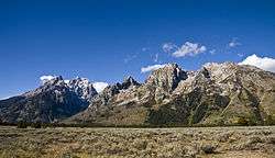
Teton Range left to right with the Cathedral Group, Cascade Canyon, Symmetry Spire, Mount Saint John and Rockchuck Peak
References
- 1 2 "Mount Saint John, Wyoming". Peakbagger.com. Retrieved 2011-05-28.
- ↑ "Mount Saint John". Geographic Names Information System. United States Geological Survey. Retrieved 2011-05-28.
- ↑ Mount Moran, WY (Map). TopoQwest (United States Geological Survey Maps). Retrieved 2011-05-28.
This article is issued from Wikipedia - version of the 1/17/2016. The text is available under the Creative Commons Attribution/Share Alike but additional terms may apply for the media files.