Mount Pico de Loro
| Mount Pico de Loro | |
|---|---|
| Mount Palay-Palay | |
 | |
| Highest point | |
| Coordinates | 14°12′51″N 120°38′47″E / 14.2142864°N 120.6464909°ECoordinates: 14°12′51″N 120°38′47″E / 14.2142864°N 120.6464909°E |
| Geography | |
.svg.png) Mount Pico de Loro Location within the Philippines | |
| Location | Mounts Palay-Palay–Mataas-na-Gulod Protected Landscape, Luzon |
| Country | Philippines |
| Region | CALABARZON |
| Provinces | |
| Municipalities | |
| Geology | |
| Mountain type | Stratovolcano |
| Volcanic arc/belt | Bataan Arc |
| Last eruption | Unknown |
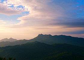
Mount Pico de Loro, also known as Mount Palay-Palay, is a dormant volcano in Cavite province on the island of Luzon, Philippines. The mountain is one of the ancient volcanic features of Bataan Arc.[1]
History
Pico de Loro was first named by Spanish sea-farers which means "Parrot's Beak" as its pointed summit resembles the shape of a parrot's beak from afar and it is commonly used as a signal by sea-farers to turn east to get to Manila Bay.[2]
Governance
Under the Proclamation No. 1315 s. 2007 [3] of the Philippine government, the Mounts Palay-Palay–Mataas-na-Gulod Protected Landscape is placed under the protection and jurisdiction of the Department of Environment and Natural Resources.
Hiking activity
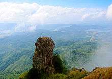
At the summit of Mt. Pico de Loro is a monolith. Also known as the Parrot's beak.
See also
References
- ↑ Tectonophysics. Amsterdam: Elsevier Science Publishers. 1990. p. 266.
- ↑ "Pico De Loro (664+)". Pinoy Mountaineer. Retrieved 17 January 2015.
- ↑ "Proclamation No. 1315, s. 2007". Official Gazette of the Republic of the Philippines. Retrieved 17 January 2015.
| Wikimedia Commons has media related to Mount Pico De Loro. |
This article is issued from Wikipedia - version of the 7/26/2016. The text is available under the Creative Commons Attribution/Share Alike but additional terms may apply for the media files.