Mount Natib
| Mount Natib | |
|---|---|
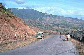 Mt. Natib as viewed from WSW | |
| Highest point | |
| Elevation | 1,253 m (4,111 ft) [1] |
| Listing | Potentially active volcano |
| Coordinates | 14°43′N 120°24′E / 14.72°N 120.40°ECoordinates: 14°43′N 120°24′E / 14.72°N 120.40°E [1] |
| Geography | |
.svg.png) Mount Natib Location within the Philippines | |
| Location | Bataan Peninsula, Luzon |
| Country | Philippines |
| Region | Central Luzon |
| Province | Bataan |
| Parent range | Zambales Mountains |
| Geology | |
| Age of rock | Pliocene to Pleistocene[1] |
| Mountain type | Stratovolcano-Caldera |
| Volcanic arc/belt | Western Bataan Lineament |
| Last eruption | Unknown, est. upper Pleistocene to Holocene |
Mount Natib /nɑːˈtiːb/ is a dormant volcano and caldera complex in the province of Bataan on western Luzon Island of the Philippines. The volcano complex occupies the northern portion of the Bataan Peninsula. The mountain and adjacent surrounding is a protected area first declared as the Bataan National Park in 1945.[2][3]
Physical features
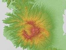
Mount Natib is a stratovolcano type of volcano topped by a 6-by-7-kilometre (3.7 by 4.3 mi) acorn-shaped Natib Caldera that is open to the northwest. East of its caldera is the smaller 2-kilometre (1.2 mi) wide Pasukulan Caldera.[3] The highest peak of Mount Natib has an elevation of 1,253 metres (4,111 ft) asl and is at the point of convergence of the two calderas. The caldera complex has an overall base diameter of 26 kilometres (16 mi).[4]
Volcanic activity
There are no historical eruptions within the Natib caldera complex. Studies in 1991 (Panum and Rayem) indicate that the last eruptive activity was probably Holocene to upper Pleistocene.[1] An earlier study in 1971 (Ebasco Services) dated the eruptive products between 69,000 +/- 27,000 years old.[1] A recent study by Dr. Kevin Rodolfo of the Department of Earth and Environmental Sciences at the University of Illinois at Chicago, had Mount Natib's latest eruption between 11,000 and 18,000 years ago after studying a prehistoric pyroclastic flow from the volcano that entered Subic Bay in Zambales province.[5] Current activity on Natib is through five thermal areas. The hot springs in the Natib caldera are Asin,[1] Mamot, Tigulangin, Uyong and Paipit springs. The hot springs have temperatures ranging from 30-56 °C, with low flows, and a neutral to slightly alkaline water discharge.[4]
The Philippine Institute of Volcanology and Seismology (PHIVOLCS) lists Mount Natib as a potentially active volcano.[4]
Geology
The rocks found on Natib are predominantly biotite, hornblende, andesite, trending to dacite flows and dacitic tuffs, which are similar to Mount Mariveles, the southern half of the Bataan Peninsula.[4][6]
Natib is part of the Western Bataan Lineament volcanic belt which includes the active Mount Pinatubo.[7]
See also
- List of active volcanoes in the Philippines
- List of potentially active volcanoes in the Philippines
- List of inactive volcanoes in the Philippines
- Pacific Ring of Fire
References
- 1 2 3 4 5 6 "Natib". Global Volcanism Program. Smithsonian Institution. Retrieved 2008-12-02.
- ↑ "Protected Areas in Region 3". Protected Areas and Wildlife Bureau of the Philippines. Retrieved on 2012-02-21.
- 1 2 Mt. Natib". Bataan...Raging Peninsula. Retrieved on 2012-02-21.
- 1 2 3 4 "Natib". Philippine Institute of Volcanology and Seismology. Retrieved on 2012-02-21.
- ↑ Cherry (2012-02-03). "Preserve Mt. Natib of Bataan". MyBataan.com. Retrieved on 2012-02-21.
- ↑ "Mariveles". Philippine Institute of Volcanology and Seismology. Retrieved on 2012-02-21.
- ↑ "Pinatubo Volcano". Philippine Institute of Volcanology and Seismology. Retrieved on 2012-02-21.
External links
- Philippine Institute of Volcanology and Seismology (PHIVOLCS), Natib page
- Smithsonian Institution's Global Volcanism Program, Natib page