Mount Merritt
| Mount Merritt | |
|---|---|
 Mount Merritt from Glenns Lake | |
| Highest point | |
| Elevation | 10,004 ft (3,049 m) [1] |
| Prominence | 2,904 ft (885 m) [1] |
| Coordinates | 48°52′13″N 113°47′11″W / 48.87028°N 113.78639°WCoordinates: 48°52′13″N 113°47′11″W / 48.87028°N 113.78639°W [2] |
| Geography | |
 Mount Merritt | |
| Parent range | Lewis Range |
| Topo map | USGS Ahern Pass, MT |
| Climbing | |
| First ascent | 1924 (Norman Clyde)[1] |
Mount Merritt (10,004 feet (3,049 m)) is located in the Lewis Range, Glacier National Park in the U.S. state of Montana.[3] The peak is one of six in Glacier National Park that rise over 10,000 feet (3,048 m).[1] Located in the northeastern part of the park, Mount Merritt rises dramatically a vertical mile above nearby rivers. The approach to this remote peak involves a one way hike of 13 miles (21 km) to the summit base. Near the summit, the Old Sun Glacier hangs along the east ridge.[4] The summit is named for General Wesley Merritt in 1891 by members of Troop C, 1st Cavalry who were visiting the region while stationed at Fort Assiniboine.[5]
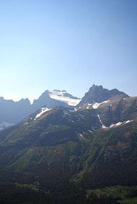
Mount Merritt as viewed from the Elizabeth Lake Trail. The large snowfield flanking the mountain's east face is Old Sun Glacier, and the sharp prominence to the right is known as Natoas Peak.
See also
References
- 1 2 3 4 "Mount Merritt, Montana". Peakbagger.com. Retrieved October 5, 2014.
- ↑ "Mount Merritt". Geographic Names Information System. United States Geological Survey. Retrieved October 5, 2014.
- ↑ Ahern Pass, MT (Map). TopoQwest (United States Geological Survey Maps). Retrieved October 5, 2014.
- ↑ "Mount Merritt". Summitpost. Retrieved October 5, 2014.
- ↑ Holterman, Jack (2006). Place Names of Glacier National Park. Helena, MT: Riverbend Publishing. p. 141. ISBN 1-931832-68-4.
This article is issued from Wikipedia - version of the 11/25/2016. The text is available under the Creative Commons Attribution/Share Alike but additional terms may apply for the media files.