Mount Mageik
| Mount Mageik | |
|---|---|
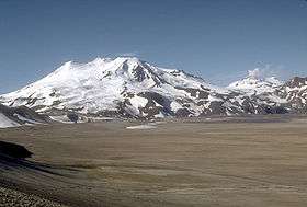 Mount Mageik (left) and Mount Martin (right) | |
| Highest point | |
| Elevation | 7,101 ft (2,164 m) [1] |
| Listing | List of mountains of Alaska |
| Coordinates | 58°11′44″N 155°15′13″W / 58.19556°N 155.25361°WCoordinates: 58°11′44″N 155°15′13″W / 58.19556°N 155.25361°W [2] |
| Geography | |
| Location | Katmai National Park and Preserve, Alaska, U.S. |
| Parent range | Aleutian Range |
| Topo map | USGS Mount Katmai A-4 |
| Geology | |
| Age of rock | Pleistocene to Holocene |
| Mountain type | Stratovolcano |
| Volcanic arc | Aleutian Arc |
| Last eruption | 500 BCE ± 50 years[1] |
Mount Mageik /məˈɡiːk/ is a stratovolcano on the Alaska Peninsula. It has no confirmed historical eruptions (one in 1946 is now deemed questionable), but its youngest eruptive products are apparently Holocene in age (8750 to 500 BCE).[1] A young crater lies on the northeast flank of the central summit cone, and is the site of vigorous superheated fumarolic activity with prominent sulfur deposits. The volcanic cones are composed of andesite, basaltic andesite and dacite.[1]
The volcano is mantled in ash from the 1912 eruption of Novarupta and from the 1953 eruption of nearby Trident Volcano.

Map showing volcanoes of Alaska Peninsula.
See also
References
- 1 2 3 4 "Mageik". Global Volcanism Program. Smithsonian Institution. Retrieved 2015-01-18.
- ↑ "Mount Mageik". Geographic Names Information System. United States Geological Survey. Retrieved 2015-01-18.
External links
- Volcanoes of the Alaska Peninsula and Aleutian Islands-Selected Photographs
- Alaska Volcano Observatory
This article is issued from Wikipedia - version of the 1/2/2016. The text is available under the Creative Commons Attribution/Share Alike but additional terms may apply for the media files.