Mount Hope, New York
| Mount Hope, New York | |
|---|---|
| Town | |
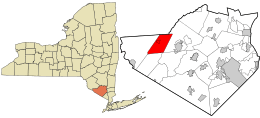 Location in Orange County and the state of New York. | |
 Mount Hope, New York Location within the state of New York | |
| Coordinates: 41°27′58″N 74°31′37″W / 41.46611°N 74.52694°WCoordinates: 41°27′58″N 74°31′37″W / 41.46611°N 74.52694°W | |
| Country | United States |
| State | New York |
| County | Orange |
| Area | |
| • Total | 25.5 sq mi (66.0 km2) |
| • Land | 25.2 sq mi (65.2 km2) |
| • Water | 0.3 sq mi (0.8 km2) |
| Elevation | 738 ft (225 m) |
| Population (2010) | |
| • Total | 7,018 |
| Time zone | Eastern (EST) (UTC-5) |
| • Summer (DST) | EDT (UTC-4) |
| FIPS code | 36-48857 |
| GNIS feature ID | 0979241 |
Mount Hope is a town in Orange County, New York, United States. The population was 7,018 at the 2010 census.
The Town of Mount Hope is in the northwestern part of the county, west of Middletown. The north town line is the border of Sullivan County.
History
The first known settler of European descent arrived around 1733.
The Town of Mount Hope was created from the Towns of Deerpark and Wallkill in 1825.
Geography
According to the United States Census Bureau, the town has a total area of 25.5 square miles (66 km2), of which, 25.2 square miles (65 km2) of it is land and 0.3 square miles (0.78 km2) of it (1.22%) is water.
The Shawangunk Mountains lie on the west town line, and Shawangunk Creek flows through Mount Hope.
Transportation
New York State Route 211 is an east-west highway in the town.
Metro-North Railroad's Port Jervis Line has a station at nearby Otisville.
Demographics
| Historical population | |||
|---|---|---|---|
| Census | Pop. | %± | |
| 1830 | 1,535 | — | |
| 1840 | 1,565 | 2.0% | |
| 1850 | 1,512 | −3.4% | |
| 1860 | 1,575 | 4.2% | |
| 1870 | 1,842 | 17.0% | |
| 1880 | 1,549 | −15.9% | |
| 1890 | 1,437 | −7.2% | |
| 1900 | 1,236 | −14.0% | |
| 1910 | 1,786 | 44.5% | |
| 1920 | 1,708 | −4.4% | |
| 1930 | 1,847 | 8.1% | |
| 1940 | 1,817 | −1.6% | |
| 1950 | 2,298 | 26.5% | |
| 1960 | 2,291 | −0.3% | |
| 1970 | 2,966 | 29.5% | |
| 1980 | 4,398 | 48.3% | |
| 1990 | 5,971 | 35.8% | |
| 2000 | 6,639 | 11.2% | |
| 2010 | 7,018 | 5.7% | |
| Est. 2014 | 7,079 | [1] | 0.9% |
As of the census[3] of 2000, there were 6,639 people, 1,582 households, and 1,218 families residing in the town. The population density was 263.5 people per square mile (101.8/km²). There were 1,714 housing units at an average density of 68.0 per square mile (26.3/km²). The racial makeup of the town was 78.63% White, 16.51% African American, 0.27% Native American, 1.48% Asian, 0.03% Pacific Islander, 1.84% from other races, and 1.25% from two or more races. Hispanic or Latino of any race were 14.61% of the population.
There were 1,582 households out of which 40.5% had children under the age of 18 living with them, 63.3% were married couples living together, 9.3% had a female householder with no husband present, and 23.0% were non-families. 18.6% of all households were made up of individuals and 8.0% had someone living alone who was 65 years of age or older. The average household size was 2.93 and the average family size was 3.34.
In the town the population was spread out with 20.6% under the age of 18, 7.3% from 18 to 24, 42.0% from 25 to 44, 23.1% from 45 to 64, and 7.0% who were 65 years of age or older. The median age was 36 years. For every 100 females there were 186.2 males. For every 100 females age 18 and over, there were 216.1 males.
The median income for a household in the town was $56,948, and the median income for a family was $65,183. Males had a median income of $36,765 versus $30,208 for females. The per capita income for the town was $17,562. About 3.5% of families and 5.2% of the population were below the poverty line, including 7.0% of those under age 18 and 3.3% of those age 65 or over.
Communities and locations in Mount Hope
- FCI Otisville – A federal prison near Otisville village.
- Finchville – A hamlet in the southwest part of Mount Hope on County Road 35, named after the earliest known settler in the town.
- Guymard – A hamlet in the southwest part of the town on the town line.
- Mount Hope – The hamlet of Mount Hope on County Road 11, south of Otisville.
- Otisville – The Village of Otisville is located near the west town line on NY-211.
- Otisville Correctional Facility – A NY medium security prison near Otisville village.
- Shawangunk Lake – A lake at the east town line.
References
- ↑ "Annual Estimates of the Resident Population for Incorporated Places: April 1, 2010 to July 1, 2014". Retrieved June 4, 2015.
- ↑ "Census of Population and Housing". Census.gov. Retrieved June 4, 2015.
- ↑ "American FactFinder". United States Census Bureau. Retrieved 2008-01-31.
Municipalities and communities of Orange County, New York, United States | ||
|---|---|---|
| Cities | 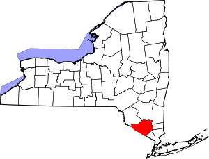 | |
| Towns | ||
| Villages | ||
| CDPs | ||
| Other hamlets | ||