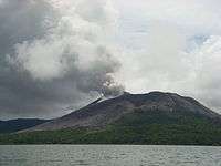
Mount Gharat
| Mount Gharat (Mount Garet) | |
|---|---|
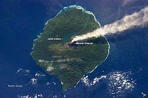
 Mount Gharat and Lake Letas. | |
| Highest point | |
| Elevation | 797 m (2,615 ft) |
| Prominence | 797 m (2,615 ft) |
| Coordinates | 14°16′S 167°30′E / 14.267°S 167.500°ECoordinates: 14°16′S 167°30′E / 14.267°S 167.500°E |
| Geography | |
| Location | Gaua, Banks Islands, Vanuatu |
| Geology | |
| Mountain type | Stratovolcano |
| Last eruption | 2011 |
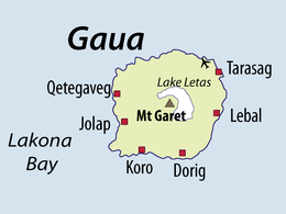
Mount Gharat or Mount Garet (797 m) is the highest peak on the volcanic island of Gaua of the Banks Islands in northern Vanuatu. The peak is located at the centre of the island, is volcanically active and is surrounded by Lake Letas on all sides except southwest.
| Mount Gharat on Gaua island | ||||||
|---|---|---|---|---|---|---|
|
References
This article is issued from Wikipedia - version of the 10/31/2016. The text is available under the Creative Commons Attribution/Share Alike but additional terms may apply for the media files.