Mount Anderson (Antarctica)
| Mount Anderson | |
|---|---|
| Highest point | |
| Elevation | 4,254 m (13,957 ft) [1] |
| Prominence | 1,504 m (4,934 ft) [1] |
| Coordinates | 78°09′00″S 86°13′01″W / 78.15°S 86.217°WCoordinates: 78°09′00″S 86°13′01″W / 78.15°S 86.217°W [2] |
| Geography | |
| Location |
|
| Parent range |
Sentinel Range, (Ellsworth Mountains) |
| Climbing | |
| First ascent | January 7th 2007 - Jed Brown (US) & Damien Gildea (AUS) |
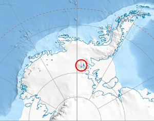
Location of Sentinel Range in Western Antarctica.
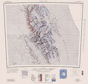
Sentinel Range map.
Mount Anderson is a high mountain in the northern part of the Sentinel Range in Ellsworth Mountains, Antarctica.[3] Probuda Ridge is trending northeast of the peak, and Embree Glacier and Ellen Glacier's tributary Fonfon Glacier drain its northeastern and eastern slopes respectively. It is part of the same massif as Mount Bentley and Mount Sisu.
The mountain was discovered by the Marie Byrd Land Traverse Party, 1957–58, under C.R. Bentley, and named for Vernon H. Anderson, glaciologist at Byrd Station, 1957, a member of the party.[2]
Maps
- Vinson Massif. Scale 1:250 000 topographic map. Reston, Virginia: US Geological Survey, 1988.
Notes
- 1 2 "Mount Anderson, Antarctica". Peakbagger.com. Retrieved 2014-08-17.
- 1 2 "Mount Anderson". Geographic Names Information System. United States Geological Survey. Retrieved 2014-08-17.
- ↑ Gildea, Damien (2001). "Mountaineering in Antarctica". Archived from the original on 2006-08-28. Retrieved 2014-08-17.
References
This article is issued from Wikipedia - version of the 11/12/2015. The text is available under the Creative Commons Attribution/Share Alike but additional terms may apply for the media files.