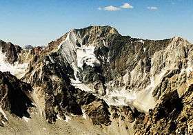
Mount Adelung
| Adelung | |
|---|---|
| гора Аделунга, Adelunga Toghi | |
 | |
| Highest point | |
| Elevation | 4,301 m (14,111 ft) |
| Coordinates | 42°07′N 70°58′E / 42.117°N 70.967°ECoordinates: 42°07′N 70°58′E / 42.117°N 70.967°E |
| Geography | |
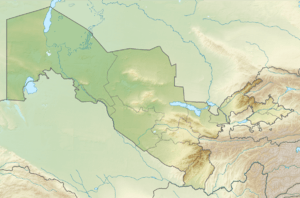 Adelung Location in Uzbekistan | |
| Location | Tashkent, Uzbekistan |
| Parent range | Pskem Mountains |
Mount Adelung (Russian: Гора Аделунга) is the highest peak in Pskem Range (Russian: Пскемский хребет) in the extreme north-east of the Tashkent Province, Uzbekistan.[1] Mount Adelung is the highest point of Tashkent Province at 4,301 meters, just 2 meters higher than the nearby Mount Beshtor, located a little further to the south-west in the same range, and it is often erroneously identified in various web sources as the "highest point in Uzbekistan". In fact, this honor goes to the Khazret Sultan, a peak with an altitude of 4,643 m in Surkhandarya Province, in the Uzbek part of the Gissar Range, on the border with Tajikistan, which was formerly known as Peak of the 22nd Congress of the Communist Party.[2][3]
Some web sources use the name Adelunga Toghi, where Adelunga corresponds to the Russian possessive form of Adelung and Toghi presumably stands for mountain in the Uzbek language (tog’ in Latin script, тоғ in Cyrillic script). It is not known at this stage of writing which Adelung the mountain is named after.
References
- ↑ Physical map of Tashkent Province, Uzgeodezkadastr, Tashkent, 2002 (low resolution)
- ↑ Atlas of the Soviet Central Asian Republics, Geodesy and Cartography Authority, Moscow, 1988, in Russian.
- ↑ Administrative map of the Republic of Uzbekistan, State Committee of Land Resources, Geodesy, Cartography, and State Cadastre, Tashkent, 2007.