Haugh of Urr
Coordinates: 54°58′41″N 3°52′05″W / 54.978°N 3.868°W
Haugh of Urr (/ˌhɒx əv ˈɜːr/), is a village in Dumfries and Galloway, south-west Scotland. It is approximately 4 miles (6.4 km) NNW of Dalbeattie, 3 miles (4.8 km) NE of Castle Douglas, 12½ miles west of Dumfries and 12½ miles east of Kirkcudbright.
Description
The village is situated beside the River Urr. Scots haugh, from Old English halh, healh 'corner, nook' means river-meadow or a level piece of ground beside a stream.[1] 'Urr' is from Cumbric or 'a border, boundary, limit'.[2]
It has one public house, the Laurie Arms which incorporates a part-time Post Office, one Church (Church of Scotland), a Village Hall, a Scout hut, and a small village green. The village no longer has any shops. It used to have two shops, one of which included a petrol filling station, while the other included a full-time post office, which reduced to part-time in later years. The last shop closed in 2009. Hardgate is a nearby hamlet up the hill and the boundaries are indistinct. Agriculture and tourism are the mainstays of the local economy. The village is known to locals as "The Haugh". The Australian suburb of Urrbrae was named after the village.
River Urr

The River Urr is noted for salmon fishing. The river originates at Glenlair and flows for thirty miles from Loch Urr to its outflow into the Solway Firth at Kippford near Dalbeattie.
Motte of Urr
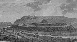
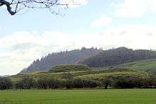
The Motte of Urr, is the site of a motte-and-bailey castle. Today this medieval earthwork near the Haugh of Urr is said to be the most extensive bailey earthwork in Scotland. It lies beside the River Urr to the north west of Dalbeattie. It dates from the 12th century, and covers an area of about 2 ha (5 acres). In the present day, there are no excavations or walls. It is associated with Buittle Castle, a courtyard castle dating to about 1230, which was destroyed early in the 14th century and belonged to Devorgilla and her husband John I de Balliol (founder of Balliol College, at Oxford University). Together they bore the future king John of Scotland.
List of listed buildings
List of listed buildings in Urr, Dumfries and Galloway
References
- ↑ "Dictionary of the Scotland Language: s.v. Haugh". www.dsl.ac.uk. Retrieved 2015-03-24.
- ↑ James, Alan G. (2014). The Brittonic Language in the Old North: A Guide to the Place-Name Evidence (PDF). Volume 2: Guide to the Elements. p. 299. Archived from the original (PDF) on 2014-09-11.
External links
| Wikimedia Commons has media related to Urr. |
- Overview of the village http://www.scottish-places.info/towns/townfirst3245.html
- Urr parish church http://www.dlbteparishch.f9.co.uk/page15.html
- Parish information http://www.genuki.org.uk/big/sct/KKD/Urr/
- Vale of Urr http://www.glenlair.org.uk/vale_of_the_urr.asp
- Unpublished records for the parish of Urr in Kirkcudbrighshire http://donjaggi.net/galloway/index.html
- River Urr http://www.glenlair.org.uk/river_urr.asp
- Motte of Urr http://www.scottish-places.info/features/featurefirst8406.html
- Motte of Urr http://thereformation.info/motte.htm
- Buittle Castle http://www.rcahms.gov.uk/pls/portal/newcanmore.details_gis?inumlink=65002
 The village, 2006
 Urr Parish Church, 2006