Mosby Creek (Oregon)
| Mosby Creek | |
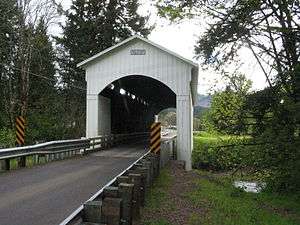 Mosby Creek Bridge | |
| Name origin: David Mosby, pioneer settler | |
| Country | United States |
|---|---|
| State | Oregon |
| County | Lane |
| Source | confluence of West and East forks |
| - location | near the Calapooia Divide |
| - elevation | 1,508 ft (460 m) [1] |
| - coordinates | 43°33′12″N 122°51′02″W / 43.55333°N 122.85056°W [2] |
| Mouth | Row River |
| - location | near Cottage Grove |
| - elevation | 669 ft (204 m) [2] |
| - coordinates | 43°46′47″N 123°00′48″W / 43.77972°N 123.01333°WCoordinates: 43°46′47″N 123°00′48″W / 43.77972°N 123.01333°W [2] |
| Length | 21 mi (34 km) [3] |
 Location of the mouth of Mosby Creek in Oregon | |
Mosby Creek is a 21-mile (34 km) tributary of the Row River in Lane County, in the U.S. state of Oregon. It begins at the confluence of the east and west forks of the creek near the Calapooia Divide and the border with Douglas County. From its source it flows generally north-northwest to meet the river slightly east of Cottage Grove and about 4 miles (6 km) from the larger stream's confluence with the Coast Fork Willamette River.[3]
Mosby Creek was named for David Mosby, an early settler.[4] He lived near the mouth of the stream, once known as Brumbaugh Creek.[5]
Mosby Creek Covered Bridge, 90 feet (27 m) long, carries Layng Road over the creek east of Cottage Grove. Built in 1920, it is the oldest covered bridge in Lane County.[6]
Further upstream near Walden, the Stewart Covered Bridge carries Garoutte Road over the creek. Built in 1930 and restored in 1996, this 60-foot (18 m) span is used only for pedestrian and bicycle traffic.[7]
Tributaries
Mosby Creek's east and west forks meet to form the main stem. Named tributaries from source to mouth include Cove, Tom, Miles, Tones, Lilly, Brownie, and Shea creeks. Then come Gray, Norwegian, Dahl, Little Dry, Dry, Bark Shanty, and Stell creeks, followed by Allen, Cedar, Clearing, Cow, Palmer, Rock, and Lewis creeks. Below that are Simpson, Blue, Short, Fall, Kennedy, Smith, Perkins, Kizer, and Champion creeks.[3]
See also
References
- ↑ Source elevation derived from Google Earth search using GNIS source coordinates.
- 1 2 3 "Mosby Creek". Geographic Names Information System. United States Geological Survey (USGS). November 28, 1980. Retrieved November 13, 2015.
- 1 2 3 "United States Topographic Map". United States Geological Survey. Retrieved November 13, 2015 – via ACME Mapper. The map includes mile markers along the creek.
- ↑ "Indians, Surveyors, Incidents Gave Names to Streams, Lakes and Mountains". Eugene Register-Guard. January 4, 1942. p. 5. Retrieved April 23, 2015.
- ↑ McArthur, Lewis A.; McArthur, Lewis L. (2003) [1928]. Oregon Geographic Names (7th ed.). Portland, Oregon: Oregon Historical Society Press. pp. 660–61. ISBN 0-87595-277-1.
- ↑ "Mosby Creek Covered Bridge". Lane County. Retrieved April 23, 2015.
- ↑ "Lane County Covered Bridge Coins". Lane County, Oregon. 2012. Retrieved January 9, 2016.