Morro Rock
| Morro Rock | |
|---|---|
 Morro Rock looking west. | |
| Highest point | |
| Elevation | 581 ft (177 m) NAVD 88[1] |
| Coordinates | 35°22′10″N 120°52′03″W / 35.369430653°N 120.867550139°WCoordinates: 35°22′10″N 120°52′03″W / 35.369430653°N 120.867550139°W [1] |
| Geography | |
 Morro Rock  Morro Rock | |
| Parent range | Santa Lucia Range |
| Topo map | USGS Morro Bay South |
| Geology | |
| Age of rock | c. 23 million years[2] |
| Mountain type | Volcanic plug |
| Volcanic arc/belt | Nine Sisters |
| Designated | January 1, 1968 |
| Reference no. | 821[3] |


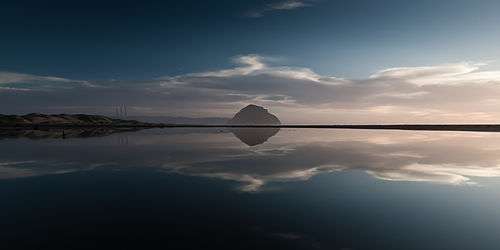
Morro Rock is a 581-foot (177 m)[1] volcanic plug located just offshore from Morro Bay, California, at the entrance to Morro Bay Harbor. A causeway connects it with the shore, effectively making it a tied island. The area surrounding the base of Morro Rock can be visited. The rock is protected as the Morro Rock State Preserve. Climbing on the rock or disturbing the bird life is forbidden by law.[4]
History
Geologically, Morro Rock, located in San Luis Obispo County, in the town of Morro Bay, California, is one of 13 volcanic, intrusive units that form volcanic plugs (remnant volcanic necks of volcanoes), lava domes, and sheetlike intrusions from Morro Rock southeast 29 km or 18 mi to Islay Hill. The plugs form the distinctive peaks along U.S. Highway 101 just south of San Luis Obispo and south of State Highway 1 from San Luis Obispo to Morro Bay. The rock is composed of dacite, [5] a felsic extrusive rock, intermediate in composition between andesite and rhyolite, and is a member of the igneous family. Its lithology and composition is a groundmass of plagioclase with amphibole (hornblende), biotite, pyroxene (augite), quartz, and glass; phenocrysts of plagioclase, amphibole and often quartz. Its silica (SiO2) content can range from 63%-69%. The dacite volcanic plugs, lava domes, intrusive sheets, and felsitic rhyolite-dacite between Morro Rock and Islay Hill are part of the Oligocene (27-23 Ma) Mono Rock-Islay Hill Complex. The complex lies east of the San Gregorio-San Simeon-Hosgri fault (SG-SS-H fault). This complex is one of three probable sources of the volcanic clasts within the sandstone and conglomerate of the Miguelito and Edna members of the Pismo Formation in the Point Sur area 145–160 km (90-100 mi) to the north and west of the SG-SS-H fault. Based on paleomagnetic signatures, the 27-23 Ma Morro Rock-Islay Hill Complex was rotated 40'-50',perhaps during late Miocene or early Pliocene time.[6]
The rock was quarried on and off from 1889 to 1969, and provided material for the breakwater of Morro Bay and Port San Luis Harbor. In 1966, a state law was adopted that transferred title to the State of California. In February 1968, the San Luis Obispo County Historical Society and the City of Morro Bay succeeded in having Morro Rock declared California Historical Landmark number 821.[3][7]
Morro Rock was probably seen by Spanish maritime explorers as early as 1542 under Juan Rodriguez Cabrillo, but its current name was given during the first European land exploration of Alta California. The Spanish Portolà expedition came down Los Osos Valley and camped near today's Morro Bay on September 8, 1769. Franciscan missionary and expedition member Juan Crespi noted in his diary that "we saw a great rock in the form of a round morro".[8][9] Since then, it has become an important landmark to sailors and travelers. Note that the similar Spanish descriptive word "moro" translates to "Moor" rather than a color, and furthermore the word "morro" translates to "nose."
The Salinan and Chumash tribes considered Morro Rock to be a sacred site. The Chumash had an important nearby prehistoric settlement at least as early as the Millingstone Horizon (6500-2000 B.C.E.), and the village was near the mouth of Morro Creek. The right of the Chumash people to climb Morro Rock for their annual solstice ceremony is now well established, but it is illegal for the general public to climb it.[10]
Despite protests by the Chumash, Salinan tribe members also have exemption to legally climb Morro Rock for an annual ceremony celebrating the time in legend when hawk and raven destroyed the two-headed serpent-monster Taliyekatapelta, as he wrapped his body around the base of the rock.[7]
The Rock, as locals call it, was previously surrounded by water. However, the northern channel's harbor was made from its sediment.
Morro Rock is the best known of the Nine Sisters of San Luis Obispo County, a series of ancient volcanic plugs that line the Los Osos Valley between the cities of Morro Bay and San Luis Obispo. It was one of many local landmarks to be mentioned in "Weird Al" Yankovic's 1978 song "Take Me Down."
Flora and fauna
Several types of birds nest on Morro Rock, including three cormorant species and two gull species.[11] It presently serves as a reserve for peregrine falcons, which are locally endangered and cause most of the laws that prohibit intervention with avian life.
Sea lions and sea otters can be seen regularly in the water around the rock.[12] Seals, however, are much more common in the nearby Morro Bay State Park, where they breed.
Other fauna include a wide selection of tide pool animals, like hermit crabs, small fish, starfish, sea cucumbers, mussels, bivalve mollusks, coral, and more.
On land few flora can survive the harsh, dry environment on the rock, but in the surrounding bay, kelp, sea grass, kelp forest plants, and tide pool plants can survive, and a few common grasses, mosses, lichens and weeds from the mainland take root on the rock itself.
Marine protected areas
Morro Bay State Marine Recreational Management Area and Morro Bay State Marine Reserve are marine protected areas offshore from Morro Bay. Like underwater parks, these marine protected areas help conserve ocean wildlife and marine ecosystems.
Panorama
References
- 1 2 3 "Morro 2 reset". NGS data sheet. U.S. National Geodetic Survey. Retrieved 2009-06-13.
- ↑ "Morro Rock State Preserve". California State Parks. Retrieved 2013-03-02.
- 1 2 "Morro Rock". Office of Historic Preservation, California State Parks. Retrieved 2012-10-14.
- ↑ "Morro Rock State Preserve". California State Parks. Retrieved 2010-01-11.
- ↑ The University of Auckland, ed. (2005). "Dacite".
- ↑ Hall, Clarence A Jr. (2007). Introduction to the Geology of Southern California and Its Native Plants. University of California Press. pp. Plate 17. Retrieved February 2015. Check date values in:
|access-date=(help) - 1 2 Dillion, Angela H. (2008). "Preserving Nature and Culture at Morro Rock".
- ↑ Bolton, Herbert E. (1927). Fray Juan Crespi: Missionary Explorer on the Pacific Coast, 1769-1774. HathiTrust Digital Library. pp. 182–184. Retrieved April 2014. Check date values in:
|access-date=(help) - ↑ Gudde, Erwin G. (1969). California Place Names. Berkeley: University of California Press. p. 212.
- ↑ Hogan, C. Michael (2008). A. Burnham, ed. "Morro Creek ed. by A. Burnham".
- ↑ Joan Easton Lentz and Don DesJardin (2006) Introduction to Birds of the Southern California Coast, University of California Press, 316 pages ISBN 0-520-24321-8
- ↑ Fodor's (21 December 2010). Fodor's Northern California 2011: With Napa, Sonoma, Yosemite, San Francisco & Lake Tahoe. Random House Digital, Inc. p. 80. ISBN 978-1-4000-0503-1. Retrieved 25 December 2011.
External links
| Wikimedia Commons has media related to Morro Rock. |
- "Morro Rock". Geographic Names Information System. United States Geological Survey. Retrieved 2009-06-13.
- City of Morro Bay
- The Nine Sisters