Moro, Oregon
| Moro, Oregon | |
|---|---|
| City | |
|
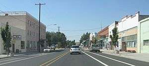
Moro, viewed looking down US Highway 97, the town's main street | |
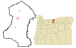 Location in Oregon | |
| Coordinates: 45°29′6″N 120°43′56″W / 45.48500°N 120.73222°WCoordinates: 45°29′6″N 120°43′56″W / 45.48500°N 120.73222°W | |
| Country | United States |
| State | Oregon |
| County | Sherman |
| Incorporated | 1899 |
| Government | |
| • Mayor | Andy Anderson |
| Area[1] | |
| • Total | 0.49 sq mi (1.27 km2) |
| • Land | 0.49 sq mi (1.27 km2) |
| • Water | 0 sq mi (0 km2) |
| Elevation | 1,799 ft (548.34 m) |
| Population (2010)[2] | |
| • Total | 324 |
| • Estimate (2012[3]) | 317 |
| • Density | 661.2/sq mi (255.3/km2) |
| Time zone | Pacific (UTC-8) |
| • Summer (DST) | Pacific (UTC-7) |
| ZIP code | 97039 |
| Area code(s) | 541 |
| FIPS code | 41-50000[4] |
| GNIS feature ID | 1124367[5] |
| Website | www.cityofmoro.net |
Moro is a city in Sherman County, Oregon, United States. The population was 324 at the 2010 census. It is the county seat of Sherman County[6] (the smallest county seat in Oregon). Moro was incorporated on February 17, 1899, by the Oregon Legislative Assembly.[7]
Geography
According to the United States Census Bureau, the city has a total area of 0.49 square miles (1.27 km2), all of it land.[1]
| Climate data for Moro, Oregon (1981–2010) | |||||||||||||
|---|---|---|---|---|---|---|---|---|---|---|---|---|---|
| Month | Jan | Feb | Mar | Apr | May | Jun | Jul | Aug | Sep | Oct | Nov | Dec | Year |
| Average high °F (°C) | 39.4 (4.1) |
44.1 (6.7) |
52.1 (11.2) |
58.4 (14.7) |
66.3 (19.1) |
73.7 (23.2) |
82.7 (28.2) |
82.4 (28) |
74.7 (23.7) |
61.9 (16.6) |
47.5 (8.6) |
37.7 (3.2) |
60.1 (15.6) |
| Average low °F (°C) | 26.3 (−3.2) |
27.8 (−2.3) |
32.3 (0.2) |
36.2 (2.3) |
42.6 (5.9) |
48.2 (9) |
54.1 (12.3) |
53.4 (11.9) |
46.2 (7.9) |
37.2 (2.9) |
30.9 (−0.6) |
24.9 (−3.9) |
38.3 (3.5) |
| Average precipitation inches (mm) | 1.48 (37.6) |
1.12 (28.4) |
1.00 (25.4) |
0.91 (23.1) |
0.97 (24.6) |
0.64 (16.3) |
0.24 (6.1) |
0.25 (6.4) |
0.50 (12.7) |
0.97 (24.6) |
1.59 (40.4) |
1.64 (41.7) |
11.31 (287.3) |
| Average snowfall inches (cm) | 5.3 (13.5) |
3.3 (8.4) |
0.6 (1.5) |
0.0 (0) |
0.0 (0) |
0.0 (0) |
0.0 (0) |
0.0 (0) |
0.0 (0) |
0.1 (0.3) |
1.9 (4.8) |
5.7 (14.5) |
17.0 (43.2) |
| Source: NOAA[8] | |||||||||||||
Demographics
| Historical population | |||
|---|---|---|---|
| Census | Pop. | %± | |
| 1900 | 335 | — | |
| 1910 | 378 | 12.8% | |
| 1920 | 418 | 10.6% | |
| 1930 | 352 | −15.8% | |
| 1940 | 309 | −12.2% | |
| 1950 | 359 | 16.2% | |
| 1960 | 327 | −8.9% | |
| 1970 | 290 | −11.3% | |
| 1980 | 336 | 15.9% | |
| 1990 | 292 | −13.1% | |
| 2000 | 337 | 15.4% | |
| 2010 | 324 | −3.9% | |
| Est. 2015 | 310 | [9] | −4.3% |
2010 census
As of the census[2] of 2010, there were 324 people, 149 households, and 86 families residing in the city. The population density was 661.2 inhabitants per square mile (255.3/km2). There were 163 housing units at an average density of 332.7 per square mile (128.5/km2). The racial makeup of the city was 92.6% White, 3.1% Native American, 2.8% from other races, and 1.5% from two or more races. Hispanic or Latino of any race were 4.0% of the population.
There were 149 households of which 21.5% had children under the age of 18 living with them, 47.7% were married couples living together, 8.1% had a female householder with no husband present, 2.0% had a male householder with no wife present, and 42.3% were non-families. 36.2% of all households were made up of individuals and 18.2% had someone living alone who was 65 years of age or older. The average household size was 2.17 and the average family size was 2.85.
The median age in the city was 48.1 years. 19.4% of residents were under the age of 18; 7.1% were between the ages of 18 and 24; 17.7% were from 25 to 44; 30.3% were from 45 to 64; and 25.6% were 65 years of age or older. The gender makeup of the city was 47.2% male and 52.8% female.
2000 census
As of the census[4] of 2000, there were 337 people, 133 households, and 94 families residing in the city. The population density was 696.4 people per square mile (271.1/km²). There were 150 housing units at an average density of 310.0 per square mile (120.7/km²). The racial makeup of the city was 92.58% White, 1.19% African American, 1.19% Native American, 0.30% Asian, 3.26% from other races, and 1.48% from two or more races. Hispanic or Latino of any race were 5.34% of the population.
There were 133 households out of which 35.3% had children under the age of 18 living with them, 52.6% were married couples living together, 15.0% had a female householder with no husband present, and 29.3% were non-families. 27.1% of all households were made up of individuals and 16.5% had someone living alone who was 65 years of age or older. The average household size was 2.53 and the average family size was 3.10.
In the city the population was spread out with 30.9% under the age of 18, 6.5% from 18 to 24, 22.3% from 25 to 44, 23.1% from 45 to 64, and 17.2% who were 65 years of age or older. The median age was 40 years. For every 100 females there were 97.1 males. For every 100 females age 18 and over, there were 94.2 males.
The median income for a household in the city was $35,625, and the median income for a family was $40,625. Males had a median income of $35,313 versus $15,417 for females. The per capita income for the city was $14,887. About 14.7% of families and 16.8% of the population were below the poverty line, including 19.0% of those under age 18 and 9.8% of those age 65 or over.
References
- 1 2 "US Gazetteer files 2010". United States Census Bureau. Retrieved 2012-12-21.
- 1 2 "American FactFinder". United States Census Bureau. Retrieved 2012-12-21.
- ↑ "Population Estimates". United States Census Bureau. Retrieved 2013-06-02.
- 1 2 "American FactFinder". United States Census Bureau. Retrieved 2008-01-31.
- ↑ "US Board on Geographic Names". United States Geological Survey. 2007-10-25. Retrieved 2008-01-31.
- ↑ "Find a County". National Association of Counties. Retrieved 2011-06-07.
- ↑ Leeds, W. H. (1899). "Special Laws". The State of Oregon General and Special Laws and Joint Resolutions and Memorials Enacted and Adopted by the Twentieth Regular Session of the Legislative Assembly. Salem, Oregon: State Printer: 1008.
- ↑ "NOWData - NOAA Online Weather Data". National Oceanic and Atmospheric Administration. Retrieved May 5, 2013.
- ↑ "Annual Estimates of the Resident Population for Incorporated Places: April 1, 2010 to July 1, 2015". Retrieved July 2, 2016.
- ↑ "Census of Population and Housing". Census.gov. Retrieved June 4, 2015.
External links
 Media related to Moro, Oregon at Wikimedia Commons
- Listing for Moro in the Oregon Blue Book
- Profile of Moro from Sherman County
Municipalities and communities of Sherman County, Oregon, United States | ||
|---|---|---|
| Cities | 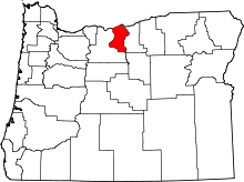 | |
| CDP | ||
| Other communities | ||