Morialta Conservation Park
| Morialta Conservation Park South Australia | |
|---|---|
|
IUCN category III (natural monument or feature) | |
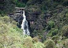
 Morialta Conservation Park showing First Falls and Morialta Gorge, note scree slope at far right. | |
 Morialta Conservation Park | |
| Nearest town or city | Adelaide |
| Coordinates | 34°54′02″S 138°42′38″E / 34.90056°S 138.71056°ECoordinates: 34°54′02″S 138°42′38″E / 34.90056°S 138.71056°E |
| Established | 2 August 1990 |
| Area | 5.33 km2 (2.1 sq mi) |
| Managing authorities | Department of Environment, Water and Natural Resources |
| Website | Morialta Conservation Park |
| See also | Protected areas of South Australia |
Morialta Conservation Park is a protected area 10 km north-east of Adelaide city centre, in the state of South Australia, Australia. The park is in a rugged bush environment, with a narrow gorge set with three waterfalls, bounded by steep ridges and cliffs. The park caters to many activities, including bushwalking, bird watching and rock climbing.
History

The land which now constitutes the Park was originally the land of the Kaurna people. Morialta is said by many to derive its name from a Kaurna word, moriatta, meaning "ever flowing" or "running water", however some linguists suggest it comes from the Kaurna words mari yertalla, meaning "eastern cascade".[1] It is said that the area was used as a hunting ground, and to collect firewood, during the winter months when the Kaurna would retreat from the coast to the hills. It is also said that they practised fire-stick farming here.[2][3] The area's religious significance appears to be lost to time. For in 1839, only three years after the proclamation of the British colony of South Australia in 1836, the area was granted by the new South Australian Government to pastoralists.[4] In 1847, John Baker bought the land and built the grand Morialta House and Morialta Barns on Fourth Creek, near the head of the gorge.[5] John Smith Reid was also a major landholder in the area, and in 1911, he offered to donate part of his land as a national reserve.
Reid donated 218 hectares (540 acres) in 1913, and in 1915 the area was declared a National Pleasure Resort. Much of the construction work in the park was begun in the 1920s and 1930s, although floods and bushfires have destroyed much of this original work. In 1966 additional property to the east was added, and the park was declared a National park. In 1972 the park was re-proclaimed as Morialta Conservation Park.
Major rebuilding was required after flooding in 1980, and flooding in November 2005 again caused damage to paths and walkways.
Geography and climate

Morialta Conservation Park covers 5.33 km² within the Mount Lofty Ranges, which run north-south to the east of Adelaide's coastal plain. It is bounded by Black Hill Conservation Park on the north, Norton Summit road on the south, the suburb of Rostrevor on the west, and by agricultural land on the east.
The park lies mostly on either side of Morialta Gorge, along the bottom of which runs Fourth Creek. There are three waterfalls on the creek, named respectively First, Second and Third Falls.
The main access to the park is via the vehicle entrance off Morialta Road, and there is walking access at various points along Norton Summit Road.
Morialta shares Adelaide's Mediterranean climate, with average temperatures of 17 degrees Celsius in winter, to 28 degrees during summer. The park receives average annual rainfall of 800 mm, mostly between May and September. During summer (December to February) temperatures can rise above 40 degrees.
Activities
The park caters for a variety of activities, including bushwalking, picnics, rock climbing and bird watching. There are many walking paths within the park.
Rock Climbing
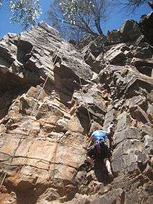
Being only 10 km from the centre of Adelaide and having a large number of climbs, Morialta is one of the most popular rock climbing areas in South Australia.[6] The rock is quartzite, and there are heavy duty rings at the top of most routes to allow for easy top-roping.[7]
There are several crags along both sides of the gorge. On the southern side, from the western end, there is Milestone Buttress, The Outcrops, The Buttress, Billiard Table, Boulder Bridge, Throne Room and Far Crag. On the northern side there is The Lost Walls and Thorn Buttress.[8] Far Crag is one of the more popular crags, with over 67 routes graded from 4 (Ewbanks) to 27.
History
The first climbing at Morialta was in 1962 by a group from the Adelaide University Mountain Club (AUMC). Four members of the club were given an introduction by the National Fitness Council and began regular climbing at the site. Access at this time was from the western end of the park (the Adelaide side) and so the cliffs to the western end were climbed first. No documentation of the climbing occurred until 1968, when Far Crag was discovered. It was named such because it is the furthest from the western end and so had the longest walk to reach it.[9]
A large number of routes were put up at the park up until the 1970s. A visit by international climbers in 1971 saw the standards of free climbing increase at the park, with many new bold routes being led. The late-1970s saw grades at the park reach 25.[10]
Remarkably, The Lost Walls were not discovered until 1986, hence their name and is the most recent addition of a significant number of climbs. 1994 saw the highest graded new route put up in the park, at 27.[11] Access is now from Norton Summit Road, on the southern side of the park.
Style of climbing
The highest volume of climbing in the gorge is done on top rope, which is made especially easy by the provision of regularly tested steel rings at the tops of many climbs. These rings greatly simplify the task of building an anchor, making outdoor climbing accessible to a broader range of people.
Although most routes can be top-roped, there are routes which are bolted for sport climbing, or suitable for traditional climbing with natural gear, or a mixture of both. Often a route which is suitable for sport or traditional climbing can also be top-roped.
Notes and references
- Notes
- ↑ http://press.anu.edu.au/wp-content/uploads/2011/03/ch182.pdf
- ↑ Park Guide - Morialta Conservation Park, Adelaide: Department for Environment and Heritage (published June 2001), 2001
- ↑ http://www.anps.org.au/documents/June_2005.pdf
- ↑ http://www.environment.sa.gov.au/parks/sanpr/morialta/european.html
- ↑ http://www.adb.online.anu.edu.au/biogs/A030076b.htm
- ↑ Pritchard 2002 p 175
- ↑ Neagle 1997, p41
- ↑ Neagle 1997, p47
- ↑ Neagle 1997, pp41-43
- ↑ Neagle 1997, p44
- ↑ Neagle 1997, p45
- References
- Pritchard, Greg (2002), Climbing Australia : the essential guide, New Holland, ISBN 978-1-86436-694-5
- Neagle, Nick (1997), The Adelaide Hills : a rock climber's guide, N. Neagle, ISBN 978-0-646-32427-2
- Department for Environment and Heritage (DEH) (2001), Morialta and Black Hill Conservation Parks Management Plan (PDF), Dept. for Environment and Heritage, ISBN 0 7590 1000 5
External links
- Morialta Conservation Park official webpage
- Morialta Conservation Park webpage on protected planet
- Friends of Black Hill and Morialta Conservation Parks, retrieved 3-12-2005